Shira Route Kilimanjaro Climb – The Complex Western Kilimanjaro Side Trail
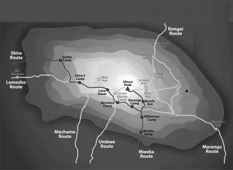
It begins at Shira Gate to the west. The first portion of the Shira Route is driven rather than hiked, making it distinctive. Therefore, it will be unattainable for climbers to use Shira in traversing one of Kilimanjaro’s biological zones, precisely the rainforest.On Kilimanjaro, the Shira route map can be seen below:
At an elevation of 11,500 feet, the Shira plateau route Kilimanjaro gate is the starting point for climbers’ trailing the course to Simba Camp. This ascent for hikers that slept in Arusha or Moshi the night before is steep. Inadequate acclimatization might lead to problems at high altitudes.
No fewer than six days is required to finish this trip; however, seven days is recommended for the best results. Mweka’s southeast slope is where the decline begins. Climbing this route is more expensive because of the added transportation expenditures in transporting climbers to the gate due to its stretch from Arusha and Moshi. Taking in the stunning Shira Plateau and then linking up with the Machame trail, Shira is a picturesque route that offers views of the southern hemisphere. Until it merges with Machame, Shira’s a less crowded entity.
Most courageous people can do Shira as long as they’re OK with walking on more difficult terrain for longer periods.
On Kilimanjaro, the Shira route map can be seen below:

An 8-Day Itinerary Schedule on the Shira Route
Day One is Shira Gate to Simba Campsite
- Traversing an altitude range of 11,800 to 11,800 feet in elevation.
- Covering a four kilometers distance.
- With a hiking time of one to two hours.
- Located in a Heath Habitat.
We set off from Moshi and arrive at Londorossi Gate in around four hours, where we’ll complete our entry paperwork while our guides and porters pack our gear. We then travel to the Shira Gate, where the hiking begins on a steep track. Simba Camp is reached after a short trek through shrubs and tall heather.
Day Two is from Simba Campsite to Shira II Campsite
- Traversing an altitude of 11,800 to 12,500 feet in elevation.
- Covering a distance of 6 kilometers.
- With a hiking time of about two hours.
- Located in a Heath Habitat.
Today is a good day to help with the Shira Route acclimatization process. Our visit is to explore the plateau’s grassy moorland and volcanic rock formations, getting to Shira Cathedral, a large rock buttress surrounded by towering spires and pinnacles, Before retreating for the night at Shira II Campsite.
Day Three is from Shira II Campsite to Lava Tower
- Traversing and altitude range between 12,500 and 15,190 feet in elevation.
- Covering a distance of seven kilometers.
- With a hiking time of four to five hours required.
- Located in an Alpine Desert Habitat.
Going to Barranco Camp from Lava Tower
- Descending an elevation of 15,190 feet to 13,044 feet.
- Covering a distance of three kilometers.
- With a hiking time of two to three hours.
- Located in an Alpine Desert Habitat.
On the way to Lava Tower, a 300-foot-tall volcanic rock formation, we continue east along a ridge on Shira Route. Our pathway takes us through the Senecio Forest, which rises to 13,000 feet before reaching Barranco Camp. Acclimatization is greatly aided by the time spent at a higher elevation during this hike, even if the day begins and ends at the same elevation.
Day Four is from Barranco Campsite to Karanga Campsite
- Ascending an elevation range of 13,044-to-13,106-feet.
- Covering a distance of five kilometers.
- With a hiking time of four to five hours required.
- Located in an Alpine Desert Habitat.
At the Great Barranco Wall base, we begin our day by descending into a ravine. We begin our ascent once we reach the non-technical but nearly 900-foot high cliff. Our descent into Karanga Valley begins from the Barranco Wall’s peak. Karanga Camp is our final destination after a grueling ascent. This is a shorter day to help you get used to the altitude.
Day Five is from Karanga Campsite to Barafu Campsite
- Ascending an altitude range of 13,106 to 15,331 feet in elevation.
- Covering a distance of four kilometers.
- Four to five hours of hiking time is required.
- Located in an Alpine Desert Habitat.
We vacate Karanga and arrive at the Mweka Trail junction, making our way up the rough path to Barafu Hut; to conclude the Southern Circuit. You’ve just finished exploring the southern mountain top circuit. Rest, have a light dinner, and prepare for the summit day at this camp. The two peaks of Mawenzi and Kibo can be seen from here.
Day Six is from Barafu Campsite to Uhuru Peak
- Ascending an altitude of 15’331′ to 19’341″ of elevation difference.
- The distance is around 5 kilometers.
- Seven to eight hours of hiking time is required.
- Located in the arctic region.
From Uhuru Peak towards Mweka Campsite
- Ascending an altitude of 19,341 feet to 10,065 feet of elevation.
- It’s a 12-kilometer trip.
- With four to six hours of hiking time required.
- Located in a Rainforest
We set off on our Shira Route ascent (about midnight). This is the toughest part of the journey, both psychologically and physically. Wind and cold can be fierce at this altitude and time of day. We get up in the dark for several hours, pausing just momentarily. Your reward is the most beautiful sunrise you’ll ever see coming over Mawenzi Peak near Stella Point at 18,900 feet. Mount Kilimanjaro’s highest point, Uhuru Peak, is now in view.
There is a short break for lunch at Barafu before we descend to the Mweka Hut tent site. As a result of the rugged terrain and potential strain on the knees, it is highly suggested that hikers use trekking poles. Due to its elevated location in the upper forest, Mweka Campsite may experience late-afternoon mist or rain. We finish the day with one last lunch on the mountain before taking a well-earned slumber.
Day Seven is from Mweka Campsite to Mweka Gate
- Descending from an altitude of 10,065 to 5,380 feet in elevation.
- Covering a distance of ten kilometers.
- Three to four hours of hiking time is required.
- Located in a Rainforest Habitat.
As we make our way down Shira Route to Mweka Gate and get our summit certificates, we’ll celebrate our accomplishments. At lower elevations, it could be rainy and muddy. Mweka Village is an additional hour’s drive from the gate. We’ll be picked up at Mweka Village and taken back to our accommodation in Moshi.
For more articles related to Things to Do in Tanzania (Zanzibar), click here!


