


")


Important Insight: Mount Kilimanjaro Routes for Climbing
There are many Kilimanjaro routes for climbing one can take to Uhuru Peak or Kibo, Mount Kilimanjaro‘s highest peak. Some of those routes are Rongai, Umbwe, Lemosho, Marangu, Shira, and Machame.
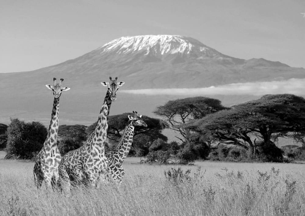
Mountain Kilimanjaro is one of the most famous mountains in the world, with over 50,000 hikers attempting to reach the summit each year. According to Climb Kilimanjaro Guide, the average rate of summit success across all routes and climbers is 65 percent. However, the summit success rate is highly dependent on the route taken, as routes differ significantly in terms of acclimatization profile and climb duration.
In this article, we’ll make a review of Kilimanjaro routes. We’ll showcase the different routes for Kilimanjaro hikes as well as trekking routes up Kilimanjaro and the Kilimanjaro routes distance.
Description of Kilimanjaro Routes for Climbing
Although getting to Uhuru Peak is quite easy, enough time must be allowed for appropriate acclimatization to avoid altitude sickness.
The three shortest Kilimanjaro routes, Rongai, Marangu, and Machame, are also the least difficult. They are frequently taken by people with little or no mountaineering expertise. Some hikers use altitude sickness medication, such as acetazolamide, but the best approach to avoid altitude sickness is to stay for at least seven days, as the body needs time to adapt and acclimate to high altitudes.
The journey to the summit and down to the foot of the mountain takes anything from five to nine days. On the Marangu route, huts with cooking facilities, restrooms, and power are available, while campgrounds with fewer amenities are offered on many other routes.
Rangers with rescue equipment (customized wheelbarrows to convey hikers suffering from altitude sickness to lower heights) are stationed at all huts and many campgrounds
On Mount Kilimanjaro, hikers usually have a support team of porters and guides who assist them in reaching the top. The Kilimanjaro National Park (KINAPA) regulates the size of the support crew, which is determined by the number of hikers in a group. Tour groups must follow KINAPA porter and guide regulations. A guide, an assistant guide, a chef, and six porters (3 for each climber), will accompany a typical climbing group of two hikers. Porters are in charge of transporting a trekker’s belongings as well as essential materials such as tents, cooking supplies, and water. Giving tips to guides and porters is traditional at the end of the journey or during the last supper on the mountain. The amount of a tip varies based on the number of days spent climbing the mountain and the number of climbers in a group.
Attempts on reaching the summit are usually started at midnight to allow hikers to reach the crater’s rim in time to see the sunrise. Walking overnight ensures that the terrain (loose sand) is frozen, making the journey much easier.
On the Marangu path, trekkers first come across Gilman’s Point on the crater’s rim, which is about a 1.5-hour journey from Uhuru Peak. Hikers who take the Southern Circuit will arrive at the peak via Stella Point, which is about an hour away.
In comparison, the Rongai path can take over two hours to reach the summit, making for a very long summit day.
The Western Breach is another option containing several scrambling parts (where hands are needed for stability and support). The rock on Mt. Kilimanjaro, however, is very fragmented, and people have died as a result of rockfall from above.
It is possible to spend the night in the crater on all southern Kilimanjaro climbing routes and on the Western Breach ascent. There are three primary benefits to this:
First, the top can be reached during the day, avoiding the nocturnal rush. Second, there is enough time to enjoy the glaciers and explore the crater. Finally, the next day’s dawn can be seen by returning to the rim very early. Kilimanjaro’s Furtwängler Glacier is a relic of the mountain’s former ice covering. Over the previous century, this has receded rapidly, with a glacial retreat of more than 80%. It was named after Walter Furtwängler; who, together with Ziegfried Koenig, were the fourth people to reach the top of Kilimanjaro in 1912.
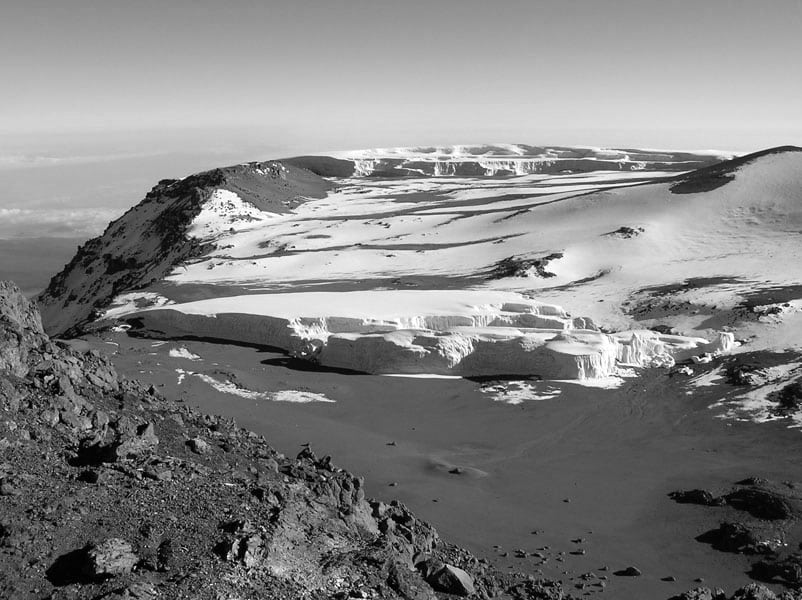
Near the peak is the rapidly receding Furtwängler Glacier.
The Tanzanian government has placed a sign at the peak of the mountain. The sign (which is only printed in English) reads:
“Congratulations on your achievement! You’ve arrived to Uhuru Peak, Tanzania, at a height of 5,895 meters above sea level. The highest point in Africa. The highest free-standing mountain in the world.”
It used to include a fourth part of the sign that said, “One of the world’s most massive volcanoes. Welcome.”
Past hikers have left their mark on the peak, and the sign is covered in travel stickers. A box near this sign contains a log that many hikers have signed.
What are the Different Routes Up Kilimanjaro?
There are different kilimanjaro routes, each offering unique experiences and challenges. Here is a list of all the different routes kilimanjaro:
Quick List of Mt Kilimanjaro Routes
Generally, there are seven established Mount Kilimanjaro climbing routes:
- Marangu Route
- Machame Route
- Lemosho Route
- Shira Route
- Rongai Route
- Northern Circuit Route
- Umbwe Route
Best Routes on Kilimanjaro
The best hiking Mt Kilimanjaro routes depend on several factors, including your fitness level, climbing experience, and personal preferences.
Here are some of the best hiking kilimanjaro routes that are popular among climbers:
Machame
- Out of all the hiking mount kilimanjaro routes, Machame is the most popular one.
- This route is also known as the “Whiskey” route since it is thought to be one of the Kilimanjaro hiking routes that is more challenging and expensive than the Marangu route. When comparing the various paths to climb Kilimanjaro, this is one of the most acceptable options, both in terms of acclimatization and expense. This route is steeper and more physically challenging in some portions than the Marangu and Rongai routes, but it is easier overall.
- With many opportunities to walk high and sleep low, it’s ideal for acclimatization.
- Hike across five different climate zones on a challenging trek with beautiful sights.
- It’s a good idea to split the pre-summit day climb so that climbers can recuperate before summiting.
- A well-known trail
- Only fully serviced camping is available.
- Climbing takes about 6–7 days.
Marangu
- The route is known as the “Coca-Cola” route because it is touted as being cheap and easy compared to the other Kilimanjaro trek routes. This is a misconception, as the route is more challenging because tof the ‘poor acclimatization profile’ compared to Rongai/Machame/Lemosho.
- Because of its reputation as the “easiest” route, it is frequently chosen by unprepared, novice climbers, contributing to the lower success rate.
- The quickest and least expensive option, but with less time to acclimate and thus a lower success rate.
- Huts with dorm-style sleeping quarters.
- Because the ascent and descent are on the same route, it is less picturesque.
Lemosho / Shira
- A high percentage of summit attempts are successful. It’s great for acclimatization, especially on extended trips.
- Dramatic gorges and views of west Kilimanjaro are found in this remote and magnificent location.
- On the fourth day, at Baranco, it links with Machame.
- Shira has a higher starting position than Lemosho, but less acclimatization.
- Only fully catered camping is available.
Kilimanjaro is approached from the west through the Lemosho route. Rather than just traversing Shira Plateau (like Machame does), Lemosho takes a lovely trek from Shira Ridge to Shira two Camp. Climbers will find little traffic until they reach the Machame path.
Then, Lemosho takes the same road called southern circuit, which includes Lava Tower, Barranco, and Barafu. Depending on your level of experience, you can complete the trek in 6, 7, or 8 days.
Rongai
- The single northern route to Kilimanjaro.
- On the initial phases of the climb, it provides an actual wilderness experience.
- From the north, the final summit night is tough.
- There are fewer options for acclimatization.
- Compared to other routes, this one is less picturesque and flat.
Also called the Nalemuru route. Rongai compensates for the lack of variety in scenery by going through actual wilderness parts for several days before linking with the Marangu route (at Kibo camp). Rongai is a somewhat demanding route that is highly recommended, particularly for people who are new to backpacking. The climb can be completed in 5, 6, or 7 days, depending on your preferences.
Umbwe
- Short, steep path with a low success rate
- Rapid ascent causes poor acclimatization.
- Very quiet and remote
- Only fully catered camping is available.
Umbwe is by far the most scenic of all the mount kilimanjaro hiking routes when going up the mountain, despite being the steepest. The Rongai is the most accessible camping path, while the Marangu is equally accessible but only offers hut accommodation. As a result, this path is often used, and the ascending and descent routes are identical. The Rongai path is flatter, but there are less chances for acclimatization. Both the Machame and Lemosho routes provide more opportunity to “hike high and sleep low,” which is essential for preventing altitude sickness.
Northern Circuit
- This is the longest ascent of all kilimanjaro hike routes, which is ideal for acclimatization.
- On a tour of the mountain, this is the only way to cross all of the Northern Slopes.
- Only fully catered camping is available.
The Northern Circuit is the newest and longest path up Kilimanjaro. It takes at least eight days to finish, but most operators provide a 9-day alternative as well. The Northern Circuit has the highest summit success rate due to its length. The path follows the Lemosho Route for the first two days, then veers off to loop around the mountain’s gentler northern slopes on the east side. There are a few route variants, but the Northern Circuit normally accesses the peak via Gilman’s Point before descending via the Machame and Lemosho routes.
Kilimanjaro Routes for Trekking
There are several official climbing routes on Mount Kilimanjaro. They are: Machame, Northern Circuit, Marangu, Londorossi Lemosho, Shira, Umbwe, Rongai, and Mweka (descent only).
Summary of the Kilimanjaro Trekking Routes
Northern Circuit
Description:
Kilimanjaro’s newest path. Due to the length of time spent on the mountain, there is relatively little traffic. It traverses practically the whole mountain, as well as the north side. The trek is long, but the sights are spectacular.
Days: 9
Length: 90 km (56 mi)
Lemosho
Description:
Lengthy access drive, remote forested trip to Barafu, camping
Days: 8(-1)
Length: 56 km (35 mi)
Machame
Description:
This is the second most famous route. A Forested route to Barafu.
Days: 7(-1)
Length: 49 km (30 mi)
Marangu
Description:
Quite popular (crowded). Long parts with gentle slopes up to 4700m (2.9 mi). In comparison to Machame and Lemosho, this is a less picturesque route with basic shelters.
Due to a rest day at Horombo Hut, the 6-day option allows for adequate acclimatization.
Days: 6(-1)
Length: 64 km (40 mi)
Rongai
Description:
Long access road, secluded, less used, with some excellent, raw, and least scenic camping. Appropriate for acclimatization.
Days: 5-6
Length: 65 km (40mi)
Umbwe
Description:
The shortest and steepest route, also the most physically demanding and needs a lot of endurance. This is a hazardous road.
Days: 6 (-1)
Length: 37 km (23 mi)
Northern Circuit
The Northern Circuit is Kilimanjaro’s newest route, taking 8–9 days to complete. It is one of the best Kilimanjaro routes. It starts from the north and winds its way clockwise around the mountain before reaching the peak from the east. This path provides a variety of views, making it very attractive.
There is relatively little traffic on this road because it is a long, wilderness route that is the only way to cross the northern face.
Because of its length, it allows for longer acclimatization time than other paths.
The trek commences at the route head at Lemosho Glades and follows a little-used footpath called Chamber’s Route, with registration for the route being at Londorossi Gate. The trail then contours around the mountain’s northern flank, passing through Shira Caldera’s high desert plateau and past Shira Cathedral before arriving at Moir Valley and Buffalo Ridge. The trail then ascends to The Saddle, a lunar terrain that runs between Kibo and Mawenzi Peaks. The overnight journey to the summit begins at School Hut campground and continues to the crater at Gilman’s Point, where a route leads to Kilimanjaro’s summit at Uruhu Peak. The park is exited via Mweka Gate after descending from the peak through Stella Point, Barafu Camp, and Millennium Camp.
Lemosho Route
This is an undeveloped, isolated, and less-traveled path to the Shira Plateau that hikers may take to ascend the Western Breach route or to connect with the Kibo South Circuit to summit the Barafu Route. There are rarely any game animals on the first day of the trek, and armed rangers never follow any group. The typical path takes 7 days on the mountain, but it can be extended to 8 days with a stay at Karanga Valley.
Route Outline
- Drive to Londorossi Park Gate (2,250m/7,380 feet) from Arusha or Moshi. A forest trail that requires a four-wheel drive vehicle leads to Lemosho Glades (2,100m (6,900 feet), 11 kilometers (6.8 miles) away, and a potential camping (park fees are not paid to camp here). Mti Mkubwa (large tree) campsite (2,750 m (9,020 feet) is reached via forest pathways.
- The trail steepens gradually as it enters the huge heather moorland zone. After crossing several streams, it reaches the Shira Ridge at around 3,600 m (11,800 feet) and descends gently to Shira 1 camp on the Shira Plateau ((3,500m (11,500 feet)). This campsite could be skipped entirely.
- Shira 2 camp is located on moorland meadows beside a stream (at 3,850m (12,630 feet) on the plateau. On the plateau, there are a range of walks to choose from, making this a good acclimatization day.
- Continue east to Kibo, crossing through the intersection, and then east to the Lava Tower. Descend to Barranco hut (at 3,940m (12,930 feet) shortly after.
- A short climb to the summit of the Great Barranco, followed by a walk across scree and slopes to the Karanga Valley (4,000m/13,000 feet), which lies beneath the icefalls of Kersten, Heim, and Decken Glaciers. The trail ascends a hill to the Barafu Hut after climbing out of the Karanga Valley, a barren place with minimal vegetation (4,600m (15,100 ft).
- The hike to the edge of the Kibo Crater between the Ratzel and Rebmann Glaciers begins early in the morning. An ice axe or ski stick is important for balance at the last part before the rim, which can be snow-covered at times. Stella point (18,652 feet (5,685 m) is reached near the rim. After another hour’s hike, you’ll arrive at Uhuru Summit, where you can often see Meru to the west and Mawenzi’s jagged peak to the east. Drop to Barafu Hut for a break and lunch before continuing beyond Millenium camp to Mweka Hut, located in the big heather zone on the forest edge. Those with enough energy on the peak may want to drop to the Reutsh Crater and see the Eastern Icefields’ ice pinnacles.
- Climbers arrive at the park gate after a 3-4 hour drop through the forest.
The Lemosho route climbs the mountain from the west, and it is less popular than the other prominent Kilimanjaro climb routes. It’s essentially a Machame version, with only the first two days of the trek different. The Lemosho route has a superb acclimatization profile, with frequent climbs, high sleep low opportunities, and high success rates. The Lemosho route is usually completed in seven days, but it can be prolonged by one day to give climbers more time to acclimate if necessary. For the Lemosho path, camping is the only viable option.
Machame Route
This is a description of the Machame route as of 2006. A six or seven day hike is usually required to complete the trip.
The following are the campsites and gates (together with their elevations):
- Machame Gate (beginning of trek) 5,718 ft (1,743 m)
- Machame (9,927 ft (3,026 m))
- Shira (12,355 ft (3,766 m))
- Barranco (13,066 ft (3,983 m))
- Karanga (optional campground, utilized by seven day climbers)
- Barafu (high campground before peak) 15,239 feet (4,645 m)
- Mweka (descent) (10,204 feet (3,110 m))
- Mweka Gate (end of trek) (5,423 feet (1,653 m))
The Machame route has the advantage of a speedy ascent to relatively high elevations (10,000 feet (3,000 meters)) and a short ascent to the Lava Tower site (15,000 feet (4,600 meters) before returning to Barranco Camp (12,700 feet (3,900 meters) on the same day.
This helps with altitude adaptation and follows the climber’s maxim “climb high, sleep low.” The steep slope helps hikers acclimate quickly.
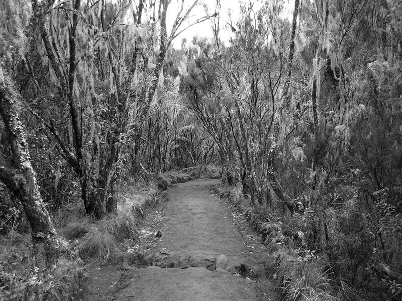
The Machame route begins at Machame Gate and ascends through the montane rainforest, defined by thick vegetation, a muddy path, and a few hard peaks. Machame Camp, the first campground, is located immediately after the intense tree cover, in a location with lower but still dense bushlands.
The second day takes you deeper into the moorlands, past increasingly scarce trees and plants. Shira Camp, located on a small plateau in the high moorlands with views of Kibo to the northeast and Mount Meru to the west, marks the end of the day. Throughout the day, white-necked ravens can be spotted. The Shira Caves are a group of small caves located a short distance from the campsite.
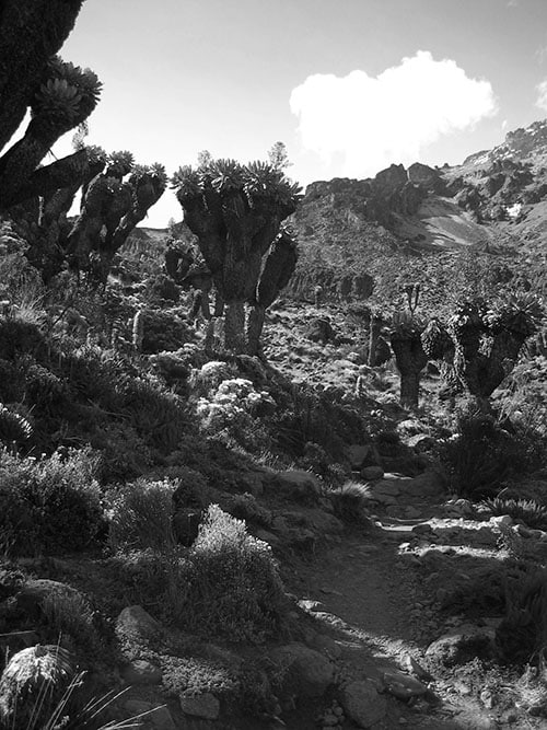
The third day begins in the moorlands and progresses to the alpine desert, which is characterized by fewer trees and more boulders. The trail ascends to the base of the Lava Tower before descending into the Barranco Valley. This zone has more vegetation, notably in the region directly before the campsite. This location is known as the “Garden of the Senecios,” because it is home to a large number of senecio plants. There are also shorter lobelia plants.
The ascent of the Barranco Wall, which is considered a scramble in climbing terms, begins the fourth day. The trail goes up and down, crossing minor creeks and rivulets before crossing the Karanga River and arriving at the Karanga campground.
The fifth day takes you up and across a rocky zone before arriving at high camp Barafu. On the harsh landscape, there is little vegetation. The ground is littered with sedimentary rocks. (Note that the six-day hike skips the Karanga campsite and hikers continues on to Barafu the next day.)
The summit is frequently attempted on the sixth day very early in the morning (around midnight). The Umbwe route also uses Barafu as a summit camping. Using headlamps and cold weather gear, trekkers often take between five and seven hours to ascent. The use of a headtorch may be unnecessary if the ascent is made during a full moon or shortly after. Stella Point (18,652 feet (5,685 m) on the crater rim is the first milestone, which is usually reached just after sunrise. The trail goes on for another 1 hour after Stella Point to Uhuru Peak, the top.
It takes about four hours to return to Barafu. Some hikers scree slide down the hill, skidding or running down the loose gravel at a moderate speed. Hikers usually take a short stop in Barafu before continuing south through the alpine desert and moors to Mweka Camp.
Hikers proceed through the highland forest to Mweka Gate on the seventh and final day. Throughout the dense vegetation, black-and-white colobus monkeys can be observed in large groups.
Detailed description:
Marangu Route
Although any ascent of Kilimanjaro is difficult, the Marangu Path (also called the “Coca-Cola” path) is the simplest of all Kilimanjaro routes. Climbs can be completed in as little as six days. It passes via The Saddle, a high-altitude, 5-kilometer-wide semi-desert that divides jagged Mawenzi from the main peak Kibo. Glaciers, cliffs, screes, forests and afro-alpine moorland descend from the summit to the farmed foothills.
Local tour operators prefer the Marangu route because it is the shortest and requires no camping kit to be carried. As a result, it is frequently the cheapest alternative. The Marangu route has the lowest summit success percentage of any route because of its short profile.
At Horombo Hut, hikers sometimes stay an extra day to adjust to the altitude. Trekkers generally begin the last hike to Uhuru Peak from Kibo Hut early in the morning because the rubble is easier to climb while frozen, and daylight views from the crater rim are mostly breathtaking.
Route Outline
- Take the road to Marangu Gate. Mandara hut is located at 2,743 m (8,999 feet) in the rain forest.
- Horombo hut (3,760 m (12,340 feet) is reached after leaving the forest and crossing open moor land.
- Recuperate and acclimatize at Horombo Hut. A day hike to Zebra Rocks or Mawenzi Hut is recommended. This is optional.
- Walk between moorland and alpine desert to “The Saddle.” Between the summits of Kibo and Mawenzi. Kibo hut (4,730 m/15,520 feet) is about an hour’s walk from here.
- Early start for the peak on steep rubble up to Gillman’s Point on the crater rim (5,681 meters (18,638 feet) Continue around the rim to Uhuru Peak (5,895 meters/19,341 feet), Africa’s highest point (approximately two hours for strong climbers). Descend to Kibo Hut, then down to Horombo Hut for the denser air and relative warmth.
- Go down to Marangu gate.
Rongai Route
Route Outline
The ‘Mawenzi Tarn Hut variant,’ which is suggested for acclimatization, is included in the route detailed below. Some trips, however, skip this step and go straight from Simba campsite to a ‘Third Camp’ at roughly 3700m, then to Kibo Hut, making for a (tougher) 5-day total journey.
- From Marangu Gate to Rongai Gate, drive 2 hours. At 2,650 meters, walk to Simba Camp (8,690 ft). The trail takes you through rain forest, plantations, and ultimately bushland.
- At 3,450 meters, walk to the second cave (11,320 ft)—a nice stroll among the bush and heathers.
- Kikelea Caves, 3,600 meters, are reached via a gentle climbing walk over moorland over many peaks (11,800 ft).
- Moorland and screes lead to Mawenzi Tarn Hut (4,330 m) (14,210 ft).
- The Saddle’s easy angled scree slopes lead to Kibo Hut, 4,700 meters above sea level (15,400 ft).
- Early start for the peak on steep rubble up to Gillman’s Point on the crater rim (5,681 m (18,638 feet) Continue around the rim to Uhuru Peak (5,895 meters/19,341 feet), Africa’s highest point (approximately two hours for fit climbers). Descend to Kibo Hut, then down to Horombo Hut for the denser air and relative warmth.
- Go down to Marangu gate.
Climbers frequently skip the second cave on their way up, despite that it is more difficult.
Umbwe Route
The Umbwe route is often regarded as the most difficult but also the most magnificent and direct approach to Uhuru Peak.
Route Outline
- At 1,800 m, drive to the Umbwe Roadhead (5,900 ft). The trail begins on a forestry path that winds its way up into the natural rain forest. The path then narrows and steepens as it climbs the slope that separates the Lonzo and Umbwe rivers. At 2,940 meters, the first campground is in the forest by several rock overhangs (9,650 ft).
- The forest stops shortly after leaving the camp, and the path continues over a narrow, magnificent ridge. As the afternoon mists sweep up the Great Barranco, the high 1,000 meter (3,300 ft) Breach Wall appears and vanishes. The route drops gradually from the Umbwe ridge to the Barranco Hut and campsite in the valley bottom at 3,900m (12,800 ft).
- The route splits at this point. From Arrow Glacier Camp, the classic route continues north to ascend the Western Breach. However, due to the significant risk of falling rock, it is recommended that you take the route described below.
- 3. A brief climb to the summit of the Great Barranco, followed by a walk across scree and slopes to the Karanga Valley (4,000 meters/13,000 feet), which lies beneath the Heim, Kersten, and Decken Glaciers’ icefalls.
- 4. After coming out of the Karanga Valley, the route climbs up a ridge to the Barafu Hut, a barren area with minimal vegetation at 4,600 m (15,100 ft).
- An early beginning for the climb to the edge of the Kibo Crater between the Ratzel and Ratzel Glaciers. The last part before the rim might be snow-covered at times, so a ski stick or ice-axe can help with balance. A further hour’s hike brings you to Uhuru Summit, where you can typically see Meru to the west and Mawenzi’s craggy peak to the east. After spending some time on the peak, go down to the Barafu Hut before carrying on down to the campsite at Mweka Hut in the large heather zone on the Mweka road.
- Climbers reach the park gate after a 3-4 hour descent through the forest.
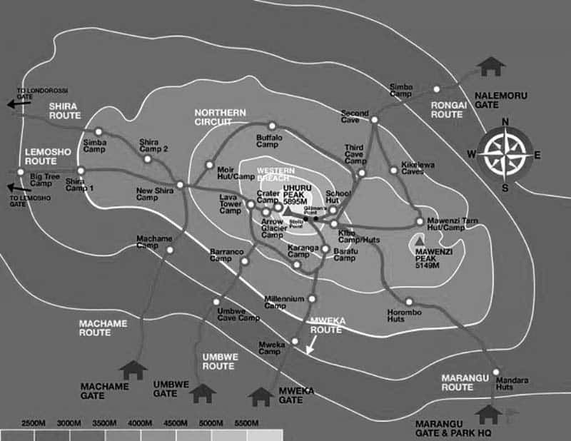
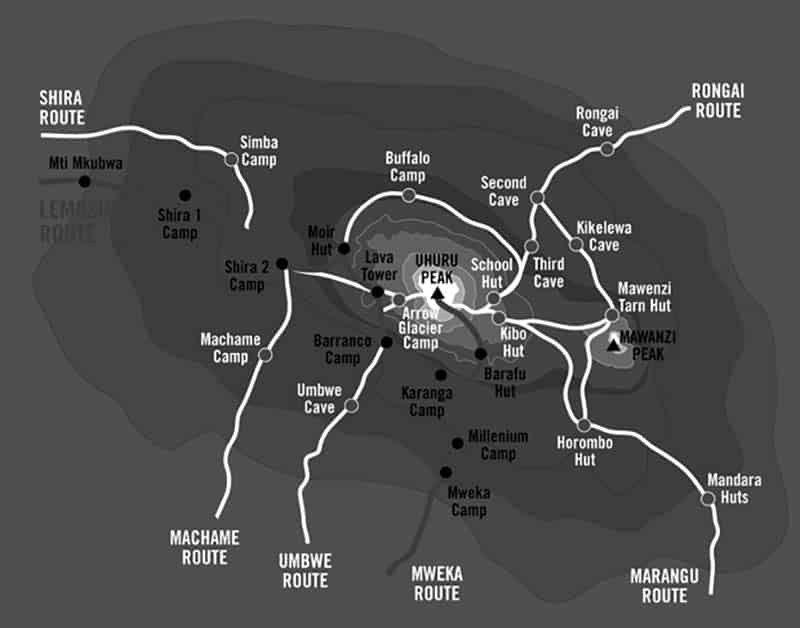
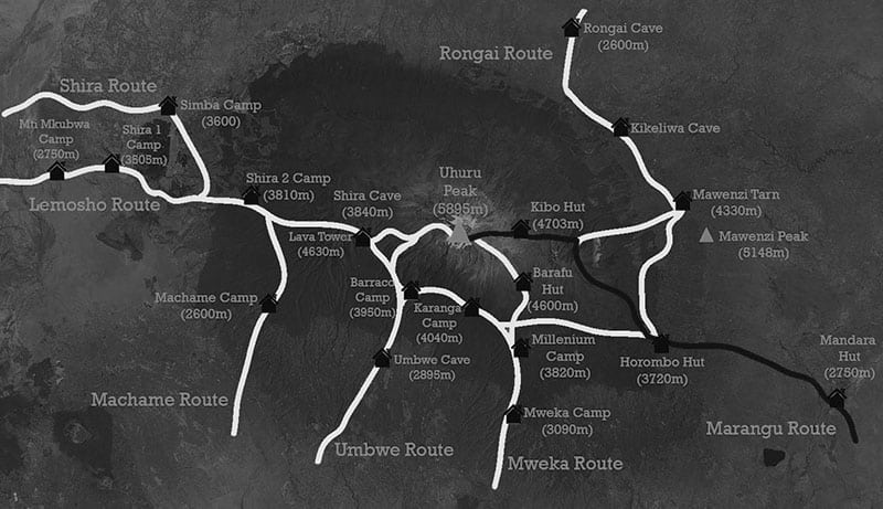
Check out this map of Kilimanjaro routes:
Acclimatization on Kilimanjaro
Because of the altitude adaptation zone notion, 7-, 8-, and 9-day climbing plans are advised.
The term “acclimatization zone” refers to a range of altitudes above which a climber is free of altitude mountain sickness symptoms.
For example, many people’s first acclimation zone is between 3000 m/9842 f and 3800 m/12467 ft.
That is, once a person has reached the lowest point and spent some time there, they will feel at ease staying within this range. This person will need to spend a night at 3700 m/12139 ft to broaden this span in order to rise higher.
Broadening one’s acclimatization zone causes some uneasiness at first, but this lessens with time. For instance, minor headaches and nausea are frequent upon reaching Mti Mkubwa Camp (3095 m/10155 f). Spending the night there will most likely diminish or eliminate them, indicating that the body has become adapted to this environment.
The lengthier the program, the more time is afforded the body for broadening the boundaries of this zone, and the more minor discomfort there will be during the acclimatization process. It will be considerably less stressful to make tiny altitude increases every day than it will be to make ‘elevation jumps.’ As a result, making altitude acclimation duration as long as possible is highly suggested.
It is most beneficial to spend an extra night at a medium altitude (3400m-4700m). This is high enough to cause the essential physiological changes for Kilimanjaro adaptation without overstraining the body. On the acclimatization day, take short walks and drink plenty of water.
Costs of Climbing Mount Kilimanjaro Routes
It is important to hike with a licensed guide is. Climbing alone is not an option. The only viable option to climb the mountain is through a tour operator, including permit fees, park fees, camping, and food logistics.
Tanzania’s Ministry of Tourism made all tourist-related businesses VAT-able in 2016. Because of this, prices have risen by 18% all over the board. As a result, many pricing indicators on the internet are out of date.
When climbing with a group, a quality ethical climb by an authorized local no-frills operator on a short 6-day route might start from roughly US$1,500. The 5 or 6 day routes, on the other hand, have the lowest summit success percentages and are therefore not recommended. A decent budget for a sensible 7-day climb is at least US$1,800 to $2,000.
The prices are directly determined by a number of things. The first is the tour operator’s quality, which in some ways also impacts the level of safety on the climb. Many organizations that aren’t listed on popular travel websites give excellent service with high-quality equipment and strong safety standards at lower prices.
The operator’s treatment and payment of the staff is the second factor to consider. Porter exploitation is a major issue on the mountain. Because tourism is the primary source of employment in the Kilimanjaro region, porter jobs are very competitive. Local businesses who operate at loss-making or cut-throat prices typically pay their porters less than minimum wage and force them to carry very heavy gear. The reputable operators are aware of the issue and pay the minimum wage. They also follow Kilimanjaro National Park laws, which ensure that the personnel is treated ethically and fairly.
On Kilimanjaro treks, a tipping culture has developed because even the minimum wage is insufficient. While low-quality operators may offer tips of only $150–200 per climber, this is almost certainly insufficient to ensure porters are fairly compensated. It’s best to allocate at least $250 to $500 for tips, depending on the size of the group, the length of the climb, the climbing package, and the tour operator’s base salaries. The irony is that ethical operators propose larger tipping amounts and are thus viewed as more expensive, yet for operators who do not pay fair wages, the recommended tipping should really be much greater in order to ensure a fair total remuneration.
So when comparing pricing, keep this in mind.
Mt Kilimanjaro Climbing Routes
Although the rock on Mount Kilimanjaro is unfit for rock climbing, several excellent snow and ice routes are disappearing fast due to glacial retreat. The peaks of Mawenzi offer a few loose rock routes to climb mount kilimanjaro.
Until lately, glacial retreat made ascending the Umbwe Route, which leads to the Heim Glacier, more difficult. The Breach Wall, located at the left of the glacier, was once regarded as one of the most difficult routes Kilimanjaro (with a 100 meters high vertical icicle). The Western Breach Path, also called Arrow Glacier, which is further left, offers a simple scrambling approach to the crater.
Using these different routes to climb kilimanjaro requires special arrangements and typically disclaimers from park authorities and outfitters. The Western Breach route, despite being a simple scramble, belongs within this category due to the risk of rockfalls.
Selected Rock Climbing Kilimanjaro Routes
- Heim Glacier: D N Goodall, H J Cooke, A Nelson, 1957. 12 hours, Grade III+.
- Western Breach: 6 hours, Grade I. The simplest rock-climbing route on the southwest of the mountain.
- Mawenzi (South Peak): George Londt from South Africa was the first to climb this in 1924.
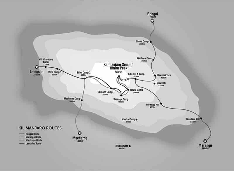
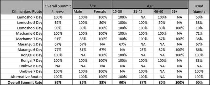
Kilimanjaro Routes Comparison
Check out this chart comparing the Mt Kilimanjaro hike routes:
To make the most of your trip to Mount Kilimanjaro, considering hiring a tour. Check out routes kilimanjaro adventures!
FAQs
How many routes up mount kilimanjaro are there?
Generally, there are seven established routes that are commonly used by climbers.
What are the seven routes up mt Kilimanjaro?
- Marangu Route
- Machame Route
- Lemosho Route
- Shira Route
- Rongai Route
- Northern Circuit Route
- Umbwe Route
What’s the Kilimanjaro routes difficulty?
The difficulty of each route up Mount Kilimanjaro can vary depending on various factors such as length, altitude gain, terrain, and weather conditions.
What are the best Kilimanjaro climb routes?
The best routes to top of Kilimanjaro will depend on your personal preferences, fitness level, and climbing experience. However, the most popular routes up Kilimanjaro are:
- Machame Route
- Lemosho Route
- Northern Circuit Route
What’s the Kilimanjaro routes success rates?
The success rates on Kilimanjaro routes vary depending on several factors such as the route chosen, the climber’s physical fitness and altitude acclimatization, and the weather conditions. However, in general, the success rates for reaching the summit of Kilimanjaro are estimated to be around 60-80% for most routes.
Are there any Kilimanjaro walking routes?
Yes, there are some Kilimanjaro walking routes that are less strenuous and are suitable for those who prefer a more leisurely pace. They’re the Marangu Route, the Rongai Route, and the Mweka Route.
For more articles related to Tourist Attractions in Tanzania click here!


