


")


The Kilimanjaro Northern Circuit: A Complete Guide
Kilimanjaro’s most recent route is the Northern Circuit. Unlike other mountaineering trips, this includes visiting the mountain‘s northern peaks while circling nearly the entire mountaintop. The Kilimanjaro Northern Circuit is the mountain’s most challenging ascent because it is the longest and the most difficult in terms of distance and duration. However, because of its higher acclimatization profile, it is the most successful course.
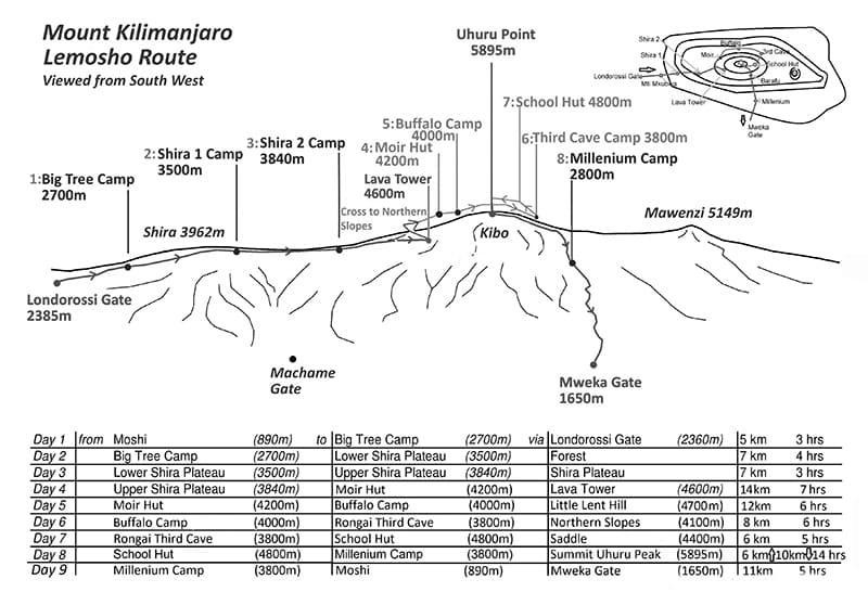
The Kilimanjaro northern circuit route map can be seen above.
A nine-day trip is required to complete the Northern Circuit.
The course begins west of the summit, on the same footpath as the Lemosho route. From Lava Tower, climbers can circumnavigate the summit clockwise at about 13,000 feet by going northwest to Moir Hut. At Third Cave, the Rongai route variant and the School Hut route cross paths. The way down is via Mweka.
In my opinion, the Kilimanjaro Northern circuit route is the most captivating path. People who enjoy long-distance hiking and search for new challenges will find ideal this excursion. This Circuit is a popular choice for walkers looking for a bit of peace and quiet.
Itinerary for the Northern Course in 9 Days
First Day:
Ascending from Londorossi Gate to Mti Mkubwa.
- The elevation ranges at the height of 7,742 to 9,498 feet
- Six kilometers traveling distance required.
- Three to four hours of hiking time is required.
- Encountered in a Rainforest habitat.
We begin our journey from Moshi and arrive at Londorossi Gate in around four hours. After necessary formalities and making our way to the Lemosho trailhead. We stroll through unperturbed woodland from the trailhead to get to our first camping spot.
Second Day:
Ascending from Mti Mkubwa to Shira Camp One.
- The elevation ranges from 9,498 to 11,500 feet above sea level.
- A traveling distance of eight kilometers is required.
- Five to six hours of hiking time is required.
- Encountered in a Heathland.
With gorgeous sights of tall grasses, heather, and volcanic rock clothed in the beard of lichen, we continue our journey from the rain forest into the savannah. We traverse spectacular rolling hills and cross multiple creeks before reaching Shira Ridge and Shira Camp One. From here on the plateau, we get our first glimpse of Kibo.
Third-Day:
Ascending the Second Shira Camp, from the First One.
- The elevation ranges from 11,500 to 12,500 feet altitude.
- The distance is seven kilometers.
- Three to four hours of hiking time is required.
- Encountered in a Heathland
The Shira Plateau is our next stop. The second Shira Camp can be reached by a delightful walk east through moorland meadows. Wildflowers and one-of-a-kind Senecio trees are found in abundance in this heath area.
Fourth Day:
Ascending Shira Camp Two to Lava Tower
- The elevation in the area varies between 12,500 and 15,190 feet.
- The distance is seven kilometers.
- Three to four hours of hiking time is required.
- Encountered in Alpine Desert.
Getting to the Moir Hut from Lava Tower.
- Descending from 15,190 to 13,580 ft in altitude.
- The distance is seven kilometers.
- Two to three hours of hiking time is required.
- Encountered in Alpine Desert.
We’ll follow a ridge eastward before turning southeast toward the 300-foot-tall Lava Tower. Once we get off the northern circuit route kilimanjaro main track, we take a short diversion to Moir Hut, a secluded spot at the base of Lent Hills. Lent Hills is a beautiful starting point for acclimatizing. Shira Plateau is one of the world’s tallest plateaus.
Fifth Day:
Still Descending: From Moir Hut to Buffalo Camp.
- From an elevation of 13’580 feet to 13’200″ feet.
- With a distance of twelve kilometers to cover.
- Hiking Time required is five to seven hours.
- Encountered in Alpine Desert.
From Moir Valley, we begin with a rather tricky ascent before making our way to the summit of Lent Hills, where we rejoin the main trail. There is a gradual ascent and descent to Buffalo Camp across a rock field on this route. The northern circuit kilimanjaro plains, extending to the Tanzanian-Kenyan border, can be seen in this course section.
Sixth Day:
From Buffalo Camp to Third Cave.
- Descending from 13,200 to 12,700 feet in altitude.
- With a distance of eight kilometers to cover.
- The hiking time is five to seven hours.
- In a Heath Habitat.
As we make our way to Buffalo Ridge, the vegetation becomes scarcer and scarcer. We will enjoy the wild sense of the highlands because this path is rarely utilized. We trek up the Mt Kilimanjaro northern circuit slopes via isolated valleys until we reach Third Cave.
Seventh Day:
Ascending from Third Cave to School Hut.
- From an elevation range of 12,700 to 15,600 feet.
- It’s a five-kilometer trip!
- Four to five hours of hiking time is required.
- In an Alpine Desert Habitat.
Mawenzi and Kibo are connected by a “Saddle,” which we progressively ascend and traverse. We continue on to School Hut, where we will be spending the night. After arriving, we’ll rest and eat a light dinner before heading to the top the next day.
Eighth Day:
Ascending School Hut to Uhuru’s peak.
- From a height of 15,600 feet to a height of 19,341 feet.
- A six kilometers trip.
- About six to eight hours of hiking time is needed.
- Encountered in the Arctic region.
Ascending from Uhuru Peak to Mweka Camp.
- From 19,341 to 10,065 feet of elevation difference.
- A twelve kilometers hiking distance.
- Four to six hours of hiking time is required.
- Encountered in the Arctic region.
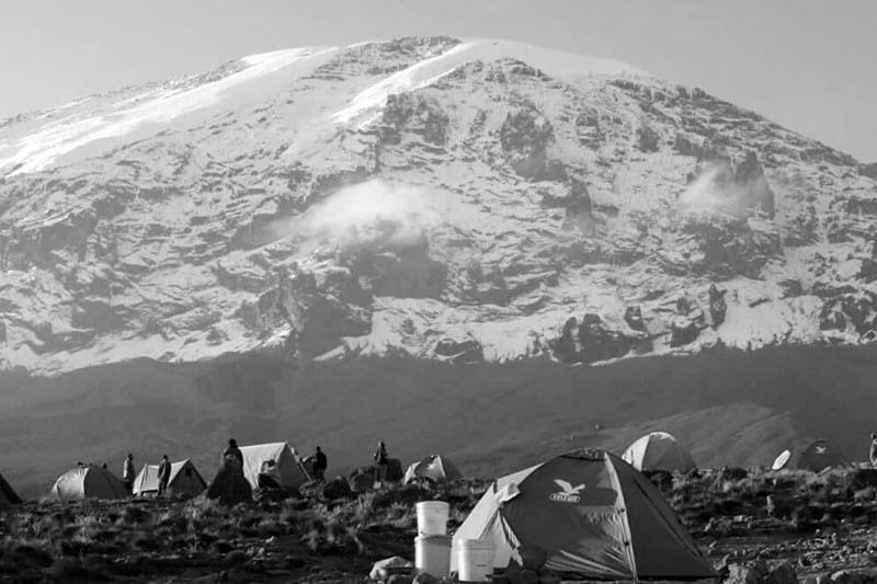
Early in the morning, we begin our journey to the summit (about midnight). This is the most physically and mentally challenging part of the trek. Wind and cold can be fierce at this altitude and time of day. We get up in the dark for several hours, pausing just momentarily. The sunrise over Mawenzi Peak will be one of the most breathtaking you’ll ever witness. Our mission is accomplished as we stand atop Kilimanjaro’s Uhuru Peak, looking out over the African continent.
Descending to the Mweka tent site. Trekking poles are highly suggested because the terrain is quite rocky and challenging on the knees. There is a short break for lunch at Barafu. Mweka Huts are located in the upper woodland; Rain or mist is often expected late afternoon. We’ll take a well-earned final dinner atop the mountain before descending the next day.
Ninth Day:
The journey from Mweka Camp to Mweka Gate
- Descending from an elevation of 10,065 feet to 5,380 feet.
- Covering a distance of 10 kilometers.
- Three to four hours of hiking time is required.
- Hiking through a rainforest habitat.
We’ll make our way back to Mweka Gate to pick up our summit credentials on our last day. Lower elevations may have rain and sludge. The journey to Mweka Village takes an additional hour once it passes the gate. We’ll be picked up at Mweka Village and taken back to our accommodation in Moshi by car.
For more articles related to Things to Do in Tanzania (Zanzibar), click here!


