


")


Mount Kilimanjaro’s Rongai Route – A Climb from the North
The Rongai Route Kilimanjaro is the singular footpath to reach the summit from the north side, nearest to the Kenyan boundary. Comparable to Marangu’s ascending profile, Rongai’s ascending profile is similar. This is a less taxing route up Mount Kilimanjaro. The Kilimanjaro climb Rongai route is steady and modest. On the other hand, this route is less crowded and travels through rural wilderness areas, unlike Marangu. The Kilimanjaro Rongai route course permits you to see wild creatures during your first day hiking expedition.
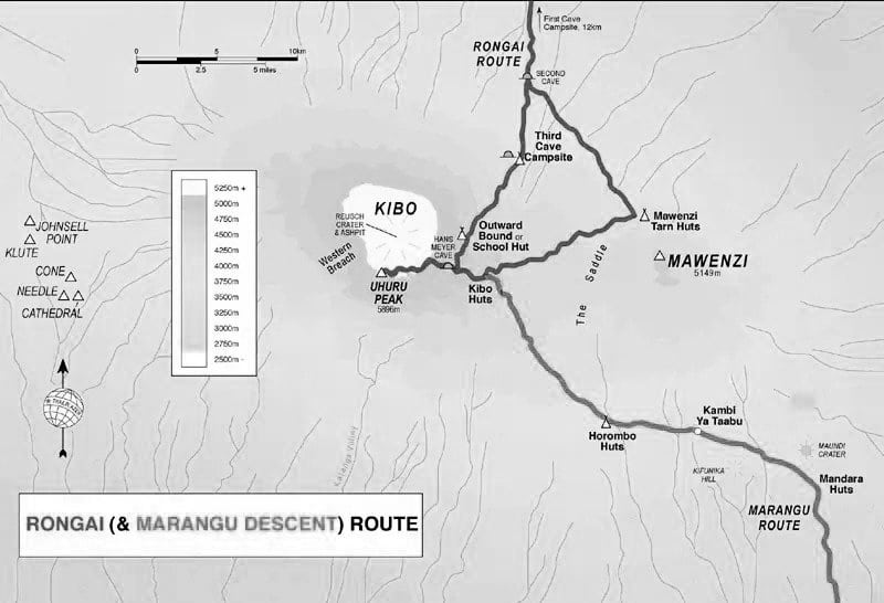
The Rongai trail on Kilimanjaro is depicted on the Kilimanjaro Rongai route map below.
The Rongai Route Success Rate
A minimum of six days is required to complete the Mt Kilimanjaro Rongai route, although seven days is recommended. Mweka, on the mountain‘s south-eastern flank, provides the route for descending down the mountain. The Rongai route cost is more expensive to climb because of the added transportation expenditures involved in transporting climbers to the gate from the starting point in Moshi.
Rongai Route Pros and Cons- Rongai Route Reviews
Rongai’s trek through a pristine rain forest and its isolated wilderness location make it a beautiful sight. But compared to Lemosho, Machame, and Shira Kilimanjaro routes Rongai lacks variety in the natural landscape.
The Rongai route is an excellent choice for individuals who are doubtful of their Kilimanjaro Rongai route success rate/ ability to trek up steeper hills, for those who want to avoid gridlock, and for those who want a more relaxing experience. The mountain’s north side receives less downpour during the wet season, making Rongai route Kilimanjaro climb a better option.
Climbers can choose between the Rongai route 6 days hiking or the Rongai route 7 days itinerary. To learn more about the Rongai route mt Kilimanjaro, please see the Kilimanjaro Rongai route 6 days– 7 days itinerary.
Rongai Route Itinerary:
The Seven-Day Trip on Rongai Route.
Day One:
Accessing the Rongai Cave via the Rongai Gate.
- Ascending from 6,398 to 9,300 feet in altitude.
- Traveling a Rongai route distance of eight kilometers.
- Three to four hours of hiking time is required.
- Located in a Tropical Rainforest habitat.
After obtaining permits at Marangu Gate, team Kilimanjaro Rongai route drive to the trailhead at Rongai Gate. The trail meanders through fields of potatoes and corn before ascending into a densely populated forest, home to the black and white colobus monkey.
Day Two:
Rongai Cave leads to the Second Cave.
- Ascending a range of 9,300 to 11,300 feet elevation.
- Traveling a distance of six kilometers.
- Three to four hours of hiking time is required.
- Located in a Heath Habitat.
From Second Cave to the Kikelewa Cave.
- There is an elevation range of 11,300 to 11,811 feet according to the Rongai route map.
- Traveling a distance of six kilometers.
- Three to four hours of hiking time is required.
- Located in a Heath Habitat.
We’ll begin our journey to Second Cave by morning with a gradual ascent. We carry on through the moorland, taking a side route to the zigzagged cliffs of Mawenzi and spending the night in Kikelewa Cave.
Rongai Route: Day Three
From Kikelewa Cave to the Mawenzi Tarn.
- Ascending an elevation ranging from 11,811 to 14,160 feet.
- The distance is five kilometers.
- Three to four hours of hiking time is required.
- Located in an Alpine Desert Habitat.
It will be a short and abrupt climbing up a bushy slope for this day. There are amazing views of the wilderness in this area. The landscape changes when we leave the forest zone and enter the Alpine Desert. The Mawenzi Tarn camp is nestled under the imposing spires of this area. The rest of the day is on your own for leisure activities or further exploring.
Day Four:
Ascending Mawenzi Tarn to Mawenzi Ridge.
- From ranges in elevation of 14,160 to 14,400 feet above sea level.
- Traveling distance of two kilometers.
- You’ll need between one to two hours of hiking time.
- Located in an Alpine Desert Habitat.
Descending towards the Mawenzi Tarn from Mawenzi Ridge.
- The elevation is 14,400 feet to 14,160 feet above sea level.
- Two kilometers travel distance is required.
- You’ll need between one to two hours of hiking time.
- Located in an Alpine Desert Habitat.
An additional day reserved for acclimatization is spent day hiking on Mawenzi Ridge. One-of-a-kind vistas of Mawenzi/Kibo are provided by this unique location. After a quick jaunt around the neighborhood, we’ll steer about to Mawenzi Tarn for the night.
Rongai Route: Day Five
Ascending Marwenzi Tarn towards the Kibo Hut.
- From an elevation of 14,160 to an altitude of 15,430 feet.
- Traveling a distance of eight kilometers.
- Five to six hours of hiking time is required.
- Located in an Alpine Desert Habitat.
Our first challenge is the “Saddle” sitting in the middle of Mawenzi and Kibo, a lunar desert. Our camp is situated at the Kibo crater wall base. Rest and a light dinner will help us be ready for the summit on the following day.
Day Six:
Ascending Kibo Hut to Uhuru Peak.
- From an elevation range of 15,430 to 19,341 feet above sea level.
- With a traveling distance of six kilometers.
- Hiking takes six to eight hours.
- Located in Arctic Habitat.
From Uhuru Peak to Horombo Hut.
- Descending from 19,341 to 12,250 feet in elevation.
- With a distance of sixteen kilometers.
- Four to five hours of hiking time is required.
- Located in a Heath Habitat.
In the early hours of the morning, we begin our Rongai Route Kilimanjaro day six ascent (at midnight). In this section of the walk, both physically and mentally, you’ll feel the strain. The wind and cold can be particularly harsh at this altitude and time of day. We get up in the dark for several hours, pausing just momentarily. The sunrise above Mawenzi Peak will be one of the most breathtaking you’ll ever see. You can see it from Gilman’s Point (18,600 ft). We’ve made it to the top of Kilimanjaro’s highest peak, Uhuru Peak, standing on the roof of the African continent itself.
Our descent to the Horombo Hut begins after a few minutes of contemplation of the African plains and your accomplishments. This takes us to our final dinner, and we sleep on the mountain before returning to civilization the next morning.
Day Seven:
Accessing Marangu Gate from Horombo Hut.
- According to the Rongai route Kilimanjaro map, we descend 12,205 to 6,046 feet in elevation.
- Traveling through a twenty-kilometer distance.
- Five to seven hours of hiking time is required.
- Located in a Tropical Rainforest Habitat.
We begin our final day with a long, mostly downhill tk Rongai Route ramble through the tropical trees. We receive our summit credentials at the Marangu Gate, the park headquarters. To get back to our accommodation in Moshi, we’ll be picked up here by car.
For more articles related to Things to Do in Tanzania (Zanzibar), click here!


