


")


Kilimanjaro Umbwe Route – The Rarely Opted and Less Crowded Trail
Because it is so rarely used, the Umbwe Route is one of the mountain‘s least crowded access points. It’s the most difficult route on the mountain for a reason. The ascent to the peak of Umbwe is a long, steep, and straight one.
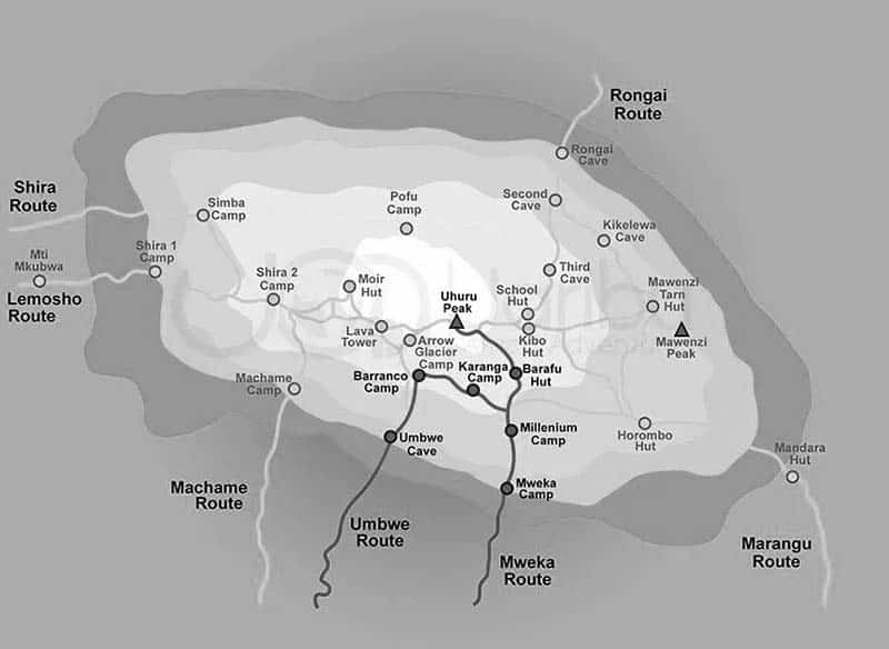
The Umbwe Route Kilimanjaro map is shown here.
The ascent shape of the Umbwe Route does not give climbers enough time to acclimate to the altitude; hence it is generally avoided. As a result, Umbwe route success rate is very very low.
The trip can be completed in fewer than six days, although it is recommended that you take at least seven days. Mweka, the mountain’s southeast flank, is the route of choice for the descent. Because of the closeness of the ascending and descent routes, Umbwe lacks the scenic variation of Shira, Machame, and Lemosho.
Those who enjoy a challenge and are comfortable traversing steep slopes will have a tremendous challenge on the Umbwe course. It is only for those who are confident that the hard program will not hinder their ability to acclimatize to the altitude. In addition, Umbwe is great for those looking for a more remote hike.
Umbwe Route 6 Days Hiking Timetable
The First Day: From Umbwe Gate to Umbwe Campground
- Traversing an elevation range of 5,249 feet to 9,514 feet above sea level.
- Traveling a distance of eleven kilometers.
- Five to seven hours of hiking time is needed to complete.
- Situated in a Heath Habitat.
For the first 50 minutes of the day, we travel to Machame Gate to register. Villages, banana farms, and coffee line the path to Umbwe Gate as we continue our journey. The walk begins with a sudden ascent on a woodland trail in the rainforest. The trail narrows and steepens as we climb the slope between the rivers ringed by huge trees. The Umbwe Camp is tucked away in a lush forest of trees and flora.
The Second Day: From Umbwe to Barranco Campground
- Traversing an elevation range of 9,514 to 13,044 feet above sea level.
- Traveling a distance of six kilometers.
- Four to five hours of hiking time is needed to complete.
- Situated in a Heath Habitat.
There is less vegetation and straggly, moss-covered trees on the second day of the Umbwe Route hike, making the landscape harsher. We can see Kilimanjaro peeping as we rise in elevation. As we near Barranco Valley, the terrain flattens out a bit. A strange but stunning Senecio Forest provides the path from Umbwe Ridge to Barranco Camp.
The Third Day: From Barranco to Karanga Campground
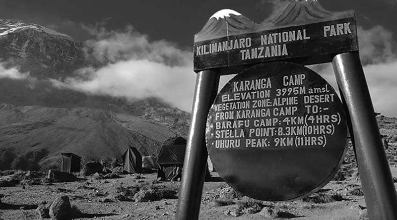
- Traversing an elevation range from 13,044 to 13,106 feet above sea level.
- Traveling a distance of five kilometers.
- Four to five hours of hiking time is needed to complete.
- Situated in an Alpine Desert Habitat.
Our journey to the Great Barranco Wall begins with a ravine drop. After that, we make our way up the cliff’s non-technical but nearly 900-foot-high face. Karanga Valley is at a short distance from the Barranco Wall. Karanga Camp is reached after yet another strenuous ascent. This is a shorter day to help you get used to the altitude.
The Fourth Day: From Karanga to Barafu Campground
- Traversing an elevation range of 13,106 to 15331 feet above sea level.
- Traveling a distance of four kilometers.
- Four to five hours of hiking time is needed to complete.
- Situated in an Alpine Desert Habitat.
After leaving Karanga, we come to a fork in the Umbwe Route where the Mweka Trail meets. We make our way up the rocky incline that leads to Barafu Hut. You’ve now completed the Southern Circuit, which offers a variety of vantage locations for taking in the vista from the peak. Rest, have a light dinner and prepare for the summit day at this campground. Kibo and Mawenzi can be seen from this location.
The Fifth Day: From Barafu Campground to Uhuru Peak
- Traversing an elevation range of 15,331 to 19,341 feet above sea level.
- Traveling a distance of five kilometers.
- Seven to eight hours of hiking time is needed to complete.
- Situated in the Arctic zone.
Descending from Uhuru Peak to Mweka Camp
- From a height of 19,341 feet to 10,065 feet.
- Traveling a distance of 12 kilometers.
- Four to six hours of hiking time is needed to complete.
- Situated in a rainforest habitat.
Early in the morning, we begin our Umbwe Route ascent in the darkness of night. This is the most physically and mentally challenging part of the trek. Wind and cold can be fierce at this altitude and time of day. We get up in the dark for several hours, pausing just momentarily. You will be treated to one of the most breathtaking sunrises ever as it rises over Mawenzi Peak, near Stella Point, at about 18,900 feet. We’ve accomplished our mission as we stand atop Kilimanjaro’s Uhuru Peak, looking out over the African continent.
Following a quick lunch break at Barafu, we begin our Umbwe Route descent to the Mweka Hut camping ground. Trekking poles are highly suggested because the terrain is quite rocky and taxing on the knees. Mweka Camp is situated in the upper forest with expectations of mist or a rainy afternoon. We prepare our conclusive dinner and a night of cozy sleep on the mountain before returning to civilization the next morning.
The Sixth Day: Descending from Mweka Campground to the Gate
- From an elevation range of 10,065 feet to 5,380 feet.
- Traveling a distance of ten kilometers.
- Three to four hours of hiking time is needed to complete.
- Situated in a rainforest habitat.
Mweka Gate is where we obtain our summit credentials on the final day. At lower altitudes, it may be raining and muddy. From the entrance to Mweka Village, it takes us another hour to get there. We’ll be picked up at Mweka Village and taken back to our accommodation in Moshi.
For more articles related to Things to Do in Tanzania (Zanzibar), click here!


