


")


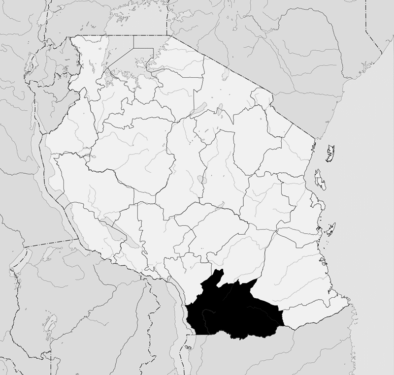
Overview of Ruvuma Region Tanzania and Its Administrative Divisions
Ruvuma Region is among the thirty-one administrative regions in Tanzania. The capital of the region is located in Songea Municipality. According to the census conducted in 2012, the region’s population is 1,376,891. This figure is less than the pre-census estimation of 1,449,830. From 2002 to 2013, the Ruvuma region’s 2.1% average yearly population growth was the 20th highest rate in Tanzania. Also, it ranked 28th in terms of population density, with 22 people per square kilometer (57 per square mile).
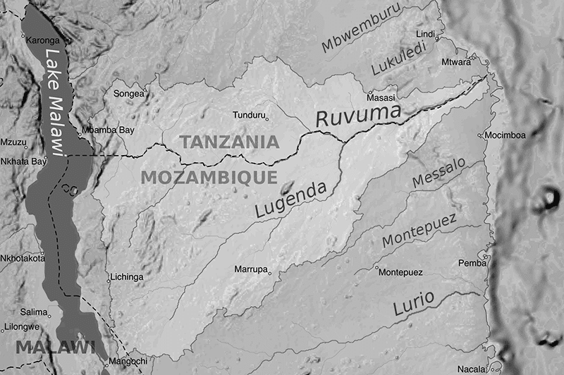
The region got its name from River Ruvuma, the second biggest river in Tanzania. Most of the Ruvuma river southern border is formed with Mozambique’s Niassa Province (where it’s called Rovuma). Morogoro Region borders the region to the north; Lindi Region borders it to the northeast, Mtwara Region borders Ruvuma to the east, while Njombe region borders the region to the northwest. There are many tribes in Ruvuma Region, including the Mpoto people. The Ngoni people are the region’s largest group. Mount Lukukura is the highest peak in Ruvuma Region.
Christina S. Mndeme is Ruvuma Region’s regional commissioner.
Administrative Divisions of Ruvuma Tanzania
Districts
Administratively, the Ruvuma region is split into 5 districts
| 2012 Census Population | District |
| 298,279 | Tunduru District |
| 203,309 | Songea Municipal |
| 173,821 | Songea District |
| 146,160 | Nyasa District |
| 201,639 | Namtumbo District |
| 353,683 | Mbinga District |
| 1,376,891 | Total |
Mbinga District
The District of Mbinga Ruvuma is among the 5 districts of Tanzania’s Ruvuma Region. Njombe Region borders the district to the north; Lake Malawi borders the district to the west. The region also shares borders with Mozambique to the south and Songea Urban District and Songea Rural District to the east. Oscar Kambona, ex-Foreign Affairs Minister, is a notable person from the district.
According to the National Census held in 2002, there are 404,799 people in Mbinga District. The district has a total land area of 11,396km2, about 18% of Ruvuma Region’s total land area and around 1 percent of Tanzania’s total landmass.
Wards
There are 37 administrative wards in the Mbinga District of the Ruvuma region.
- Kihagara
- Chiwanda
- Kihangi Mahuka
- Kigonsera
- Kilimani
- Kingerikiti
- Kilosa
- Kitura
- Liparamba
- Langiro
- Linda
- Lipingo
- Litembo
- Litumbandyosi
- Lituhi
- Liuli
- Matiri
- Maguu
- Mbaha
- Mbangamao
- Mbamba Bay
- Mbinga Urban
- Mikalanga
- Mbuji
- Mkumbi
- Mpepai
- Mpapa
- Mtipwili
- Ndongosi
- Myangayanga
- Ngumbo
- Ngima
- Nyoni
- Tingi
- Ruanda
- Ukata
- Kilindi
- Utiri
Namtumbo District
The District of Namtumbo is among the 5 districts of Tanzania’s Ruvuma Region. Morogoro Region borders the district to the north. The district is also bordered by Songea Rural District, Tunduru District, and Songea Urban District to the east, while it is bordered by Mozambique to the south. Natumbo District has a total population of 185,131 people as of 2002.
Wards
Natumbo District in the Ruvuma region has 21 administrative wards.
- Ligera
- Kitanda
- Luchili
- Magazini
- Luegu
- Lusewa
- Mkongo Nakawale
- Msisima
- Mgombasi
- Namtumbo
- Msindo
- Namabengo
- Rwinga
- Hanga
- Mchomoro
- Mputa
- Lisimonji
- Likuyuseka
- Mkongo Gulioni
- Limamu
- Mtwaro pachani
- Litola
- Suluti
- Nambecha
- Mtonya
Nyasa District
The District of Nyasa is one of the districts in Tanzania’s Ruvuma Region.
Songea Rural District
Songea Rural District is among the five districts in Tanzania’s Ruvuma Region. Mbinga District borders the district to the west, and Iringa Region borders it to the northwest. Songea Urban District and Namtumbo District border the region to the south and east, respectively, while the Morogoro Region borders the region to the north. Songea Rural District has a total population of 147,924, according to the national census held in 2002.
Songea Urban District
Songea Urban District is among the 5 districts in Tanzania’s Ruvuma Region. Songea Rural District and Natumbo District border the region to the north and east, respectively, while Mozambique and Mbinga District border Songea Urban District to the south and west, respectively. Songea Urban District has a total population of 131,336, according to the national census held in 2002.
Wards
Administratively, the Songea Urban District of the Ruvuma region is split into fourteen (14) wards:
- Bomba Mbili
- Majengo
- Songea Mjini
- Lizaboni
- Matarawe
- Subira
- Matogoro
- Mateka
- Mfaranyaki
- Mletele
- Misufini
- Mshangano
- Ruvuma
- Ruhuwiko
Tunduru District
The District of Tunduru is among the 5 districts in Tanzania’s Ruvuma Region. The districts of Lindi and Mtwara border the district to the north and the east, while Mozambique and Namtumbo District border the region to the south and west, respectively. The district has a total population of 247,976 people as of 2002.
Administrative Subdivisions
Administratively, the Tunduru district of the Ruvuma region is divided into 24 wards and seven divisions.
Divisions
The divisions in the district are;
- Mlingoti (including the entire Tunduru township)
- Lukumbule
- Nakapanya
- Matemanga
- Nalasi
- Nampungu
- Namsakata
Wards
The wards in the district are:
- Kalulu
- Ligoma
- Kidodoma
- Ligunga
- Marumba
- Lukumbule
- Matemanga
- Mchesi
- Mbesa
- Mchoteka
- Mlingoti Magharibi (West)
- Misechela
- Mindu
- Mlingoti Mashariki (East)
- Mtina
- Nakapanya
- Nalasi
- Muhuwesi
- Namasakata
- Tuwemacho
- Namwinyu
- Nampungu
- Ngapa
- Nandembo
Constituencies
Tanzania is split into constituencies for legislative elections. There are eight constituencies in Ruvuma Region
- Madaba Constituency
- Tunduru Constituency
- Songea Mjini Constituency
- Peramiho Constituency
- Namtumbo Constituency
- Mbinga Vijijini Constituency
- Mbinga Mjini Constituency
- Nyasa Constituency
Ruvuma Region Map
Other Important Things to Know in Ruvuma Region
- Tanzania Ruvuma coffee:
Tanzania Ruvuma AA is a mix of the harvests of numerous small investor farm ranches in the Mbinga Locale of the Ruvuma District of High country Tanzania, where cultivation heights territory are from 1200 to 1800 meters.
This “fat (and phat!) magnificence” is prevalently N39 and N5 (whiskey cultivar sub-assortments). Throughout the previous 20 years the thorough endeavors of two organizations, Soochak Shrubbery and Tropex, have incredibly raised the profile and nature of Mbinga espresso by consistently adding new and productive pulperies all through the locale.
This espresso is heavenly, aggressively competing against the best Kenya AA’s in cup quality and intricacy.
- Ruvuma coal limited – Quick snapshot of the company and its operations on Allafrica.com
- Mnazi bay Ruvuma estuary marine park – https://www.tanzaniatourism.go.tz/en/destination/mnazi-bay-ruvuma-estuary-marine-park
For more articles related to regions of Tanzania click here!


