


")


Embark on an Epic Adventure: Exploring Mount Kilimanjaro with the Help of a Tanzania Map
Mount Kilimanjaro, located in Tanzania, is one of the most magnificent natural wonders in the world. Rising majestically above the African plains, this iconic mountain offers a thrilling challenge for adventurers and nature enthusiasts alike. If you are planning to embark on a journey to conquer the summit of Mount Kilimanjaro, a Tanzania map can be an invaluable tool to aid you in your exploration. By understanding the geography of the mountain and utilizing a detailed map, you can navigate the various routes, plan your expedition effectively, and ensure a successful and memorable adventure.
Why use a Tanzania map for exploring Mount Kilimanjaro
A Tanzania map is an essential companion for anyone seeking to explore Mount Kilimanjaro. It offers a wealth of information, allowing you to familiarize yourself with the terrain, landmarks, and key points of interest along the way. With a map in hand, you can gain a deeper understanding of the mountain’s topography, identify potential obstacles or challenges, and make informed decisions about your route and itinerary. By using a Tanzania map, you can navigate the vast expanse of Mount Kilimanjaro with confidence and ease, enhancing your overall experience and ensuring that you don’t miss out on any breathtaking sights or hidden gems.
Understanding the geography of Mount Kilimanjaro
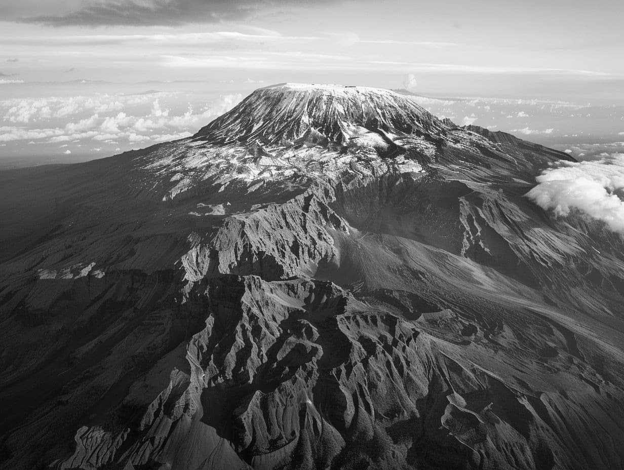
Before setting out on your Mount Kilimanjaro expedition, it is crucial to have a solid understanding of the mountain’s geography. Mount Kilimanjaro is a dormant volcano and the highest peak in Africa, standing at an impressive height of 5,895 meters (19,341 feet) above sea level. It is composed of three volcanic cones: Kibo, Mawenzi, and Shira. The landscape varies dramatically, with lush rainforests, alpine meadows, and arctic-like summit glaciers. By studying a Tanzania map, you can visualize the different zones and elevations of the mountain, allowing you to plan your ascent accordingly and ensure a safe and enjoyable journey.
Types of Tanzania maps available for Mount Kilimanjaro
There are several types of Tanzania maps available specifically designed for exploring Mount Kilimanjaro. These maps come in various formats, including traditional paper maps, digital maps, and even mobile applications. Paper maps are often preferred by those who enjoy the tactile experience of navigating with a physical map. They are lightweight, waterproof, and easily foldable, making them convenient to carry during your expedition. Digital maps and mobile applications, on the other hand, offer the advantage of real-time GPS tracking, allowing you to pinpoint your exact location on the mountain. Whichever type of map you choose, ensure that it provides detailed information about the routes, campsites, water sources, and other essential features of Mount Kilimanjaro.
How to use a Tanzania mount Kilimanjaro map for planning your expedition
Using a Tanzania map for planning your Kilimanjaro expedition is a crucial step in ensuring a successful and enjoyable adventure. Start by familiarizing yourself with the different routes available, such as the Marangu, Machame, Lemosho, and Rongai routes. Each route has its own characteristics, including difficulty level, scenery, and duration. Study the map to understand the starting points, campsites, and points of interest along each route. Consider factors such as acclimatization, weather conditions, and personal fitness when selecting the most suitable route for your expedition. By carefully analyzing the map, you can create a detailed itinerary that maximizes your chances of reaching the summit while allowing ample time for rest and acclimatization.
Essential information provided by a Tanzania map for Mount Kilimanjaro
A Tanzania map for Mount Kilimanjaro provides essential information that is vital for a successful expedition. It includes details about the altitude, distance, and elevation gain of each route, helping you plan your daily trekking distances and estimate the duration of your ascent. The map also indicates the location of campsites, water sources, and emergency rescue points, ensuring that you have access to necessary facilities and support throughout your journey. Additionally, it highlights points of interest, such as viewpoints, unique geological formations, and notable landmarks, allowing you to fully immerse yourself in the awe-inspiring beauty of Mount Kilimanjaro. Utilize the information provided by the map to make informed decisions and enhance your overall experience on the mountain.
Recommended routes for climbing Mount Kilimanjaro
When it comes to climbing Mount Kilimanjaro, several routes are available, each with its own unique charm and challenges. The Marangu route, often referred to as the “Coca-Cola” route, is the most popular and well-established route, offering comfortable accommodations in huts along the way. The Machame route, known as the “Whiskey” route, is a more scenic and challenging option, traversing through diverse landscapes and providing breathtaking views. The Lemosho route is renowned for its unspoiled wilderness and lower traffic, making it an excellent choice for those seeking a quieter and more secluded experience. Lastly, the Rongai route, starting from the north of the mountain, offers a remote and less crowded approach, with stunning views of the Kenyan plains. Consult the Tanzania map to determine which route aligns with your preferences, abilities, and expedition goals.
Tips for navigating Mount Kilimanjaro using a Tanzania map
Navigating Mount Kilimanjaro using a Tanzania map requires some essential tips to ensure a smooth and successful journey. Firstly, familiarize yourself with the map’s legend and symbols to understand the various features and markings. Pay close attention to contour lines, which indicate changes in elevation, and use them to determine the steepness of the terrain. Continuously cross-reference the map with your surroundings to maintain an accurate sense of direction and location. It is advisable to carry a compass as a backup navigational tool. Keep in mind that weather conditions on the mountain can change rapidly, so be prepared to adjust your route accordingly. Finally, always keep your map dry and protected to prevent damage and ensure its reliability throughout your expedition.
Safety precautions when using a Tanzania map on Mount Kilimanjaro
While a Tanzania map is an invaluable tool for exploring Mount Kilimanjaro, it is essential to take certain safety precautions to ensure your well-being during the expedition. Firstly, make sure to have a reliable and up-to-date map that provides accurate information about the routes, campsites, and emergency points. This will help you make informed decisions and stay on the right track. Additionally, carry a compass and learn how to use it effectively to navigate your way on the mountain. Always inform someone about your intended route and expected return time before setting out, so that they can raise the alarm if necessary. Finally, be mindful of the altitude and potential symptoms of altitude sickness. Monitor your health closely, drink plenty of water, and heed the advice of experienced guides and porters who are familiar with the mountain.
The importance of a Tanzania map for a successful Mount Kilimanjaro adventure
In conclusion, a Tanzania map is an indispensable tool for anyone embarking on a Mount Kilimanjaro adventure. By utilizing a detailed map, you can navigate the mountain with confidence, plan your expedition effectively, and immerse yourself in the breathtaking beauty of this natural wonder. From understanding the geography of Mount Kilimanjaro to selecting the most suitable route and taking necessary safety precautions, a map provides you with essential information that enhances your overall experience and ensures a successful summit attempt. So, before you set foot on this majestic mountain, make sure to equip yourself with a reliable Tanzania map and get ready to embark on an epic adventure of a lifetime.
For more articles related to Mountains of Tanzania, click here!


