


")


Songo Mnara Island – History, Layout, Excavations, Geoarchaeology and More
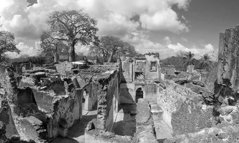
Along Tanzania’s Southern part of the Swahili Coast are the ruins of Songo Mnara. This stone town was inhabited from the 14th century to the 16th century. Songo Mnara is a UNESCO World Heritage Site, together with the neighboring Kilwa Kisiwani town.
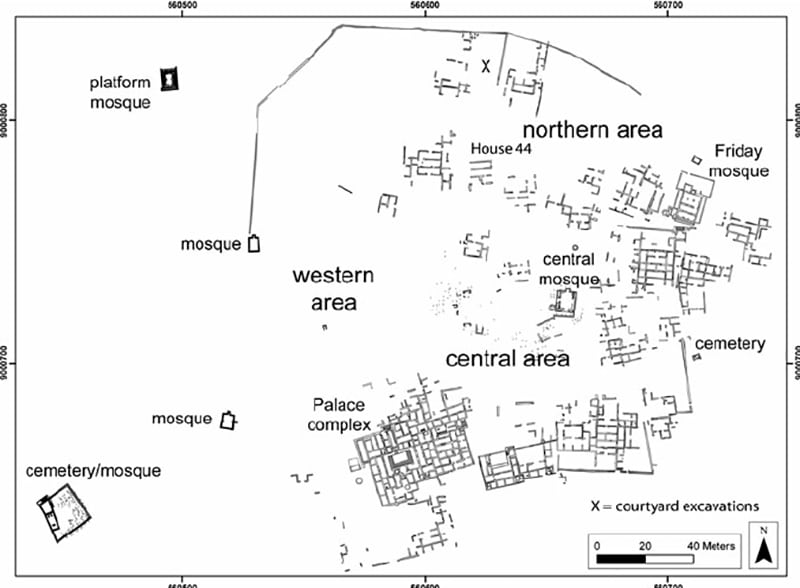
Archaeologists have discovered four cemeteries, six mosques, 12 house blocks, and three enclosed expanses on the island. The town was constructed from mortar and rough-coral. This stone town was among the various trade cities along the Indian Ocean.
Design of Swahili Cities
The analysis of the designs of stone towns utilizing Swahili architecture along the Swahili coastline by Archaeologists primarily pivoted into emphasizing the connection between the houses and mosques, to acknowledge the significance of the Swahili coast to the functions of particular towns, Islamic culture, including the intricate economic and traditional land ownership process.
The town’s open spaces were utilized for functional purposes and social organization. Cemeteries exist outside and inside the walls of the town. The design of Songo Mnara is synonymous with stone towns on the Swahili coast, although its wall is an extraordinary feature.
Excavations of Ruins of Kilwa Kisiwani and Ruins of Songo Mnara
Excavating activities have created greater awareness for archaeologists regarding the lifestyle at Songo Mnara. Excavations in various different locations were done, including many of the 40 homes on the nearby stone town.
Places, where trenches were dug, included House 23 outside the houses, House 44, by a tomb, plus a well. Various different kinds of artifacts were discovered; however, some were excavated from the already dug up houses. Archaeologists precisely recorded and mapped their discoveries.
House 44 at Songo Mnara was a critical research location resulting from the complexity of the spaces and being an individual’s home. Each room in the house had excavations, each trench was given a different number. The southwest room had a 1 x1 m test unit, dug gradually resulting from the ceramic layers.
This excavation was halted on hitting a plaster level beneath the floor. Another existed on the southwest part of the house about 4 x 2.25m. Ceramics were also discovered here. The adjacent room was in the middle of the house, with discoveries of coral and plaster in the layers of rubble.
Here, excavations were halted at the plaster floor. Excavations also happened at the entrance room, backroom, and southeastern room of the house. 15th-century ceramics were discovered at house 44.
The location of House 23 was in Songo Mnara’s southwestern corner. Because of time constraints, just samples were obtained from this house instead of complete excavation. A 4 x 1m unit was placed in the house’s courtyard.
While excavating, steps were unearthed, including coral bedrock floor. The adjacent room was the middle room where a 2 x 2m unit was placed. A plaster floor such as that found at House 44 was discovered here.
Excavations in houses 31, 34, and 40 happened as part of the Songo Mnara 2011 field school. Preliminary research happened during a 2009 field school. Six areas in the house are where the archaeologists did the Songo Mnara 2009 excavations. Plaster floors were discovered again at every house including artifacts.
Ceramics tested to support a lot activity after being discovered at one of the front doorways. The tested backroom never showed similar activity as the front rooms since they were very tidy, unlike the front room.
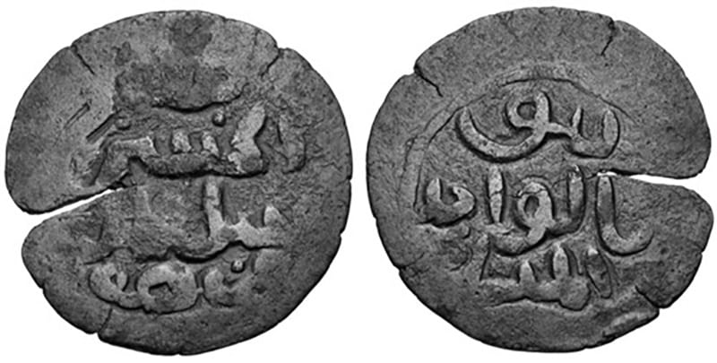
As part of this field school, coins similar to those in Kilwa were discovered underneath the floor. The information discovered at these houses revealed the open space and also the fact that houses were shared at the site.
A part of the 2009 field school, excavations happened on Songo Mnara open spaces. The structures laid out every activity that made the private space separated from public space. By archaeological analysis, a lot of activity was found in the ceramic layers and other artifacts.
Coins were part of the discoveries in open spaces, considering all the open spaces there as spaces utilized for activities done specifically outdoors. During the Songo Mnara field school in 2011, the open space was considered too during the shovel test pits, taking into account what the soil potentially reveals to a person about the site at the moment. Trenches were also dug, proving from the artifacts connection of the areas to household routine activities.
As part of the field school in 2011, mosques were looked at, unlike in the 2009 field school at Songo Mnara. The central mosque was looked at to understand Songo Mnara. Considering the graves, it was evident people cared for those buried soon after burial.
Geoarchaeology
The town is an island constructed on top of sandy subsoil and bedrock. Its nearness to the Kilwa Kisiwani epicenter and limited occupation offers a conducive environment for geoarchaeological research.
By 2011, Songo Mnara soil samples were obtained for geoarchaeologists to conduct phytolith and microstratigraphy chemical analyses to separate naturally deposited matter from human residents’ deposits.
Two open areas were tested: at Songo Mnara’s northern end and another at the southern end. Samples from rooms containing fill were tested including from the floors of the houses. Various palm phytoliths were discovered in house 44 samples, which is unnatural.
Public Places
Research conducted in public spaces at Songo Mnara was aimed at seeing the potential of urban centers to help us realize the designs for towns. In the wall surrounding the town is a vast space without any architecture, and public area. Cemeteries and mosques are part of public space.
Archaeological micromorphology, testing, and phytolith techniques are modern methods of considering public areas. Seven areas were considered for this research: the shoreline in the west and places having daub and wattle housing.
These Songo Mnara locations have a wide range of artifacts related to houses in the open space. Considering the geochemical data, a lot of human activity was discovered along the western shoreline and places having daub and wattle.
Location three considered space especially the public areas including the space for cemeteries/mosques. While testing in this location, there was the discovery of Iron implements in primary context, revealing the presence of iron smithing in the town.
Location four has tombs and graves in the middle area, revealing that the people memorialized those whose graves are there. To memorialize those buried, Kilwa coins were used to remember loved ones buried there. Ceramic shards were discovered probably utilized to remember those buried.
Location five includes the cemetery and the mosque. This particular Songo Mnara place was considered for the layout of the markers, including the positioning of the mosques. The geophysical considered the soil for being suitable for burial, but there was no discovery of grave goods.
The sixth location includes an area for a public well, revealing this location is the most secure of all other locations. A landfill existed while excavating near the well having various artifacts. The final area for consideration is the northern community area, revealing through phytolith research the possibility of orchards or garden plots in the area.
During excavation, various household and domestic items were discovered in this area since it was very near to the houses. Considering Songo Mnara’s public spaces three different community spaces existed: green area, organized centers, and one for non-elite members.
Houses for Public Areas
Researchers have investigated the design of house 44 at Songo Mnara. Backrooms had artifacts, although the soil sample for the hallway had traces of palm phytoliths. Every backroom revealed signs of various activities compared to the open area. Excavations of various other homes follow some findings in house 44. The hallway in house 31 including the middle room for house 23 differed from matching rooms in house 44, relatively since house 23 is superior to house 44.
Discovered artifacts in every room of all houses at Songo Mnara suggested a unique activity. Coins in the middens (garbage heaps) together with burials in the backroom suggested the house wasn’t private, but a community space for doing business. This differs from past research about the houses on the Swahili coast.
The proof suggested that what happened in the commercial city was coming up in the houses people lived in. This showed the nonexistence of a defined method for determining a public space and a private space.
Coins Originating from Kilwa
The coins date back from the 11th century to the 16th century. Of all coins, most were legible. These were unearthed through excavating trenches all over Songo Mnara, mainly in the layers of the floor. The types discovered at this site are al-Hasan b. Sulaimān, Nāsir al-Dunya and ‘Ali b. al-Hasan. Poor preservation made reading Nāsir al-Dunya hard.
Many of the Kilwa coins at Songo Mnara had ‘Ali b. al-Hasan inscriptions. People could have left these coins on the surface, since they preexisted the occupation of the site, because of the periods earlier compared to inhabiting the location.
Commerce
Swahili coast trade was from India, China, and other countries that engaged in the Indian Ocean trade. When considering trading partners with Songo Mnara, there was evidence of ceramic shards from southeast Asia and China. Chinese ceramics included blue/white porcelain, stoneware with green glazing going to the 14th century.
Pieces from Southeast Asia were not glazed and stoneware with green glazing from Thi. Just a tiny amount of foreign items was discovered because of agriculture carried out on site. Ceramics discovered at Songo Mnara were for exchange.
Documentation Using 3D Scanning
From 2005 to 2009, there was documentation of the Swahili ruins at Songo Mnara by the Zamani Project using 3D Lidar, scanning. Structures documented included: the mosque, palace, and some residential structures. Some elevations, plans, textured 3D models, sections, and panorama tours are available at www.zamaniproject.org.
For more articles related to Tourist Attractions in Tanzania click here!


