


")


Kilwa Kisiwani Tanzania – Significance, Economy, Buildings, History and More
Kilwa Kisiwani (meaning Kilwa Island in English) is an island, hamlet community and archaeological site situated in the Kilwa Masoko town, Kilwa District in the Lindi region of southern Tanzania. Among nine hamlets in the Kilwa Masoko town, it is the largest and the least populated with less than 1,000 inhabitants. More than 10,000 inhabitants were hosted in Kilwa in the Middle Ages while at its highest point. UNESCO has however designed ruins of Kilwa Kisiwani and ruins of Songo Mnara, as a World Heritage Site since 1981. Notwithstanding its reputation historically, Kilwa Kisiwani continues to remain home to a few resilient native residents who have lived on the island for hundreds of years. The island is seen as one of the seven World Heritage Site situated in Tanzania.
Geography
The circumference of Kilwa Kisiwani is 14 mi (23km) with 4.6 sq mi (12 km2) as the total land area. Kilwa Kisiwani lies at 9 degrees south of the equator, with the Mavuji River estuary located on the west side of the island. The Sagarungu sound is seen in the south side while the Indian Ocean lies on the eastern part of the island.
Economic Outlook of Kilwa Kisiwani Island
Kilwa Kisiwani is situated with the township authority of Kilwa Masoko and is known to carry out economic activities such as fishing, cultural tourism and subsistence agriculture. There is however low economic growth owing to restricted access to the island. Wells are the major source of water for Kilwa Kisiwani since there are no rivers found in it. For over a thousand years now, many of the freshwater wells found in the island have been used. There are also small boats in the island used to and from by the natives at Kilwa Masoko. Power supply on the island is based on solar and is of low capacity. Transportation on the island is done mostly by way of foot or motorcycle since the island has no roads. There are strict prohibitions against visits by non-island residents who do not have visitors permit issued by the tourist information center located in downtown Kilwa Masoko. This compulsory requirement of having a visitors permit for non-residents of the island is to preserve the origin and historic reputation of Kilwa Kisiwani. There are several archaeological buildings and artifacts on the island which are yet to be discovered.
Kilwa Kisiwani History Importance
Kilwa Kisiwani additionally is an historical Swahili city-state site situated on the Kilwa Archipelago, along the Swahili coast. Since the 8th century CE, the Mwera people from across the mainland have occupied the Kilwa Kisiwani and became one of the most powerful Swahili settlements along the coast of East Africa. According to historical accounts, the island was located at the Kilwa Sultanate center which is a medieval sultanate of Swahili whose authority spread through the whole of the Swahili coast during the 13th to 15th century. Trade circulations were usually impacted by seasonal wind reversals.
Ibn Battuta, a traveler and scholar from Morocco visited Kilwa Kisiwani in 1331CE and described the island as one of the world most beautiful cities. Kilwa Kisiwani’s growth and development was influenced by trade connections with China, India and the Arabian Peninsula. The origins were however African, despite the fact that the culture had adapted Islamic words and customs. Following the burning of Kilwa Kisiwani to the ground by the Portuguese in July 1505, there were no answers to many questions about the layout of the town, unlike other Swahili settlements that displayed layouts that were complex in order to reflect social relations between groups.
At the edge of the town, one would find the Swahili cemeteries which was common for the region, with wide open spaces used for community gatherings. During the 13th century, the city was considered to be significant for trade and the period witnessed greater movement of goods and more fortifications. In order to make this work, it was necessary to put in place a form of political administration to oversee the city and supervise the flow of goods. The Arabian Peninsula had much of the trade networks. During the period between the 13th and 15th centuries CE, Kilwa Kisiwani reached its peak with respect to commerce and wealth.
Around the 13th century CE, the appearance of stone structures constituted evidence of increased wealth, after which all structures became wattle-and-daub. The type of buildings individuals lived in showed their socio-economic status and position. Goods exported into Kilwa Kisiwani included gold, ivory, tortoiseshell, spices, aromatic gums and coconut oil. During this time, gold trade at Sofala, Mozambique has been seized and take control of by Kilwa Kisiwani. Commercial goods were more owned by the rich, as opposed to those persons in the lower class. Some the few items possessed by the wealthy consisted of foreign ceramics and luxury clothes, though the latter for example, is not preserved in the historical record. The minting of Kilwa’s own coins was done for approximately 500 years which continued from about 1100-1600CE, with the coins being discovered across the region particularly in Great Zimbabwe.
There were plentiful marine resources which were used for food. Other sources of food were also found in the surrounding land. With all the trade benefits and resources on Kilwa Kisiwani, the historical investigation of the harbors and ports is regarded as being significant due to the massive impact of the sea. Food sources from land had to come from higher ground areas since the soil discovered over the limestone at Kilwa Kisiwani was of bad quality. The soil would have however been best for planting cotton which could have been utilized for the production of sail. Spindle whorls of the 12th century were also discovered which evidenced the use and processing of cotton in this area.
CIV 6 Kilwa Kisiwani Ceramics
More concentration was placed on the archaeology of the ports and harbors of Kilwa Kisiwani from the beginning, but now, more priority is given to the hinterlands of Kilwa. A lot of ceramic artifacts are found at the site and they are categorized into two different groups which are regional and coastal. There was local production of all ceramics that are regionally distributed, though there was limit to the area of distribution. Ceramics that were not glazed were known as Kitchen Wares, but they were not just used for purposes of cooking. Other varieties of locally produced pottery in the region were also discovered at the site.
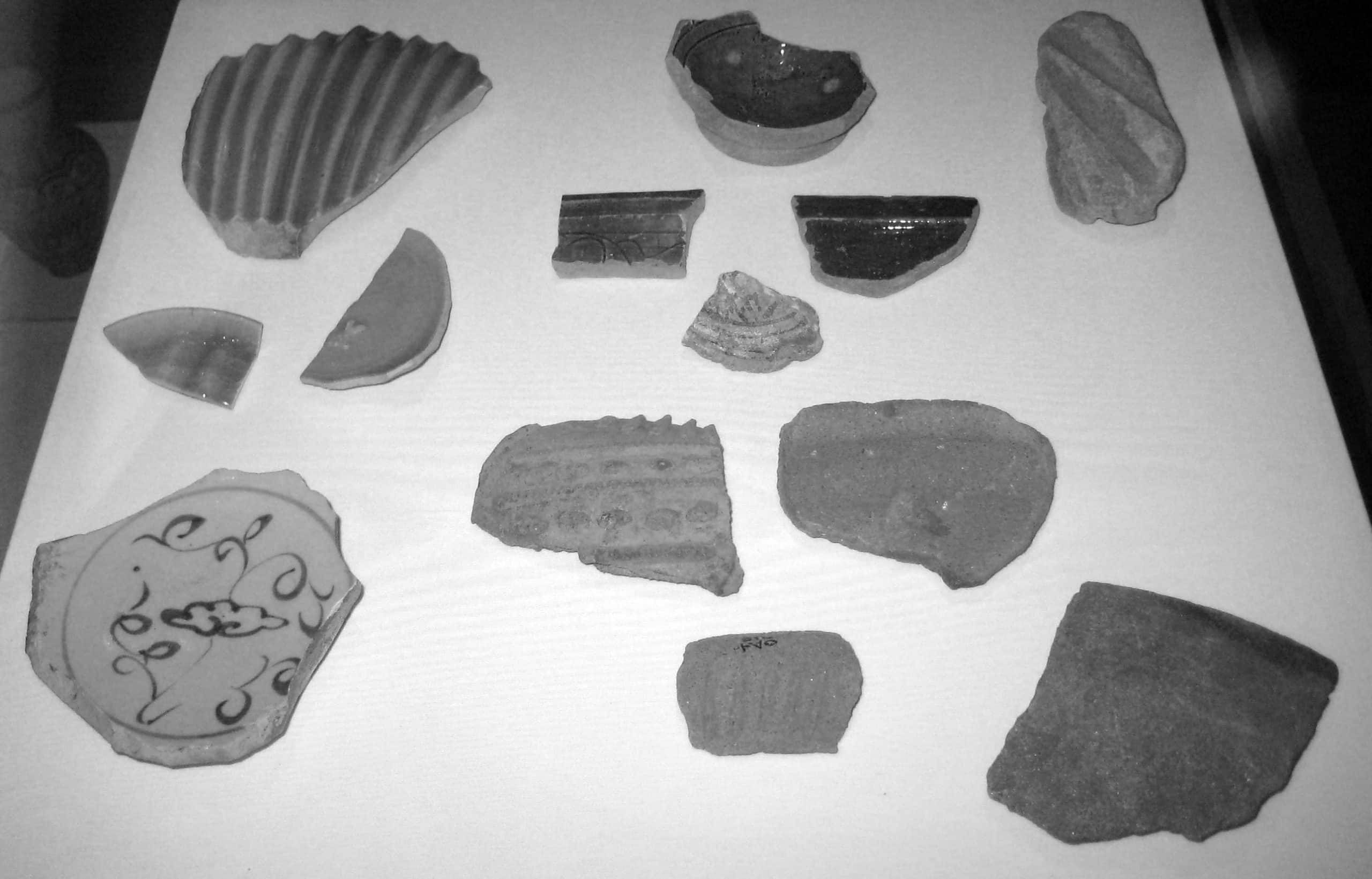
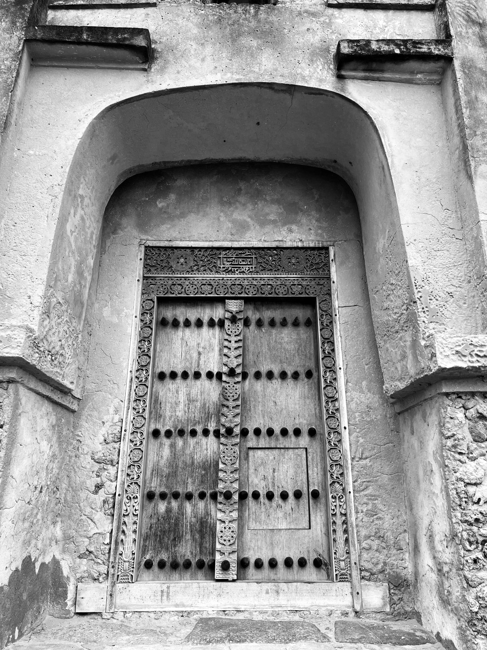
Although throughout the region the Kitchen Wares could be seen, other ceramics such as red-burnished wares and modeled forms could also been seen as well within Kilwa Kisiwani. The pattern of distribution for the red-burnished wares was coastal. Ceramic vessels imported from the Arabian peninsula and China were major types of ceramics which were limited to town and were not found in rural areas. The elite used them as signs of social status and position and kept them in wall niches constructed solely for the purpose of the display of the ceramics. Along the coast of Swahili, the imported ceramics played significant symbolic roles which progressed on to Swahili culture in the modern day. In the course of Kilwa Kisiwani going through an urbanization process, such transformation was not seen in other local communities as evidenced in the inadequacy of imported goods in the hinterlands.
Kilwa Kisiwani Ruins – Preservation of the Site
The UNESCO’s list of World Heritage in Danger made mention of Kilwa Kisiwani in 2004. As a result of diverse agents like vegetation and erosion, the monumental and archaeological heritage of these islands have rapidly deteriorated. This is exemplified by the gradual disappearance of the eastern part of the Husuni Kubwa palace. Rainwater wash which causes damage to the soil further aggravates the risks of the remaining buildings on the edge of the cliff collapsing. The progression of rainwater wash effect has been reduced by the vegetation proliferating the cliff which however, leads to the collapse of the masonry buildings. Kilwa Kisiwani was recognized in the 2008 Watch List of 100 Most Endangered Sites published by the World Monuments Fund which has supported conservation work on several structures since 2008. In 2014, Kilwa Kisiwani was however removed from the list.
Some of the Swahili ruins on Kilwa Kisiwani was documented by the Zamani Project with terrestrial 3D laser scanning between the period of 2005 and 2009. The documentation included structures like the Malindi Mosque, the Gereza (prison – also known as Gerezani Kilwa Kisiwani in Swahili language), the Makutani Building, the Great Mosque and the Husuni Kubwa. The 3D models including the sections, elevations, plans and a panorama tour can be found on www.zamaniproject.org.
Kilwa Kisiwani Facts About Its Historic Buildings
Great Mosque
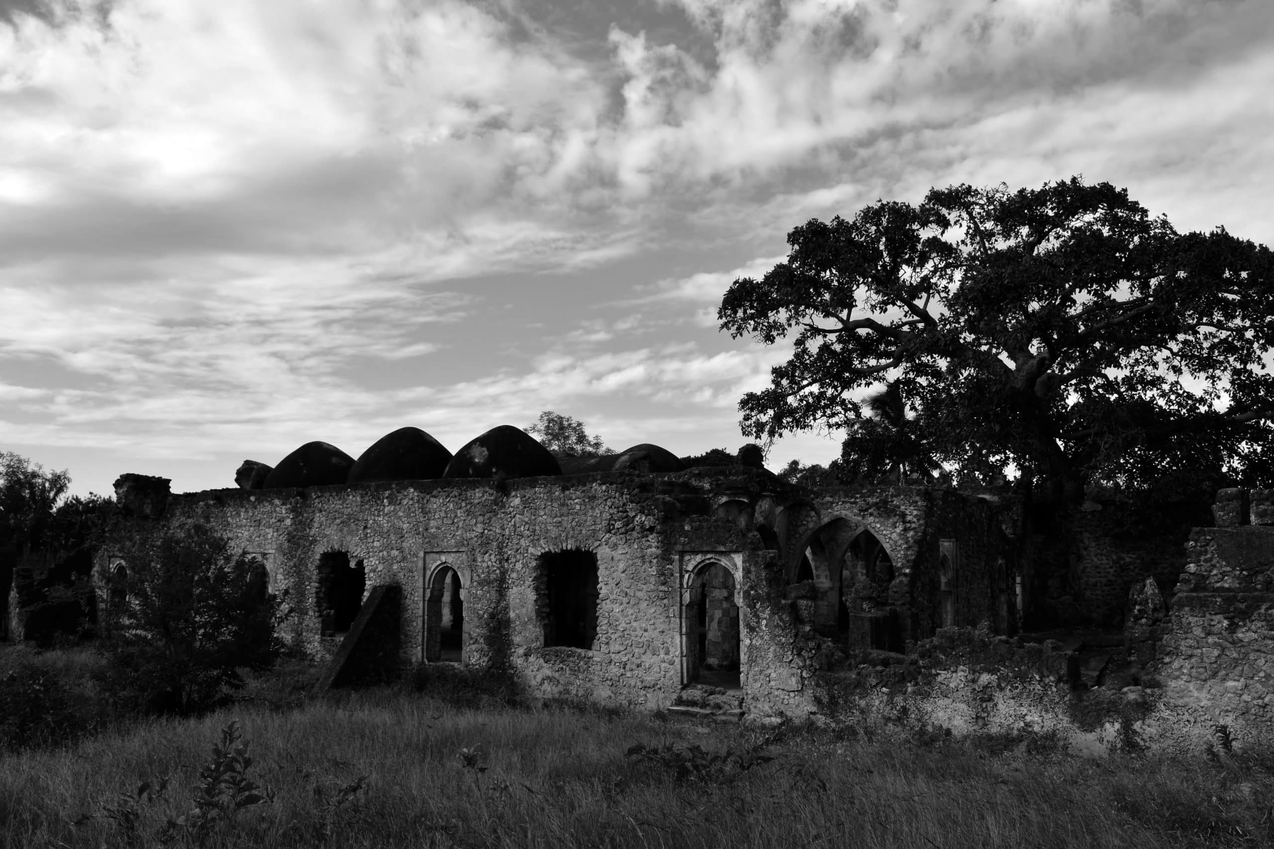
Known to be a congregational mosque in Kilwa Kisiwani in Tanzania, the Great Mosque was one of the earliest surviving mosque on the coast of Swahili which was mostly likely to have been founded in the 10th century, though the two construction stages occurred around the 12th and 13th century respectively. The first stage of construction involves a smaller prayer hall at the north which contains 16 bays supported by nine pillars carved from coral but replaced by timber. The building was completely covered with roofs and remained one of the early mosques to be constructed without a courtyard in it.
Sultan al-Hasan Ibn Sulaiman also erected the Husuni Kubwa palace in the early 14th century which is located nearby to the mosque. He included an extension on the south which consisted of a great dome. After his visit to Kilwa Kisiwani in 1331, Ibn Battuta gave some descriptions to the dome. A 3D model of the Great Mosque can be viewed from here.
Palace of Husuni Kubwa
Husuni Kubwa, meaning the ‘Great Palace’ is an early 14th-century palace and emporium of the sultan located outside town. At the entrance of the Harbour was causeways and other platforms constructed from close to a meter high blocks of coral and reef. These constitute breakwaters which facilitate the growth of mangroves, thereby serving as one of the means by which the breakwater can seen from afar. The bedrock is used to make some parts of the causeway, and is particularly used as a base. Construction of the causeways was made with coral stone, as well as lime and sand which was used to cement the cobbles together with some of the stones not left unloose.
Another reputable building in Kilwa Kisiwani is the palace of Husuni Kubwa. In the 14th century, Sultan al-Hasan Ibn Sulaiman constructed a significant part of the palace and also erected an extension to the Great Mosque of Kilwa which was closely situated to the palace. While some portions of the building dates back the 13th century, for reasons unknown to many, the palace was abandoned after being inhabited for a short time and was therefore left uncompleted.
The building was made from coral stone on a high bluff while facing the Indian Ocean based on the architectural style of Swahili. The structure is comprised of three main elements. First, there is a south court used for the purpose of commerce. Second, there is a residential complex which has over one hundred rooms and third, the building has a wide stairway which leads down to a mosque situated on the beach.
Other significant characteristics of the building is a swimming pool in the shape of an octagon and a pavilion used as a hall for reception. The entire Husuni Kubwa is of approximately two acres of land, with the cut stone used for purposes of decoration of pieces, vaults, doors, jams, as well as a coral rag set in limestone mortar. The floors were made up of white plaster, cut limestone blocks laid across cut timbers were used for the roof and the rooms were three meters high. The shore constituted the primary entrance to Husuni Kubwa.
Chinese celadon constituted a significant part of the imported glazed pottery recovered at the site, but a 1300CE Yuan dynasty flask and little Ying Ch’ing stoneware sherds were available. No building was made comparable to Husuni Kubwa in the Kilwa Kisiwani Chronicle, as well as in the accounts of the Portuguese.
Husuni Ndogo
Husuni Ndogo meaning ‘Little Palace’ is a structure built with limestone mortar and coral rubble. A tower exists at each corner of the palace with a rectangular enclosure wall surrounding the complex and the two meters foundation extending beneath ground level. Although appears on the surface to be built as a fort, its real use remains unknown. There was a time when evidence points to it being used as a mosque. From an architectural perspective, the building seems different from other structures along the coast and looked similar to structures built around 661-750CE during the reign of the Caliphs of the Umayyad. It is however uncertain, if not unlikely, as to whether the building relates to the Arabic buildings.
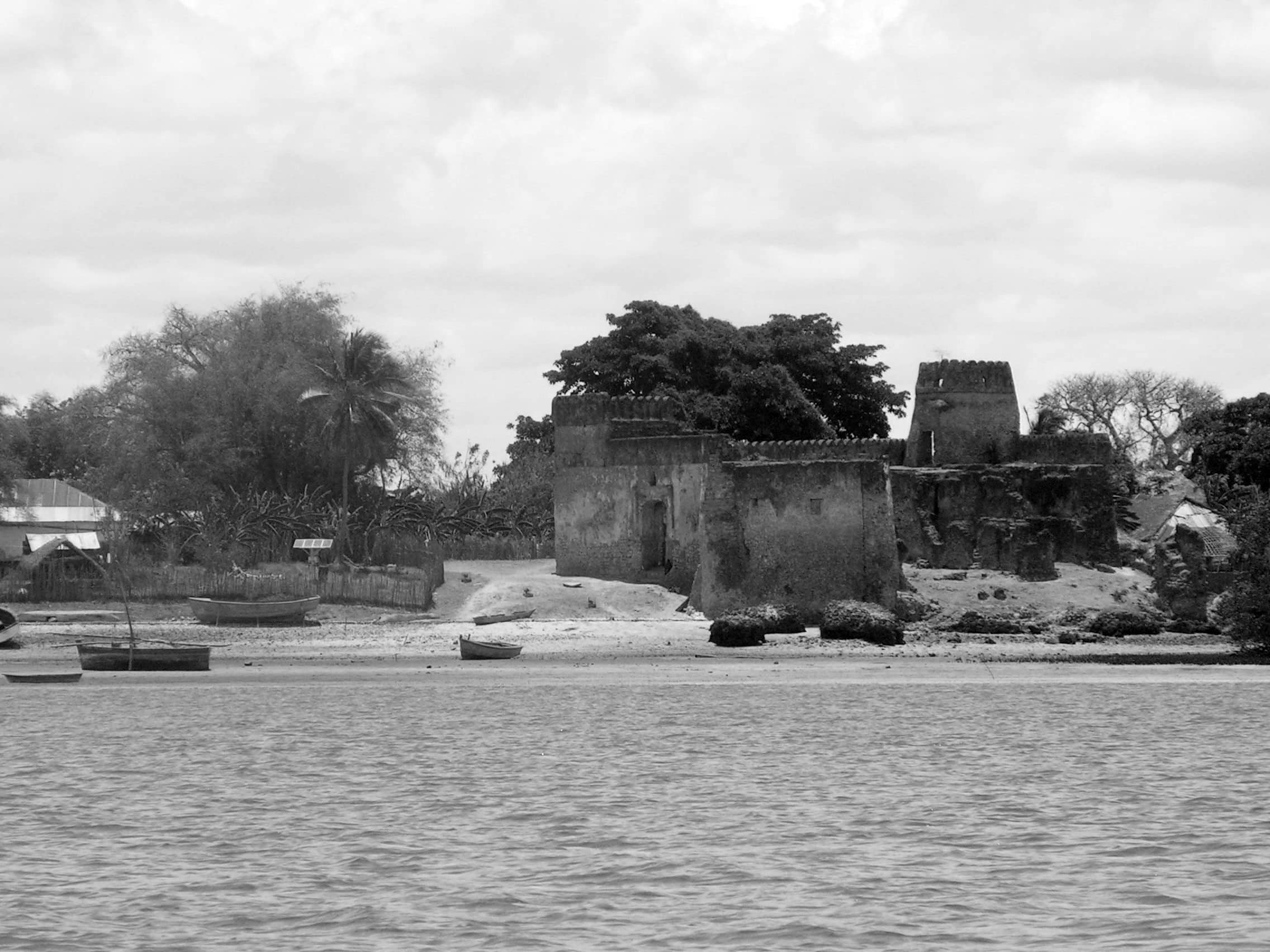
Portuguese Fort (Gereza)
In the course of their brief stay at Kilwa Kisiwani between 1505-1512CE, the Portuguese built the Gereza fort as a church based on the word ‘Igreja’. In the 16th century, the Omanis later fortified the church upon the departure of the Portuguese. In Swahili, the Gereza word means prison which indicates Omani’s use of the fort as a building for holding slaves. This occurred during the late 16th century up to the late 19th century following the downfall of the Swahili civilization after the Portuguese came in the late 16th century.
Controversies About Kilwa Kisiwani CIV 6
In the 19th century, European colonial administrators and Omani wrote and politicized the historical origins of Kilwa Kisiwani to provide a justification for the occupation and control of East Africans over hundred years ago. This has therefore led to the assumption that historical development and cultural innovation of the African continent can only come outside. As a result, there has been several contradictions in the history of Kilwa Kisiwani as regards the role and origins of foreign immigrants.
In the 11th century, the oral tradition of the local natives of Kilwa Kisiwani reveals that the island was bought by Ali ibn Hasan, who was a prince of Persia and son to King Shiraz. Some other traditions believed that Somali was his mother. The founder of the island is therefore known to be Ali ibn Al-Hasan who married the local king’s daughter. Although known as the founder, the island city was already inhabited at the time he arrived to it. Nevertheless, he rose to power and is known to have fortified the island and developed trade boom. Based also on tradition, the child of the marriage between Al-Hasan and the local king’s daughter is known to have founded the Kilwa Sultanate. In the centuries that followed, historical and documentary research reported the growth of Kilwa Kisiwani into a booming and leading commercial city on the southern part of the coast of Swahili, which is located roughly from the Tanzania-Kenya border southward to the mouth of the Zambezi River. The commercial entrepot is known to trade substantially with Southeast African States hinterland as far as Zimbabwe. The major goods traded at the time were gold, ivory, iron, jewelry, textiles, porcelain, spices and beads from Asia. There is in fact no evidence that the Shirazi-based Shia Islam was present in Kilwa Kisiwani and in the whole of the coast of East Africa.
Kilwa Kisiwani had become the most powerful island city on the coast of Swahili by the 12th century, under the dynasty of Abu’-Mawahib. In the 15th century, the Kilwa Sultanate while at the peak of its power gained control over the city-states of Zanzibar, Comoro, Malindi, Sofala, Mafia Island, Mvita (Mombasa), as well as the trading posts across the Madagascar channel.
Around 1331, Ibn Battuta visited the Kilwa Kisiwani and gave favourable comments on the goodness, humble spirit and religion of Sultan Al-Hasan ibn Sulaiman, the then ruler of the city. Further description was given by Ibn Battuta on how the sultan would raid the people in the interior and take away slaves and other means of wealth and riches. Ibn Battuta was also impressed by the city plan and was of the belief that that was the reason behind the success of Kilwa Kisiwani along the coast. This period also witnessed the building of the Palace of Husuni Kubwa and a massive extension to the Great Mosque of Kilwa which is known to be the largest mosque of its kind built with coral stones. The island city was also particularly known for being wealthy because of the trade of gold. Thus, people living in Kilwa Kisiwani are known to have a higher living standard, although the city still had some poor people too. While the poor resided in huts made with mud and thatched roofs, the rich enjoyed indoor plumbing in their stone houses.
Vasco da Gama was known to have extorted tribute from rich Islamic states in the early part of the 16th century. Another Portuguese force led by D. Francisco de Almeida dominated the island after besieging it in 1505. Kilwa Kisiwani continued to remain in the hands of the Portuguese people, until 1512 when an Arab mercenary captured the island following the abandonment of the outposts of the Portuguese. Although Kilwa Kisiwani recovered some of its prosperity, the Omani rulers of Zanzibar subsequently conquered the city in 1784. A fort was built and manned by the French people following the Omani conquest, but Kilwa Kisiwani became abandoned in the 1840s. From 1886 to 1918, the island city was made part of the colony of German East Asia.
Health and Education
Kilwa Kisiwani has only one school called the Iyahi Koranic Middle School since it has a resident population of less than a thousand people. For further education, students in advanced level move to the mainland. Since the island lack basic healthcare facilities and resources, the residents use boats to go to the mainland to receive healthcare services either at the Masoko Bakwata Dispensary or the Masoka Urban Health Center, which are both located in Masoko town in Kilwa Kisiwani.
Other Things to Know About Kilwa Kisiwani
Kilwa Kisiwani Map
Kilwa Kisiwani hotels – Tripadvisor Kilwa Island
For more articles related to regions of Tanzania click here!


 is an island, hamlet community and archaeological site situated in the Kilwa Mas...Read more!)