


")


Lindi Region – Districts, Geography, Demography, Economy and More
Tanzania has 31 administrative regions, and the Lindi Region is one of them. It is home to the Selous Game Reserve and Kilwa Kisiwani, both UNESCO World Heritage Sites. The Lindi municipality is its regional capital. According to a 2012 poll, the region had 864,652 residents, which was less than the estimated number of 960,236. During the 2002-2012 period, the average yearly populace growth in the region was 0.9%. This rate ranked 29th in Tanzania. The region also had 13 people per sq km, making it the least compact region.
Geography
Geology and Terrain
The Lindi Region covers approximately 7.1% of Tanzanian ground, making it one of the largest in the country. It covers a 66,040 sq km area. This region is larger than the Sri Lanka Islands, which only covers a 62,732 sq km area. It borders the Morogoro, Mtwara, Ruvuma, and Pwani Regions.
Much of Lindi’s western side forms the Selous Game Reserve and Nyerere National Park. These cover 27% of Lindi’s ground in total. This coverage is comparable to the nation of Kuwait’s size at 18,000 sq km. Lindi Bay, which is also in the region, is one of the largest in Tanzania.
Fauna and Flora
The Lindi Region has both Indian Ocean and African savanna fauna. The Malachite Kingfisher is the region’s regional bird and is found in large numbers throughout the Nyerere National Park and Selous Game Reserve areas.
The Tamarind tree grows abundantly in the region and is cultivated alongside cashew trees. The Ebony and Miombo trees are native to the area. Other common savanna flowers are found in bordering areas and countries.
Climate
Tropical savanna temperatures reign in the Lindi Region. It has been awarded a Köppen climate classification of 49 and Aw. The region has yearly precipitation measurements of 750 – 1200 mm and a wet season from February to March. The Nanchingwea district has a lower average monthly temperature of 22.2oC, and the coastal Kilwa Mosoka area has a monthly average of 27.7oC.
Demographics
Population
Five native ethnic communities reside in the Lindi Region. In 2012, the region had an estimated populace of 864,652 and density levels of only 51 individuals per sq km. The region is the ancestral home of the Mwera tribe, mainly located in the Kilwa district and along the central east coastline of the Lindi Region.
Other groups located in the Lindi Region include:
- The Ngindo people mainly located in the Liwale district.
- The Machinga people (minority group) mainly located in the Kilwa district
- The Makonde people mainly located in the southeast corner of the Lindi Region
- The Matumbi people mainly located in the north of the Lindi Region, which borders the Pwani Region
The lifespan of people in the Lindi Region averages 63.8 years.
Religious and Secular Communities
Sunni Islam combined with parts of African Traditional Faiths is mainly practiced in the Lindi Region. Islam was introduced to the Lindi Region via its coast during the 9th and 10th centuries when the Swahili‘s reigned.
There is a noteworthy Christian populace, although they are small.
Various ethnicities are found in urban areas like Kilwa Masoko, Lindi town, and Liwale town. A small Arab and Indian immigrant group is included herein.
Future Estimates
Godfrey Zambi is the Lindi Region’s regional commissioner.
The region is growing at 0.9% each year, which is slow compared to other areas. In 2019, the area’s populace was 1,004,439. The current growth rate estimates that the 2025 populace will have only increased by 54,240 residents.
Economy
Agriculture
The agricultural sector provides the Lindi Region with the majority of jobs. It is divided into two agro-ecological segments: a coastal zone (where tree crops like Coconut, Mango, and Cashew are mainly cultivated) and the midlands (where crops like African rice, Cassava, Maize, and Sesame is mainly cultivated).
The coastal zone stretches over the Kilwa and Lindi districts and has a height of 0 – 400 m. Commercial cashews intended for export are grown by approximately 10% of the area’s farmers.
The midlands cover the Nachingwea and Liwale districts and have a height of 300 – 900 m.
The Lindi Region still has low numbers of livestock rearing compared to other areas.
Forestry and Fisheries
With a forestry coverage of 57.17%, the Lindi Region is one of the most stocked areas in the country. Of this coverage, 38% extends over the Selous Game Reserve and Nyerere National Park grounds. A further 12% is controlled under village forest reserves, and 6% forms part of the National Forest Reserves. The government is also exploring the commercial interest for the production of sustainable honey in the forest reserves.
At 287 km long, the Lindi Region has the longest shoreline and some of Tanzania’s most abundant fish supplies. The majority of fishing vessels registered in the area are Dhows and Dugout canoes. In total, over 2,430 watercrafts are registered to more than 22,523 fishers. There are 28 fishing groups in the region, with six existing in the Kilwa area, eight in the Lindi area, and 14 in Lindi Town. The area also has significant aquaculture with 148 freshwater and 125 saltwater fish mills.
Mining and Natural Gas
Salt mining is locally done in the Lindi Region, principally in the Kilwa sector. The Kilwa district also has high-quality Gypsum accumulations near the Kiranjeranje ward. Graphited accumulations are found in the Ruangwa sector. The Songo island located in the Kilwa sector contains natural gas reserves occupying fifty-five trillion cubic feet of space. By 2019, 60 exploration wells were drilled in this area.
Tourism
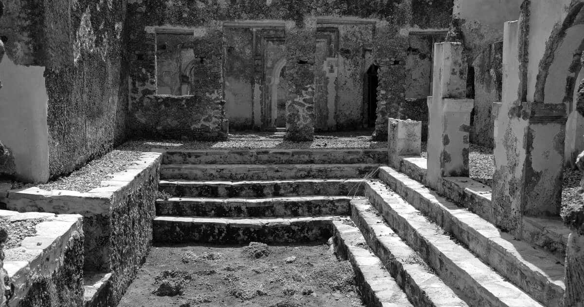
The Lindi Region offers a range of tourist attractions. Besides the Selous Game Reserve and ruins of Songo Mnara and Kilwa Kisiwani, the region also has cultural and historical attractions, wildlife safari tourism, and sun and sand tourism. In the Kilwa District near the Matumbi hills, the unexplored Nangoma cave system is also situated.
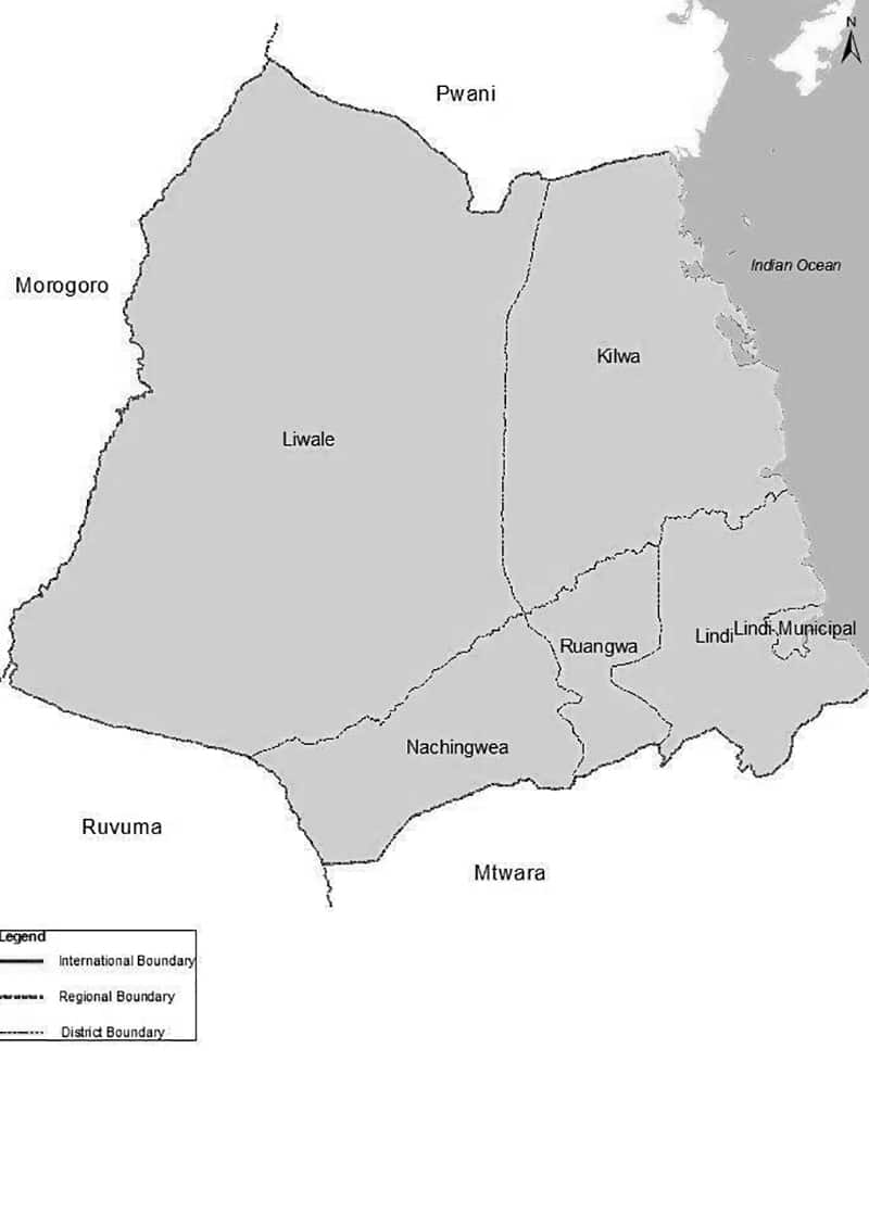
Districts
The region is divided into five administrative districts:
| LINDI REGION DISTRICTS | |||
| MAP | DISTRICT | POPULACE
(2012) |
|
| Kilwa | 190,744 | ||
| Lindi | 272,984 | ||
| Liwale | 91,380 | ||
| Nachingwea | 178,464 | ||
| Ruangwa | 131,080 | ||
| TOTAL | 864,652 | ||
Lindi Region Map
For more articles related to regions of Tanzania click here!


