


")


Critical Details About Crater Camp Kilimanjaro Routes
You won’t find another place like Crater Campground. It is Mount Kilimanjaro’s highest campsite at 18,865 feet above sea level. Only 475 feet separate it from the summit. Crater Camp Kilimanjaro is an option on the Lemosho and Northern Circuit excursions. The nine-day Lemosho Crater Route and the ten-day Northern Crater Route can be extended by one day with the possibility of staying here.
During the day, we go to the top and return to Crater Camp to adjust and normalize ourselves to the altitude. Only the guides and clients reach the summit on all other Kilimanjaro routes, while the rest of the mountain team remains in the high campground on Barafu. A considerable increase in effort is required on our part because the entire mountain crew, along with all the expedition’s equipment, must ascend 4,000 feet higher than they would normally. As a result, the Crater Camp approach comes at a hefty premium price.
At Kilimanjaro crater camp, tourists can make the one-hour ascent to Reusch Crater or explore the area around Furtwangler Glacier. Visiting Reusch Crater is a breathtaking experience. It’s virtually circular, measuring 1,300 feet in width and 400 feet in depth. Tourists rarely get a chance to view this. See the video below to get an idea of the ash hole and crater’s size.
Crater Campsite’s allure is well-grounded, and we can see why. The dangers of sleeping at this altitude cannot be overstated. Severe AMS can occur when altitude acclimation is inadequate; see why on: Should We Sleep at Crater Camp?
Ultimate Kilimanjaro can deny access to the nine-day Lemosho Crater Route or the ten-day Northern Crater Route due to safety concerns for customers and personnel.
The Nine-Day Lemosho Crater Camp Kilimanjaro Travel Plan
On the First Day:
Ascending Londorossi Gate Way to Mti Mkubwa
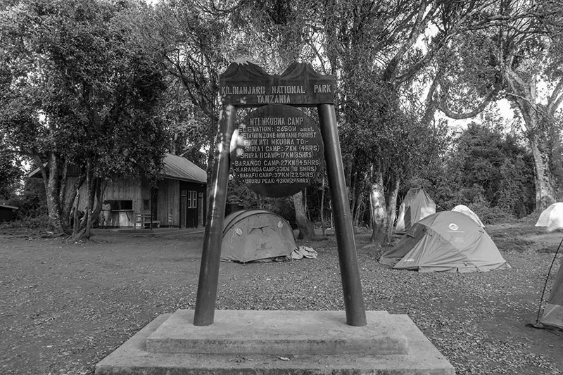
- Hiking an elevation of 7,742 to 9,498 feet above sea level.
- Covering a six-kilometer distance, or four miles.
- Three to four hours of hiking time is required.
- Located in a rainforest habitat.
We begin from Moshi and arrive at Londorossi Gate, where you must complete entry formalities after a four-hour journey. Then proceed to the Lemosho crater camp Kilimanjaro course. We stroll through gorgeous woodland from the route to get to our first camping spot.
On the Second Day:
Ascending Mti Mkubwa to Shira Camp One
- Hiking an elevation of 9,498 to 11,500 feet above sea level.
- Covering an eight-kilometer distance, or five miles.
- Five to six hours of hiking time is required.
- Located in a heath habitat.
A short distance farther brings us to an open savannah of heather, volcanic rocks, and tall grasses covered in lichen beards. We traverse gorgeous rolling hills and cross multiple creeks before reaching Shira Ridge and Shira Camp One. From this vantage point, we get our first glimpse of Kibo.
On the Third Day:
Ascending Shira Camp One to Moir Hut
- Hiking an elevation of 11500 to 13800 feet above sea level.
- Covering an eleven-kilometer distance, or seven miles.
- Five to seven hours of hiking time is required.
- Located in a heath habitat.
The Shira Plateau takes up the majority of our day. Shira Camp Two can be reached by a delightful walk east through moorland meadows. To get to Moir Hut, a seldom-visited stop at the base of Lent Hills, we have to divert from the main trail again. If you’re looking for a way to get used to the altitude, Lent Hills is an excellent option. When talking about the world’s highest plateau, the Shira Plateau is number one.
Crater Camp Kilimanjaro; Fourth Day
Ascending Moir Hut to Lava Tower
- Hiking an elevation of 13800 to 15190 feet above sea level.
- Covering a seven-kilometer distance, or four miles.
- Four to five hours of hiking time is required.
- Located in an alpine desert.
Descending from Lava Tower to Barranco Campground
- From an altitude of 15,190 to 13,044feet.
- Covering a distance of three kilometers or two miles.
- Two to three hours to go hiking is required.
- Located in an alpine desert.
On our trip to the Lava Tower, a 300-foot-tall volcanic rock formation, we ascend a mountain first. The Senecio Forest, which reaches an altitude of 13,000 feet, is our route to Barranco Camp. It is essential to spend some of your days at a higher altitude than you usually would to aid in acclimatization.
Crater Camp Kilimanjaro; Fifth Day
Ascending Barranco Campground to Karanga Campground
- Hiking an elevation of 13,044 to 13,106 feet above sea level.
- Covering a five-kilometer distance, or three miles.
- Four to five hours of hiking time is required.
- Located in an alpine desert.
We begin our day by descending into a gully to the Great Barranco Wall’s base. A non-technical but about 900-foot steep climb awaits us next. From the crest of the Barranco Wall, we soon drop into Karanga Valley. Karanga Camp is our final destination after a grueling ascent. This is a shortened day to help with the adjustment process.
On the Sixth Day:
Ascending Karanga Campground to Barafu Campground
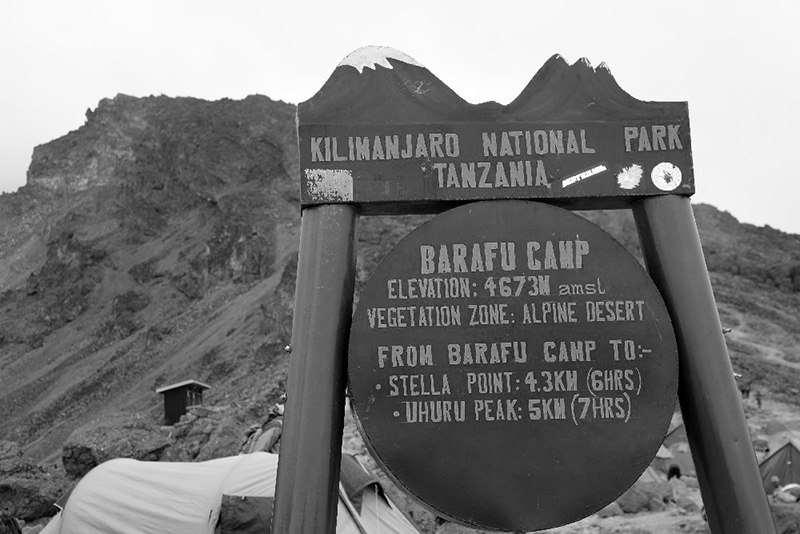
- Hiking an elevation of 13,106 to 15,331 feet above sea level.
- Covering a four-kilometer distance, or two miles.
- Four to five hours of hiking time is required.
- Located in an alpine desert.
At the Mweka Trail’s intersection, we leave Karanga. The rocky section going to Barafu Hut is our next objective. You’ve now completed the Southern Course Circuit, which offers a variety of vantage locations for taking in the vista from the peak. On the eve of the summit day, we’ll pitch up camp, rest, and eat an early dinner here. The two peaks of Mawenzi and Kibo can be seen from here.
Crater Camp Kilimanjaro; Seventh Day
Ascending Barafu Campground to the Mountains Uhuru Peak
- Hiking an elevation of 15,331 to 19,341 feet above sea level.
- Covering a five-kilometer distance, or three miles.
- Seven to eight hours of hiking time is required.
- Located in an arctic habitat.
Descending Uhuru Peak from Crater Campground
- From an altitude of 19,341 to 18,865 feet.
- Covering a distance of One kilometer or o.6 miles.
- 0.5 to One hour to go hiking is required.
- Located in an arctic habitat.
By daybreak hours, we begin our ascent. This is the most physically and mentally challenging part of the expedition. Slowly but steadily, we make our way up the mountain for several hours, halting frequently but briefly. The pathway becomes a thick blanket of scree as we near the crater’s rim. In the distance, sights of the summit can be seen at 18,900 feet. At the top of Mount Kilimanjaro’s crater rim, known as Uhuru Peak, we can see all of Africa.
After that, we’ll make our way to Crater Campground, where the rest of the team will meet us to begin camp setup. Reutsch Crater, the ash pit, and investigating the area near Furtwangler Glacier are possibilities. It’s risky to sleep at such a high altitude. If you don’t get adequate altitude acclimatization, you could suffer from severe Acute mountaineering sickness, so your guides will keep monitoring you.
On the Eighth Day:
Descending the Crater Camp Kilimanjaro to the Mweka Campground
- Hiking an elevation of 18,865 to 10,065 feet above sea level.
- Covering a twelve-kilometer distance, or seven miles.
- Four to six hours of hiking time is required.
- Located in an arctic habitat.
Now that we’ve left Crater Campground, we’ll be heading straight to Mweka Hut’s Campground; at Barafu is where we’ll be stopping for lunch. Trekking poles are highly suggested because the terrain is quite rocky and challenging on the knees. Mweka Campground is located in the upper woodland; late afternoon mist or rain is often expected. We finish the day with one last lunch on the mountain top before taking a well-deserved snooze to prepare us for the next day.
On the Ninth Day:
Descending Mweka Campground to the Mweka Gate
- Hiking an elevation of 10,065 to 5,380 feet above sea level.
- Covering a ten-kilometer distance, or six miles.
- Three to four hours of hiking time is required.
- Located in a rainforest habitat.
We’ll make our way back to Mweka Gate to pick up our summit credentials for recognition on our last day. Lower elevations often have rain and sludge, with Mweka Village being another hour’s drive from the gate. We’ll be picked up at Mweka Village and taken back to our accommodation in Moshi by a van.
The Ten-Day Northern Crater Camp Kilimanjaro Travel Plan
On the First Day:
Ascending Londorossi Gate Way to Mti Mkubwa
- Hiking an elevation of 7,742 to 9,498 feet above sea level.
- Covering a six-kilometer distance, or four miles.
- Three to four hours of hiking time is required.
- Located in a rainforest habitat.
We begin from Moshi and arrive at Londorossi Gate, where you must complete entry formalities after a 4-hour journey. Then proceed to the Lemosho course. We stroll through gorgeous woodland from the pathway to get to our first camping spot.
On the Second Day:
Ascending Mti Mkubwa to Shira Camp One
- Hiking an elevation of 9,498 to 11,500 feet above sea level.
- Covering an eight-kilometer distance, or five miles.
- Five to six hours of hiking time is required.
- Located in a heath habitat.
A short distance farther brings us to an open savannah of heather, tall grass, and volcanic rock covered in lichen beards. We traverse gorgeous rolling hills and cross multiple creeks before reaching Shira Ridge and Shira Camp One. From this vantage point, we get our first glimpse of Kibo.
Crater Camp Kilimanjaro; Third Day
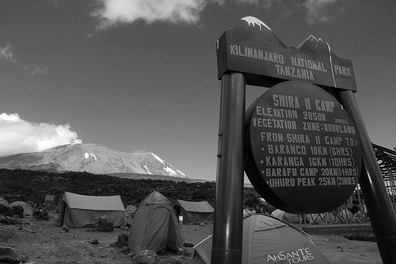
Ascending Shira Camp One to Shira Camp Two
- Hiking an elevation of 11500 to 12500 feet above sea level.
- Covering a seven-kilometer distance, or four miles.
- Three to four hours of hiking time is required.
- Located in a heath habitat.
The Shira Plateau is our next stop. Shira 2 Camp can be reached by a delightful walk east through moorland meadows. Wildflowers and one-of-a-kind Senecio trees are found in abundance in this heath zone.
On the Fourth Day:
Ascending Shira Camp Two to Lava Tower
- Hiking an elevation of 12500 to 15190 feet above sea level.
- Covering a seven-kilometer distance, or four miles.
- Three to four hours of hiking time is required.
- Located in an alpine desert.
Descending from the Lava Tower to Moir Hut
- From an altitude of 15,190 to 13,580feet.
- Covering a distance of seven kilometers or four miles.
- Two to three hours to go hiking is required.
- Located in an alpine desert.
Our next destination is the Lava Tower, a 300-foot-tall volcanic rock formation. To get to Moir Hut, a seldom-visited stop at the base of Lent Hills, we have to divert from the main track again. If you’re looking for a way to get used to the height, Lent Hills is an excellent option. When it comes to the world’s highest plateau, the Shira Plateau is one.
Crater Camp Kilimanjaro; Fifth Day
Descending Moir Hut to Buffalo Campground
- Hiking an elevation of 13,580 to 13,200 feet above sea level.
- Covering a twelve-kilometer distance, or seven miles.
- Five to seven hours of hiking time is required.
- Located in an alpine desert.
Leaving Moir Valley, we begin our walk with a moderately steep ascent, followed by a steep climb to the top of Lent Hills. Buffalo Camp can be found at the trail’s end, which meanders through a rock field. The plains north of Kilimanjaro reach the Kenyan and the Tanzanian border from this section of the course.
On the Sixth Day:
Descending Buffalo Campground to the Third Cave
- Hiking an elevation of 13,200 to 12,700 feet above sea level.
- Covering an eight-kilometer distance, or five miles.
- Five to seven hours of hiking time is required.
- Located in a heath habitat.
On Buffalo Ridge, the landscape becomes increasingly lonely as we climb higher. We’ll enjoy the wild feel of the mountains on this route, which is rarely traveled. Finally, we arrive at Third Cave on Kilimanjaro’s northern slopes.
On the Seventh Day:
Ascending Third Cave to the School Hut
- Hiking an elevation of 12,700 to 15,600 feet above sea level.
- Covering a five-kilometer distance, or three miles.
- Four to five hours of hiking time is required.
- Located in an alpine desert habitat.
From Kibo to Mawenzi, we must pass over the “Saddle,” gradually elevating our hikes. We continue our Crater Camp Kilimanjaro journey to School Hut, our campsite, where we spend the night. After arrival, we rest, eat, and prepare for our busiest day of the week.
On the Eighth Day:
Ascending School Hut to the Mountains Uhuru Peak
- Hiking an elevation of 15,600 to 19,341 feet above sea level.
- Covering a six-kilometer distance, or four miles.
- Six to eight hours of hiking time is required.
- Located in an arctic habitat.
Descending the Uhuru Peak from Crater Camp Kilimanjaro
- From an altitude of 19,341 to 18,865 feet.
- Covering a distance of One kilometer or o.6 miles.
- 0.5 to One hour to go hiking is required.
- Located in an arctic habitat.
By dawning hours, we begin our ascent. This is the most physically and mentally challenging part of the course. Slowly but steadily, we make our way up the mountain for several hours, halting frequently but briefly. The pathway becomes a thick blanket of scree as we near the crater’s rim. From Gilman’s Point, we can see the summit sign at 18,600 feet. At the top of Mount Kilimanjaro’s crater rim, known as Uhuru Peak, we can see all of Africa.
After that, we’ll make our way to Crater Campground, where the rest of the team will meet us to begin setting up camp. Reutsch Crater and the ash pit are up for investigation; the area near Furtwangler Glacier is also possible. It is risky to sleep at such a high altitude. If you don’t get adequate altitude acclimatization, you could suffer from severe sickness from altitude mountaineering, so your guides will keep an eye on you.
On the Ninth Day:
Descending Crater Camp Kilimanjaro to the Mweka Campground
- Hiking an elevation of 18,865 to 10,065 feet above sea level.
- Covering a twelve-kilometer distance, or seven miles.
- Four to six hours of hiking time is required.
- Located in an arctic habitat.
Now that we’ve left Crater Camp, we’ll be heading straight to Mweka Hut, but first at Barafu, where we’ll be stopping for lunch. Trekking poles are highly suggested because the terrain is quite rocky and challenging on the knees. Mweka Camp is located in the upper woodland with expectations of late afternoon mist or rain. We finish the day with one last lunch on the cliff top before taking a well-deserved snooze to prepare for the next day.
On the Tenth Day:
Descending Mweka Campground to the Mweka Gate
- Hiking an elevation of 10,065 to 5,380 feet above sea level.
- Covering a ten-kilometer distance, or six miles.
- Three to four hours of hiking time is required.
- Located in a rainforest habitat.
We’ll make our way back to Mweka Gate to pick up our summit credentials on our last day; lower elevations may have rains and sludge. Mweka Village is another hour’s drive from the gate. We’ll be picked up at Mweka Village and taken back to our accommodation in Moshi by a van.
For more articles related to Things to Do in Tanzania (Zanzibar), click here!


