


")


Ngorongoro Conservation Area Tanzania – Crater, Geology, Olduvai, Wildlife and More
The Ngorongoro Conservation Area is a preserved area as well as a World Heritage Site situated 180 kilometers (110 miles) in the west of Arusha in Tanzania’s Crater Highlands. The name of the place is from Ngorongoro Crater, a huge volcanic caldera in the area. Ngorongoro Conservation Area Authority (NCAA), an arm of the government of Tanzania, administers the conservation area, with its boundaries following the Ngorongoro Division boundary in Arusha Region.
Ngorongoro Conservation Area Act of 2009 put new restrictions regarding human settlement plus subsistence cultivation in the Crater, relocating Maasai pastoralists, many of whom had been resettled to Ngorongoro Conservation Area from their traditional lands in the north by the colonial government of the British after the 1959 establishment of Serengeti National Park.
Background and Geography of the Serengeti National Park and Ngorongoro Conservation Area in Tanzania
Maasai Ngorongoro Conservation Area connection – The crater’s name originates from a sound; Maasai pastoralists named it after the cowbell’s (ngoro ngoro) sound. According to fossil evidence discovered at Olduvai Gorge, many hominid species have inhabited the place three million years back.
Pastoralists replaced hunter-gatherers some thousand years back. The Mbulu inhabited the area around 2,000 years back, joined by the Datooga about the year 1700. The Maasai people chased the two groups from the site in the 1800s.
Not until 1892, there’s no record of European settlement in the Ngorongoro Crater, with the arrival of Oscar Baumann. Before World War I broke out, two brothers from Germany ( Friedrich and Adolph Siedentopf) cultivated in the crater, after administrators of German East Africa leased them land. The brothers usually organized shooting expeditions to please their friends from Germany. They also tried to drive herds of the wildebeest away from the crater.
The passing of the initial game preservation ordinance in 1921 prohibited hunting without a permit throughout Tanzania. By 1928, hunting was outlawed throughout areas in the crater’s rim, apart from what used to be the Siedentopf farms. In 1948, the National Park Ordinance (put into effect in 1951) formed the Serengeti National Park (SNP). However, this created conflicts with the Maasai and surrounding tribes, leading to the 1959 Ngorongoro Conservation Area Ordinance that split the national park and the conservation area. Maasai pastoralists who inhabited Serengeti National Park relocated systematically to Ngorongoro, growing the Maasai population and livestock inhabiting the crater.
Establishment of NCAA by the Game Park Laws (miscellaneous amendments) Act of1976, with ownership of the biggest portion of land in the Ngorongoro Conservation Area, where the crater is. In 1979, the place was made a UNESCO World Heritage Site. The Wildlife Conservation Act, 2009, further prohibited human utilization of Ngorongoro Crater with creating a legal structure to deprive and force displacement of traditional pastoralists politically. Land use restriction generated conflict between the native Maasai societies and conservation officials. International Union for Conservation of Nature (IUCN) seeks solutions to lessen conflict and enhance collaborative efforts regarding conservation with local peoples.
The Ngorongoro Conservation Area land is for multiple uses and unique for being Tanzania’s only conservation area for protecting wildlife as well as allowing human habitation. Control of land use prevents adverse effects on flora and fauna. For example, the growing of food crops is limited to subsistence levels.
Serengeti ecosystem owns the area adjoining the SNP in the northwest while sharing a border with the Serengeti plains in the south. These plains extend further in the north reaching the vulnerable Loliondo division while being accessible by wildlife through the Maasai’s transhumance pastoralism practices. Volcanic highlands are in southern and western parts, including the renowned Ngorongoro Crater as well as the insignificant Empakaai Crater. The rim of the East African Rift Valley wall defines the boundaries in the south and east, preventing animal migration in these directions.
Things to Do in Ngorongoro Conservation Area
The following is a list of things to see and explore if you opt to take the Ngorongoro Conservation Area safari:
Geology of Ngorongoro Conservation Area
Ngorongoro’s Pliocene volcanic group includes 8 extinct broad domed volcanoes in the Eyasi half-graben, Gregory Rift’s western escarpment takes up the eastern boundaries. Lake Eyasi escarpment borders the half-graben in the southwest. In the complex, 5 volcanoes have dome-shaped cones, with three having calderas. Ngorongoro Volcano (2.5–1.9 Ma) is mainly basaltic trachyandesite.
Oljoro Nyuki and Munge Rivers feed the caldera, and the Ngoitokitok hot springs drain Goringop swamp. Magadi is a shallow (1. metre) alkaline lake. More volcanoes in the complex are Sadiman (3.7 Ma), Empakaai, Olmoti (2.01–1.79 Ma), Loolmalasin, Oldeani, and Lemagrut. The conservation area’s northwest part includes Salei Plains, Serengeti Plains, Gol Mountains inselbergs, and Oldupai Gorge. The inselbergs belong to the Mozambique Belt mica schist and quartzite aged around(800–500 Ma).
Ngorongoro Crater Conservation Area Tanzania
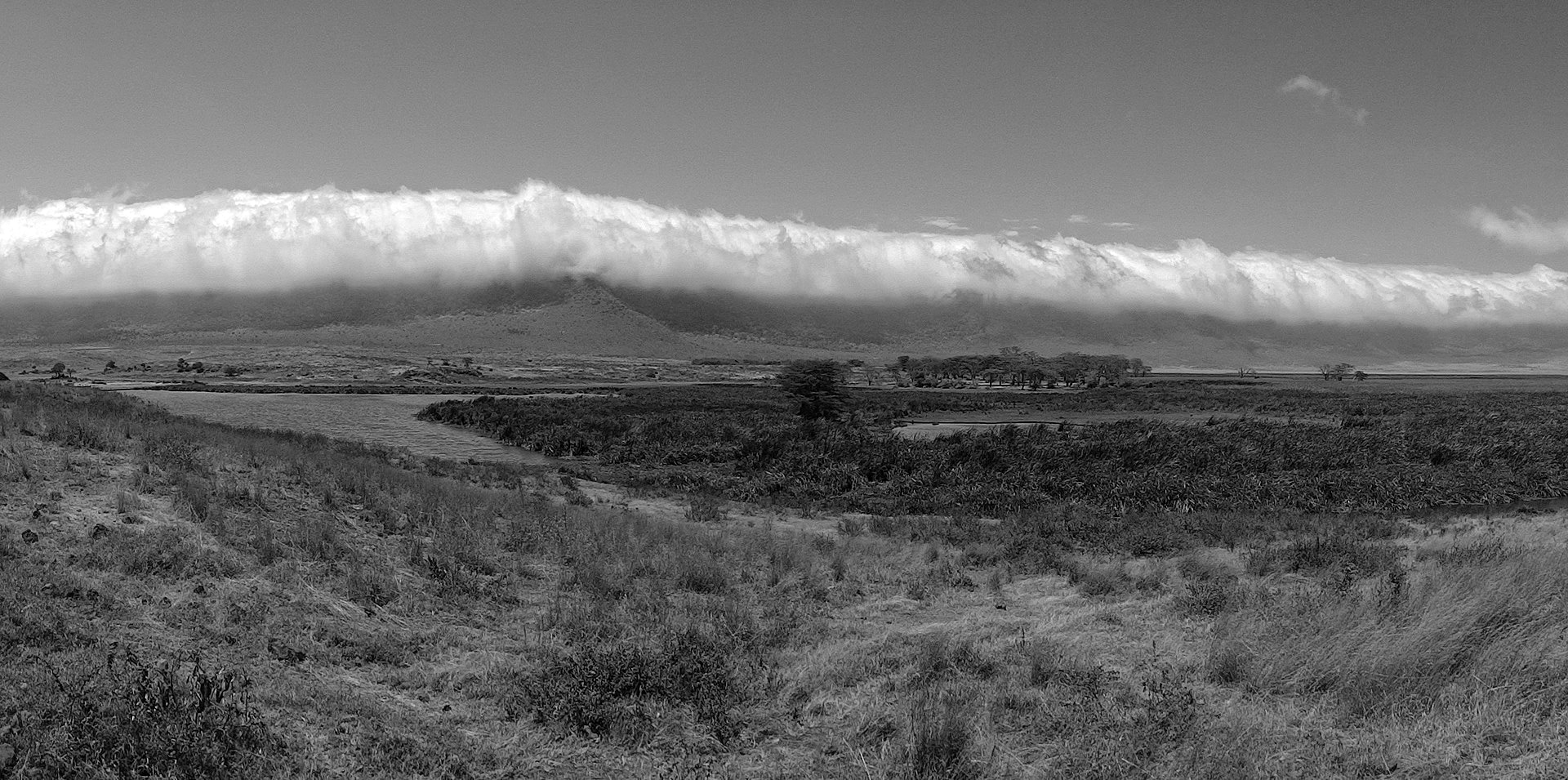
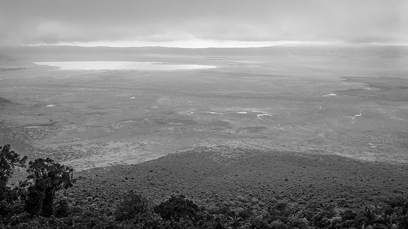
Ngorongoro Crater is the Ngorongoro Conservation Area Authority’s prominent feature, the largest inactive, unfilled, and intact volcanic caldera globally. The crater formed after a giant volcano explosion and fell on itself about two to three million years back has a depth of 610 metres (2,000 feet) floor covering 260 kilometres (100 miles squared).
The height estimate of the original volcano is from 4,500 to 5,800 metres (between14,800 and 19,000 feet) high. The altitude of the crater’s floor is 1,800 metres (5,900 feet). in February 2013, Seven Natural Wonders voted the crater among Seven Natural Wonders in Arusha, Tanzania. Ngorongoro volcano last exploded around 2.45 to 2 million years back.
Volcanic eruptions such as those of Ngorongoro Conservation Area, which led to Ngorongoro Crater’s formation, were popular in Tanzania. Matching collapses happened in Empakaai and Olmoti, but were less significant in impact and magnitude.
From Ol Doinyo Lengai and Kerimasi volcanoes in the Empakaai caldera’s northeast, Doinyo Lengai had a recent eruption with significant explosions in 2007 and 2008. Tiny ash eruptions with lava continuously flow slowly, filing the crater today. Its named Maasai meaning ‘Mountain of God’.
Munge Stream empties Olmoti Crater in the north and primarily drains into the periodic salt lake in the crater’s centre. The Maasai call this lake Makat, meaning salt, while others call it Magadi. Lerai Stream waters the humid forests in the crater’s south while feeding Lerai Forest on the lower surface of the crater. During periods of enough rain, Lerai drains into Lake Magadi. The utilization of water by Ngorongoro Conservation Area head office and lodges lowers the amount of water going into Lerai by about 25%.
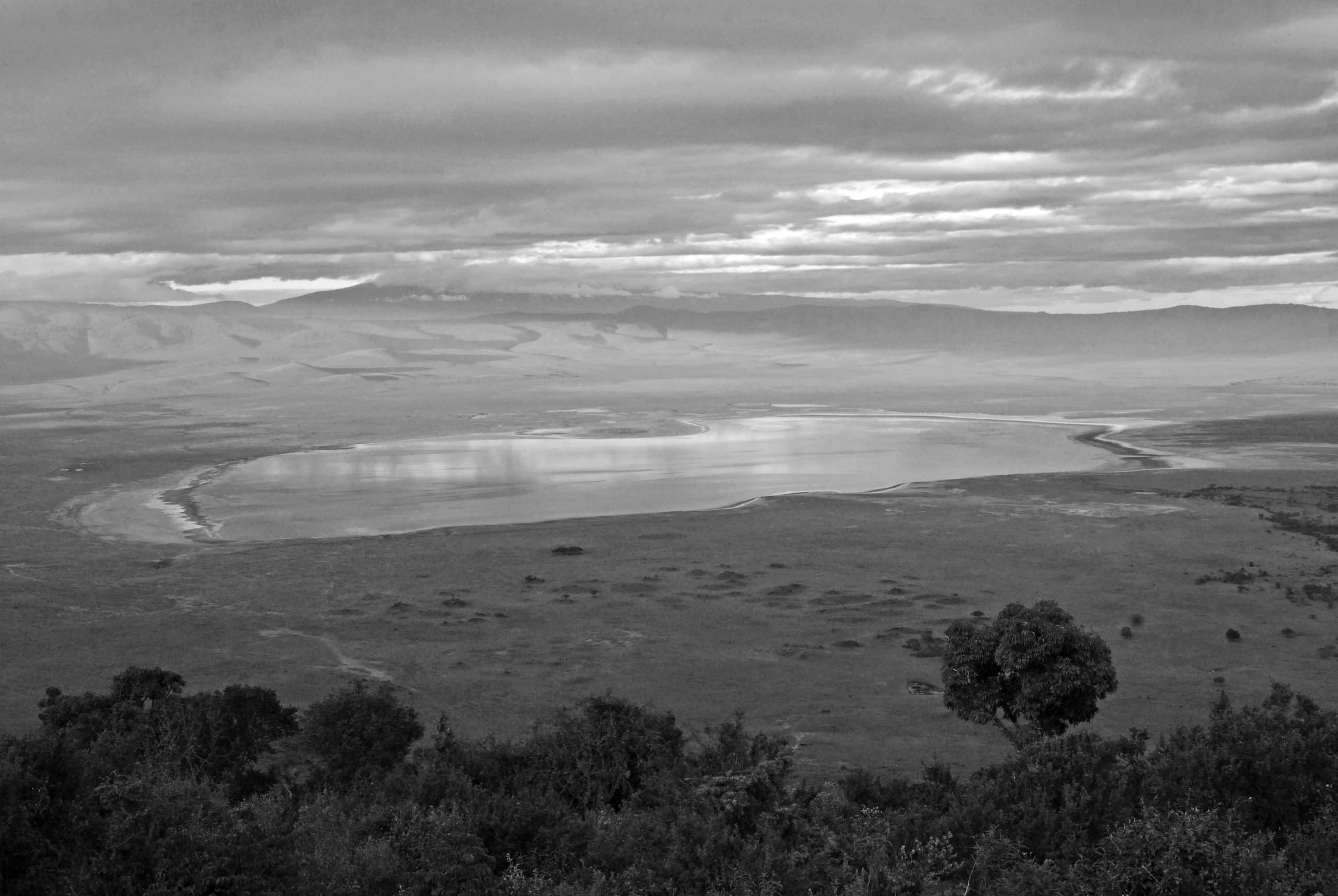
Ngoitokitok Spring is another significant source of water in the crater, near the crater’s eastern wall. A picnic site exists here to service tourists and a large swamp getting water from the spring, and lions, elephants, hippopotamuses, and different other wildlife inhabit this place. Various other tiny springs exist throughout the crater’s floor, these are essential water supply sources for animals and native Maasai, mainly during drought. Masai were earlier allowed to have their cattle graze in the crater; however, they were restricted in 2015.
Olduvai or Oldupai Gorge
Ngorongoro Conservation Area protects Olduvai or Oldupai Gorges too, located in the plains area. It’s considered the seat of humanity since the earliest known human genus specimens were discovered here, Homo habilis and early Hominidae like Paranthropus boisei.
Olduvai Gorge is in the Rift Valley with a steep-sided ravine stretching along East Africa. Olduvai is in Serengeti’s eastern plains in the north of Tanzania and stretches around 50 kilometers (31 miles) long. The gorge lies in Ngorongoro highlands’ rain shadow and is drier than other parts of the region. The gorge’s name is after ‘Oldupaai’, a Maasai word meaning wild sisal plant ( Sansevieria ehrenbergii).
Olduvai Gorge is among the world’s most important prehistoric locations, and local research has been essential in improving the study of early human evolution. Mary and Louis Leakey pioneered excavation work here during the 1950s, and their family keeps it going on today. Some think millions of years, the site was a huge lake, with shores covered with succeeding volcanic ash deposits. About 500,000 years, back seismic action diverted a stream nearby that started cutting down into the sediments, exposing 7 major layers in the gorge’s walls.
Animals of the Serengeti and Ngorongoro Conservation Area
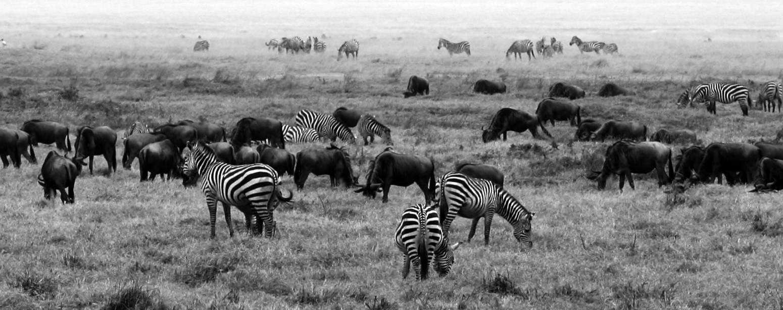
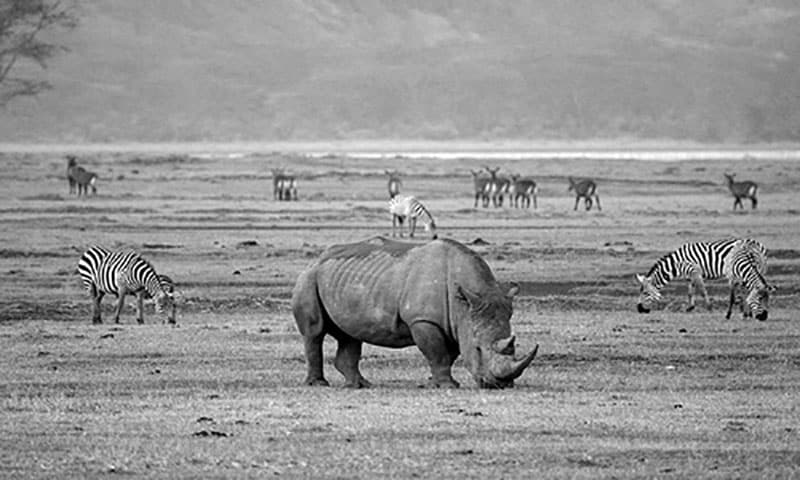
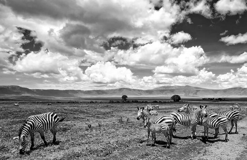
About 25,000 big animals, primarily ungulates inhabit the crater at the Ngorongoro Conservation Area. Big mammals inhabiting the crater are the hippo (Hippopotamus amphibius), African or Cape buffalo (Syncerus caffer), black rhino (Diceros bicornis michaeli), the native population declined from around 108 in 1964-66 to a range of 11–14 by 1995. There are also various other ungulates: Grant’s zebra (Equus quagga boehmi) (4,000), the blue wildebeest (Connochaetes taurinus) (7,000 predicted in 1994), Grant’s (Nanger granti) and Thomson’s gazelles (Eudorcas thomsonii) (3,000) and common eland (Taurotragus oryx), Waterbucks (Kobus ellipsiprymnus) are mostly Lerai Forest.
Not present include impala (Aepyceros melampus), Giraffe, topi (Damaliscus lunatus), crocodile (Crocodylus niloticus), oribi (Ourebia oribi).
Rarely seen are African leopard (Panthera pardus pardus, Zanzibar leopard), Cheetah (Acinonyx jubatus raineyi), and East African wild dog (Lycaon pictus lupinus). Since 1996, long-term research has been going on in the Ngorongoro Conservation Area about the spotted hyenas (Crocuta crocuta).
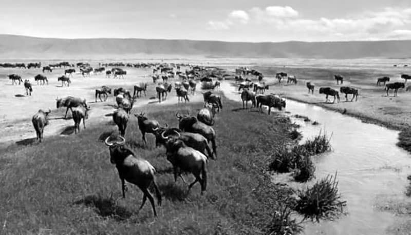
Despite the idea of being “a natural enclosure” for various wildlife varieties, half of the zebra and 20 percent or more of the wildebeest populations leave the crater during the wet season, although Cape buffalo (Syncerus caffer) keep around; their biggest numbers happen when it’s rainy season.
From 1986, the wildebeest population in the crater has dropped from 14,677 to 7,250 (between 2003 to 2005). The Thomson’s gazelle and eland populations have also declined as the number of buffalos has significantly increased, possibly because of the comprehensive fire prevention, which encourages high-fibrous grasses compared to shorter and less fibrous kinds.
Serval (Leptailurus serval) exists throughout the Ngorongoro Conservation Area crater.
Thousands of mostly lesser flamingoes usually inhabit Magadi, a lake in the southwest of the crater.
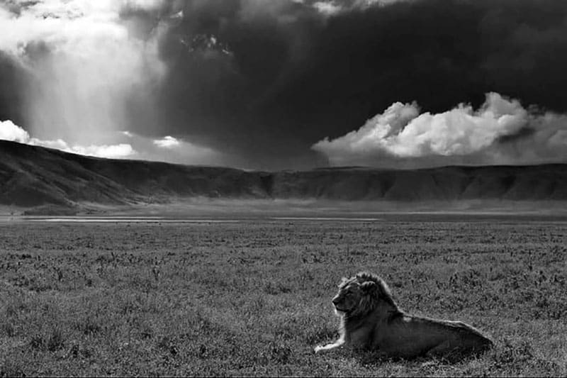
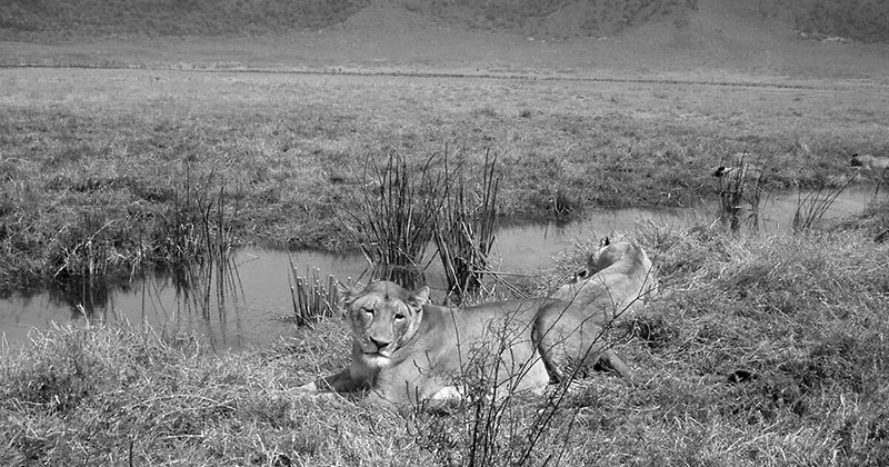
The crater is home to a dense population of lions, amounting to 62 by 2001.
An adverse effect of being an enclosure made by nature is having a significantly inbred lion population. This results from the very tiny amount of foreign bloodlines entering the native gene pool, since very few male lions migrate into the crater from other areas. Those who that the crater is usually prohibited from adding to the gene pool by male lions native in the crater, who chase any external competitors.
Data over a long period shows that the crater lions suffered four deadly disease outbreaks from 1962 to 2002. Limited water supply in 1961 with rains during the 1962 dry season led to excessive build-up of stable flies (Stomoxys calcitrans) that suck blood in May 1962. These sucked blood and painful skin sores became infected, making the lion population diminish from 12 from 75 to-100.
The numbers recovered to about 100 in 1975 and remained consistent until 1983, at the start of a persistent decline. The population has generally remained less than 60 animals from 1993, reaching just 29 by 1998. By 2001, about 34 percent of the lions died from canine distemper and tick-borne disease between January and April.
Incoming males further determine the number of lions that takeover prides, which usually kill tiny cubs. The most significant influence, however, seems to be disease, especially canine distemper.
Exterior Ngorongoro Crater
Ngorongoro Conservation Area owns a resident population of varied wildlife species in good health. Ndutu Lake area in the conservation area’s western side has incredibly, strong lion and cheetah populations. Predominant in the region are spotted hyena (Crocuta crocuta), jackal, and hartebeest (Alcelaphus buselaphus). The African wild dog population may have declined recently. Servals occur throughout the plains in the west of Ngorongoro Crater.
The wildebeest migration of ungulates annually goes through Ngorongoro Conservation Area area, including 260,000 zebra,470,000 gazelles, and 1.7 million wildebeest, southwards into the area during December as well as going northwards by June. The movement adjusts to the rain season; however, the migration goes through almost the whole plains, searching for food.
Ngorongoro Conservation Area Accommodation
Ngorongoro Conservation Area Hotels
- The highlands Ngorongoro conservation area Tanzania – https://www.asiliaafrica.com/camps-lodges/the-highlands/
- Simba campsite Ngorongoro conservation area – Simba Campsite Tripadvisor
- Ngorongoro Sopa Lodge Ngorongoro Conservation Area – Sopa Lodge
- Andbeyond Ngorongoro Crater Lodge Ngorongoro Conservation Area Tanzania – Ngorongoro Crater Lodge
For other hotels in Ngorongoro conservation area you can explore Tripadvisor.
Other Important Things to Know About the Ngorongoro
- Birds of the Serengeti and Ngorongoro conservation area – Slideshow of Serengeti and Ngorongoro birds
- Flights to Ngorongoro conservation area by Expedia
- Ngorongoro conservation area fees – Ngorongoro conservation area park fees
- Ngorongoro conservation area tour options by Tourradar.com
- Ngorongoro conservation area authority contacts:
Ngorongoro Conservation Area Authority, P O Box 1, Ngorongoro – Arusha, Tanzania Main phone: +011 255 27 253 7019, Fax Number: +011 255 27 2537007
- Ngorongoro conservation area jobs – https://jobs.tz.cari.africa/jobs/ngorongoro-conservation-area-authority
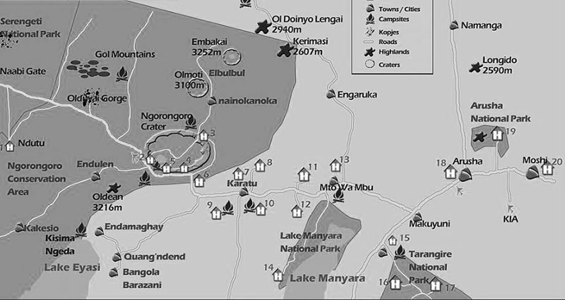
Ngorongoro Conservation Area Map
Ngorongoro Conservation Area Photos


For more articles related to Wildlife Parks in Tanzania click here!


 in the ...Read more!)