


")


Quick Snapshot of the Tanzania Kigoma Region Profile
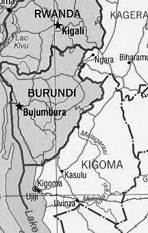
Where is Kigoma?
Kigoma Region is one of the thirty-one administrative regions in Tanzania. The city of Kigoma serves as the region’s capital. Statistics from the national census of 2012 show that Kigoma region had a total population of 2,127,930. This figure exceeded the pre-census projection of 1,971,332. Kigoma region’s 2.4% average yearly population growth rate between 2002 and 2012 was joint 14th highest in Tanzania. With fifty-seven people per square kilometer, the region was ranked the 16th most densely populated region in the country. With a size of 17,400 square miles (45,066 km2), Estonia (17,462 square miles (45,227km2))is only slightly bigger than the region.
Geography of Kigoma Tanzania
Kigoma Region is located on the northwestern edge of Tanzania on the eastern coast of Lake Tanganyika. It lies about 300 east and 50 south of Greenwich. The Kagera Region and Burundi border Kigoma Region to the north. Tabora and Shinyanga regions border it to the east; Rukwa region borders Kigoma to the east, while Lake Tanganyika, which forms a border with DR Congo, lies on its western border.
Kigoma Tanzania Weather
Kigoma weather all around the year is usually dry, accompanied with some cloudy climate and warm throughout. Temperature range is mostly between 17 degrees celcius to 30 degrees celcius and in few cases it can go below 15 degrees celcius or above 30 degrees celcius.
Kigoma region has a total area of 17,400 square miles (45,066 km2), of which 3,100 square miles (8,029 km2)is water, and 14,300 square miles (37,037 km2) is dry land. Kigoma region’s total area is only 62 square miles (161 km2) less than Estonia’s land area. As of 1998, nearly 7,700 square miles (20,000 km2) of the region were in forest areas, and 4,600 square miles (12,000km2) were ideal for farming or grazing.
Kigoma region is located on a plateau that descends from the northeast at around 5,740 feet (1,750 metres) down to 2,600 feet (800 metres) at Lake Tanganyika’s shore. The topography in the east and north consists of smoothly undulating hills that slowly become steeper as they near the margin of the Albertine Rift. The Malagarasi river is the most important river, while the Ruchugi and the Luiche are the two other rivers that drain the region.
A map showing the Malagarasi River and most of Kigoma region.
History of Kigoma Region Tanzania
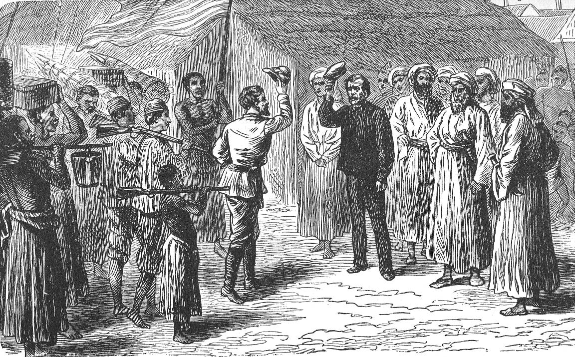
Before the advent of colonialism, the area was a source of slaves and ivory. Kigoma Ujiji Tanzania (Kigoma Ujiji Municipal Council) and Tabora were Arab assembly points for cargoes to the coast. Early European explorers like John Speke, Henry M. Stanley, Richard Burton and David Livingstone visited the region. In fact, Stanley and Livingstone met in Ujiji Kigoma Tanzania on the shores of the Tanganyika lake on October 27, 1871. During the colonial era, the Kigoma area was called Western Region, with Tabora serving as the capital.
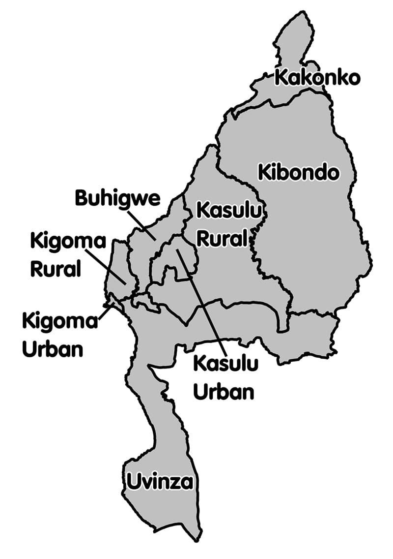
Kigoma Districts
Administratively, Kigoma region has eight districts.
| Map
|
District |
Population (as of 2012) |
| Kasulu Kigoma Tanzania Rural Area | 425,794 | |
| Uvinza District | 383,640 | |
| Kibondo Kigoma Tanzania District | 261,331 | |
| Buhigwe District | 254,342 | |
| Kigoma City Urban | 215,458 | |
| Kigoma District Council Rural | 211,566 | |
| Kigoma Kasulu Urban | 208,244 | |
| Kakonko District | 167,555 | |
| Total | 2,127,930 |

Kigoma Africa Demographics
The total population of Kigoma region stands at 2,127,930.
The biggest ethnic nationality living in Kigoma is the Ha people. Other significant populations are Watongwe, Wamanyema, Haya, Sukuma and Wavinza. Eighty thousand refugees from DR Congo and nearly 150,000 refugees from Burundi live in three refugee encampments in the region – Mtendeli, Nduta and Nyarugusu.
The main Kigoma language is known as Ha, which has some resemblance with Rwandese and Kirundi.
Frequently Asked Questions and Popular Things From and Found In Kigoma Region
- Kigoma Cichlid Species – The following list contains some of the popular Kigoma Fish found from Lake Tanganyika Kigoma:
- Frontosa Kigoma 7 stripe / 7 bar Kigoma Frontosa / 7 stripe Kigoma Frontosa (also known as just Kigoma Frontosa)
- Callochromis Pleurospilus Kigoma
- Cyathopharynx Furcifer Kigoma
- Cyphotilapia Frontosa Kigoma
- Cyprichromis Kigoma
- Cyprichromis Leptosoma Kigoma
- Cyprichromis Microlepidotus Kigoma
- Pterinochilus Murinus Dcf Kigoma
- Altolamprologus Compressiceps Kigoma Red
- Eretmodus Cyanostictus Kigoma (also familiarly known as Eretmodus Kigoma)
- Eretmodus Marksmithi Kigoma
- Lepidiolamprologus Boulengeri Kigoma
- Tropheus Duboisi Kigoma or just Tropheus Kigoma
- Enantiopus Melanogenys Kigoma
- Furcifer Kigoma
- Leptosoma Kigoma
- Spathodus Erythrodon Kigoma
- Xenotilapia Ochrogenys Kigoma
- Lamprologus Ornatipinnis Kigoma
- Tanganicodus Irsacae Kigoma
- Distances of Kigoma from major cities and destinations:
- Arusha to Kigoma – 15 hours and 47 minutes, 1,070.5 kilometers via B3
- Dodoma to Kigoma – 11 hours and 33 minutes, 799.0 kilometers driving through B129
- Bujumbura to Kigoma (Kigoma to Bujumbura) – 5 hr 18 min (281.8 km) via RN7
- Distance from Dar to Kigoma km wise (distance from Dar es salaam to Kigoma) – Approximately 1088 kms
- Distance from Kigoma to Mwanza – 11 hours and 6 minutes, 605.7 kilometers through B8 then B163
- Transportation Options:
- Train:
- Dar es salaam to Kigoma train – If you are planning to take a train from Dar es salaam to Kigoma (or Kigoma to Dar es salaam train), visit the TRC Booking timetable here https://booking.trc.co.tz/booking/timetable.
- Train:
- Kigoma Airport – Flights to Kigoma Tanzania
-
- Dar es salaam to Kigoma flight (Dar to Kigoma flight) – There are numerous airlines and flights operating Kigoma to Dar es salaam flight routes, explore your options here at Expedia.ca
- Dar es salaam to Kigoma google flights – https://www.google.com/flights/flights-to-kigoma.html
- Dar to Kigoma flights Air Tanzania – https://www.airtanzania.co.tz/index.php
-
-
- Air tanzania Dar to Kigoma price (air Tanzania Kigoma route) – https://www.airtanzania.co.tz/index.php
- Precision air Dar to Kigoma – https://www.precisionairtz.com/en/destinations
-
- Kigoma port – The Kigoma Bay’s Kigoma Port includes a 660-foot (200-meter) dock, numerous cranes, and is outfitted to accommodate shipping containers. The water depths at the wharfside, however, have decreased from 6 metres (20 feet) to 1.8 metres as a result of silting up in the bay caused by soil erosion from the hills nearby (5 ft 11 in). The port’s economic expansion may be at risk as a result of this. A plan to establish an economic zone at the port to promote trade and guarantee steady economic growth for the administration in power in 2015 and 2020 was unveiled by the Tanzanian government in May 2007.
-
- Arusha to Kigoma bus – See prices and schedules at Latra.go.tz
- Saratoga bus Kigoma – https://www.safaribay.net/saratoga-bus-line-dar-es-salaam/
- Adventure bus Kigoma contact – https://www.safaribay.net/adventure-connection-bus-kigoma-dar-es/
- Road:
-
- TANROADS Kigoma – https://www.tanroads.go.tz/regional-offices/office?slug=kigoma
- Hotels in Kigoma Tanzania
If you are thinking of available Kigoma hotels to stay at, here are some of the recommended hotels in Kigoma town to consider:
-
- Kigoma Hilltop Hotel Kigoma Tanzania – https://www.kigomahilltop.com/
- Lake Tanganyika hotel Kigoma Tanzania (Lake Tanganyika beach hotel Kigoma) – https://www.laketanganyikahotel.com/
- Mwitongo hotel Kigoma – By Booking.com
- Sunset vista hotel Kigoma – https://sunsetvistahotel.business.site
- Aqua lodge Kigoma – https://aqua-lodge-hostel.business.site/
- Coast view hotel Kigoma (Coast view resort Kigoma) – On Tripadvisor
- Green view hotel Kigoma – https://greenviewhotel.co.tz/
- Tanesco Kigoma – https://www.tanesco.co.tz/index.php/contacts/branch-offices/4:kigoma-regional-office
- House for sale in Kigoma Tanzania – If you are looking to buy houses in Kigoma, this classified will be a good starting point https://jiji.co.tz/kigoma/real-estate
- Kigoma Baptist Hospital – Get to know the details and work of this hospital at Baptistpress.com
- Kigoma Tanzania refugee camp
Kigoma refugee camp Tanzania specifically known as the Nyarugusu refugee camp Kigoma has almost 150,000 people, making it among the biggest and most well recognized camps hosting refugees of the twenty-first century. The camp location is situated around 150 kilometres on Lake Tanganyika eastern side in Tanzania’s western Kigoma province.The UNHCR established the camp with the government of Tanzania in year 1996 following the entrance of approximately 150,000 refugees from Congo eastern Sud-Kivu area that occured on the Tanzanian border, this was triggered by this mass of people who were fleeing civil strife in Congo. Despite the camp’s population declining before 2015, most of these refugees from Congo continued to stay there for decades. To flee violence and upheaval in Burundi, more than 110,000 refugees of Burundian descent entered Tanzania in 2015. Before the government of Tanzania permitted refugees from Burundi to relocate to different camping areas, these refugees lived in Nyarugusu.
- IOM Kigoma Tanzania – https://tanzania.iom.int/iom-tanzania
- Music and Media
- Kigoma song by Kigoma all stars Leka Dutigite / Alikiba Kigoma – https://www.youtube.com/watch?v=SmxmqPwysqE
- Kigoma all stars lyrics / Kigoma lyrics / Kigoma song lyrics – https://genius.com/Kigoma-all-stars-leka-dutigite-lyrics
- Download Kigoma mp3 – https://www.citimuzik.com/2020/12/kigoma-all-stars-leka-dutigite-mp3-download.html
- Radio Kwizera Kigoma – https://www.radiokwizera.com/
- Gombe Kigoma Tanzania – Jane Goodall Institute Kigoma Tanzania: https://janegoodall.org/
- Education and Career
-
- VETA:
-
-
- VETA Kigoma courses – https://veta.go.tz/vetcat/course/listCourse/13
- VETA Kigoma RVTSC – PDF
-
-
- Private schools in Kigoma – https://www.school.co.tz/schools-in-Kigoma
- Jobs in Kigoma – Google Jobs
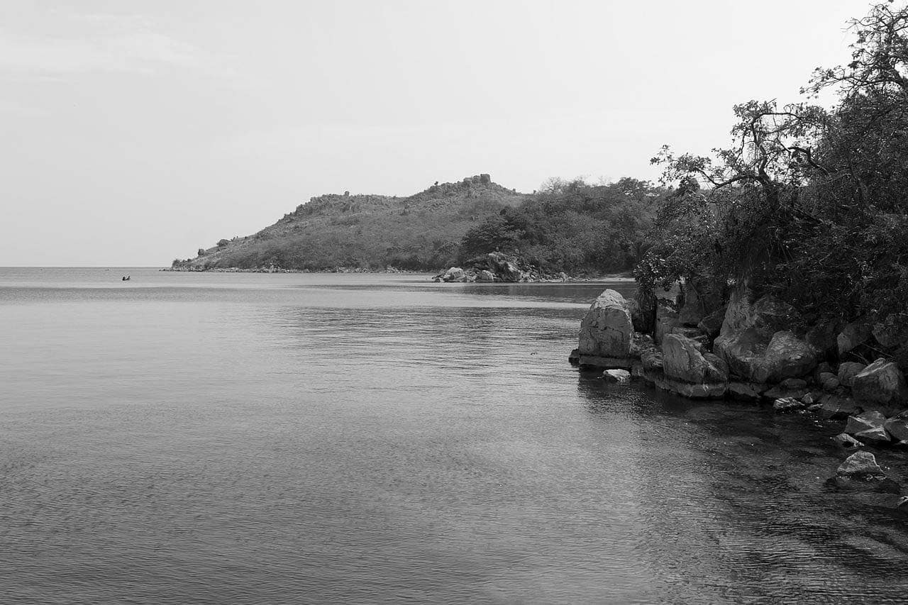
- Beaches in Kigoma:
-
- Bangwe beach Kigoma – Explore everything about the beach on Tripadvisor
- Jakobsen beach Kigoma – http://newsite.kigomabeach.com/
Kigoma Tanzania Map
For more articles related to regions of Tanzania click here!


