


")


Quick Overview of the Malagarasi River in Tanzania
The Malagarasi River is situated in the west of Tanzania. While one of its branches flows from Burundi in the southeast, the Malagarasi River flows through Kigoma. It has the biggest watershed of all the rivers running into Lake Tanganyika and is the second-longest river in the country (next to the Rufiji – Great Ruaha). The Malagarasi-Muyovozi Wetlands was named a Ramsar Site, and local tribes refer to as a river with bad spirits.
Geography
The Malagarasi River is 475 km long. Its source is close to the Tanzania-Burundi border, and its first 80 km make up the boundary between these two countries. Many branches from the Burundi upland flow into the Malagarasi River’s right bank.
Before emptying into Lake Tanganyika‘s eastern side, approximately 40 km south of Kigoma, near Ilagala, the Malagarasi River enters Tanzania after a confluence with the Lumpungu River and makes a circle. This inflow is one of Lake Tangayika’s primary inflows. Alongside the Nikongo River, the Moyowosi River is the main branch. Other branches include the Gombe River, the Lumpungu River, the Nguya River, the Ruchugi River, and the Ugalla River.
The Malagarasi River is classified as a low stream waterway and has four drainage biotopes. These biotopes are a running river with moderate rapids, a sizeable double-branched delta, swampy areas, and river channels.
Local agriculture, deforestation, which causes increased sediment levels, and the yearly wet and dry seasons influence the flow of the Malagarasi River. While being suspectable to flooding at times, the river can also reduce to a small stream.
The Malagarasi River flows through Precambrian crystalline rocks from the Archaean and Proterozoic ages, called the Dodoma Belt. Approximately 80 km from its mouth, the Malagarasi River runs through the Moyowosi swamplands, an area with a marshy labyrinth and extensive floodplains and swamps. At Mberagule, the river has been estimated to have a flow of 6.9 cubic km per year.
Watershed
The Malagarasi River’s watershed has a catchment area of 130,000 sq km. It accounts for 30% of Lake Tanganyika’s watershed area, making it the river with the greatest watershed to flow into this lake.
Most of the Malagarasi River’s basin is miombo woodland. Its two ruling tree species are the Brachystegia Spiciformis and the Julbernardia Globiflora. The Ugalla River’s middle and the Malagarasi-Moyowosi’s central basin are extensive flooded grassland areas along the southwest.
The northern Lake Victoria watershed binds the Malagarasi River watershed, and on the east, the Southern Eastern Rift binds it by a closed basin. The closed Lake Rukwa basin also binds it to the south and Lake Tanganyika to the east.
History
Rosemary Lowe-McConnel, an ecologist, stated that the Malagarasi River is presumed to be a relict headwater of the broadened pre-rift Zaire system, alongside the Rungwa River.
The Malagarasi River was a branch to the west of the Congo River during pre-rift times. It pre-dates Lake Tanganyika, which has undergone transgression and regression through deposits of new sediments and the altering of the delta. Over time, the path of Lake Tanganyika was changed as well, and its levels dramatically fluctuated between a hundred and two-hundred meters. Historical data captured in the late 1900s indicate that the Lake was approximately 10 m higher than today.
Culture
The Malagarasi River has been nicknamed “the river of bad spirits” by local tribes. The Wavinza tribe ran the ferry on the river in the late 1900s. The ferry service ran from the bank on the left side to avoid contact with the Wanyamwezi tribe. Avoiding assimilation was possible due to a natural barricade formed by the river. The Wangoni tribe (Watutu Zulus) was also on the other side.
Henry Morton Stanley believed that missionaries played an essential role in civilizing Africa. He stated they could follow the Malagarasi river route and partake in transformation tours to Ugala, Uha, and Uvinza.
Fauna and Flora
The Malagarasi river and basin is home to many fish and plant species. Several fish species in the Malagarasi river are also found in the Congo River Basin but not Lake Tanganyika. The Mbu Pufferfish, a large freshwater species, is found in the Malagarasi River and the Central and Upper Zaire Basin.
Plant species in the Malgarasi area include grass species such as Echinochloa, Hyparrhenia, and Themeda in the valley grasslands. The basin has trees like the Syzygium Owariense and Cordatum, the Phoenix Reclinate, the Parkia Filicoidea, the Khaya Senegalensis, the Isoberlinia spp., the Ficus Sycomorus and Verruculosa, the Diospyros Mespiliformis, the Cyperus Papyrus, the Bridelia Micrantha, and the Albizia Gummifera.
The Malagarasi-Muyovozi Wetlands
The Malagarasi-Muyovozi Wetlands is situated 1200 m highs in the basin’s middle at the joining point of the Malagarasi River and various other branch rivers, including the Ugalla, Gombe, and Muyovozi. Two Hundred and Fifty Thousand hectares of dry-season and unbarred water lakes such as the Nyamagoma and Sagara, as well as 200,000 hectares of perpetual papyrus swamp, are included in the wetland. On the bordering floodplain, varying seasonally-flooded grasslands with yearly rainfall make up approximately 1.5 million hectares.
The grass Oryza Barthii and the sedge Cyperus papyrus rule the papyrus swamps. The Echinochloa Pyramidalis, Hyparrhenia, and the Hyparrhenia Rufa are included in the seasonally-flooded grassland. The Enchinochloa rules the frequently flooded areas, the Vossia the perpetual wetlands, and the Hyparrhenia the least-flooded ones.
In the middle and upper Ugalla River reaches, seasonally-inundated floodplains of 120 km long and about 50 km wide are situated. The floodplain is ruled by the Andropogon spp., Digitaria spp., Enchinochloa Haploclada, Eragrostis spp., Setaria spp., Sporobolus pp., and Themeda Triandra grasses. Closed-canopy forests, in small patches on enormous termite mounds, Borassus Aethiopum palm groves, C. Obovatum, Combretum Fragrans, and C. Purpureiflorum trees are scattered on the floodplains.
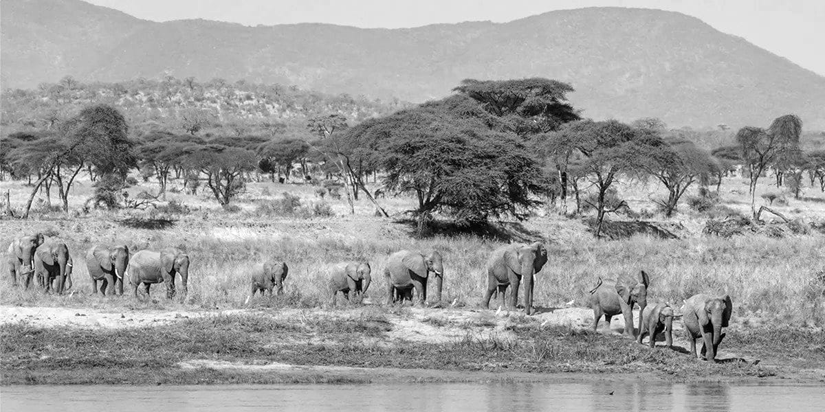
The wetland is home to many endangered and vulnerable animals. Included are the Bugeranus Carunculatus (Wattled Crane), Balaeniceps Rex (Shoebill), Loxodonta Africana (African Bush Elephant), Mecistops Leptorhynchus (Central African Slender-Snouted Crocodile), and the Tragalephus Spekii (Sitatunga). The Pollimyrus Nigricans (Dark Stonebashed) and many other endemic, endangered, and food species make up the 50 fish species of the wetlands. Also familiar in the wetlands are the Hippopotamus Amphibius (Hippopotamus) and the Kobus Ellipsiprymnus (Waterbuck).
The Wanvahosa tribe prefers to eat meat instead of fish, and possible poaching of the river basin’s hippo has raised concerns.
Protected Areas Surrounding the Malagarasi River
After the Malagarasi-Muyovozi Wetlands was named a Ramsar Site on the 13th of April 2000, it became a protected area. It is Tanzania’s first Ramsar Site and also the third-largest in the world at 35,000 sq km.
For more articles related to Rivers of Tanzania, click here!


