


")


Climate Change – Rain Season in Tanzania and Weather in General
Tanzania is a large African country that overlooks the Indian Ocean and is located south of the equator. Much of the country is covered by steep plateaus (English plateau), where a large number of the world’s most popular tourist attractions are found, in particular, the savannah landscapes with flowers and animals of all kinds, preserved in parks and nature reserves. The valley has a warm or tropical climate, not too hot because of the elevation. On the contrary, the narrow coastline is warm and humid year-round, especially from November to April.
The June-August (winter) period is the coldest in the year, and is dry almost everywhere.
What is the Raining Season in Tanzania?
In terms of rain season in Tanzania, the country can be divided into four areas. In the north and east, except in the area around Lake Victoria, there are two rainy seasons: one is heavy, known as the autumn (autumn) rainy season, between October and December, and the other more severe, known as the longest rainy season (spring), from March to May, and the peaks is in April. In the months of January and February, in the period between the two rainy seasons (summer), the weather is warm and steam, at least less than a thousand meters (3,300 feet). In the far northwest, two rainy seasons coincide, raining until January and February, with rainfall reaching up to 100/150 millimeters (4/6 inches) per month depending on the area; therefore, in this area, there is generally only one rainy season from October to May. A similar situation exists in a few northeastern areas, in particular, along the southern slopes of Mount Kilimanjaro.
There is only one rain season in Tanzania’s middle and south side, from December to April in the south and south-east, and from November to western west.
Tropical rains fall mainly in the form of heavy rain accompanied by thunder during the day, so in the morning the sky is often white even during the raining season in Tanzania.
The Coast
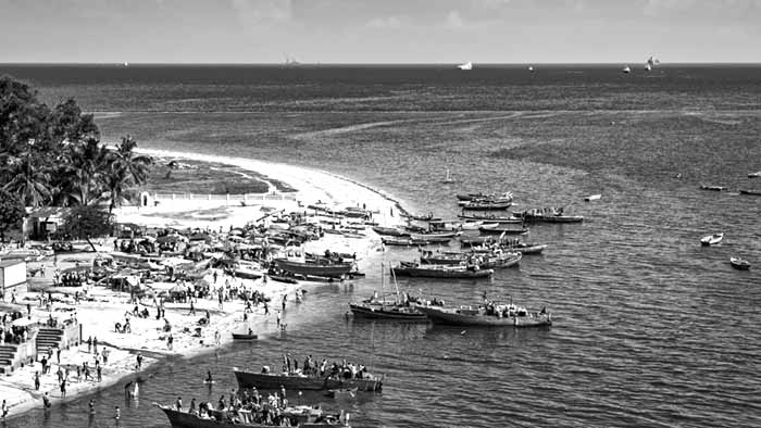
On the coast, the climate is warm all year round, with two rainy seasons in the northern part, and only one in the southern part.
Dar Es Salaam
Dar es salaam, the largest city and former capital of Tanzania, is located on the coast, in the area with two rainy seasons, and is warm all year round, with the hottest and rainy period from November to April, where the daytime heat is around 31/32 ° C (88/90 ° F), rising at a maximum of 35/36 ° C (95/97 ° F). The average humidity is high, especially in March and April, the wettest months of all. The following is the average temperature:
Dar Es Salaam – Average temperatures
| Month | Jan | Feb | Mar | Apr | May | Jun | Jul | Aug | Sep | Oct | Nov | Dec |
|---|---|---|---|---|---|---|---|---|---|---|---|---|
| Low Level (°C) | 24 | 23 | 23 | 22 | 21 | 19 | 18 | 18 | 18 | 20 | 21 | 23 |
| High Level (°C) | 32 | 32 | 32 | 31 | 30 | 29 | 29 | 29 | 30 | 31 | 31 | 32 |
| Low Level (°F) | 75 | 73 | 73 | 72 | 70 | 66 | 64 | 64 | 64 | 68 | 70 | 73 |
| High Level (°F) | 90 | 90 | 90 | 88 | 86 | 84 | 84 | 84 | 86 | 88 | 88 | 90 |
In Dar Es Salaam, the annual rainfall is 1,150 mm (45 in), with the highest level from March to May; April is the month of heavy rainfall of 255 mm (10 inches). There is a second highest level, of short rainfall, from October to December. However, overall rainfall is not uncommon, because, in some years, a short rainy season can be a long haul. From June to September, there is a very short rain season in Tanzania’s big city of Dar es salaam; this period, in addition to being the driest, is also cooler, with temperatures around 29/30 ° C (84/86 ° F) and low at around 18 ° C (64 ° F), although sometimes the temperature at night it can drop to around 15 ° C (59 ° F).
The following are the average rainfall:
Dar Es Salaam – Average rainfall
| Month | Jan | Feb | Mar | Apr | May | Jun | Jul | Aug | Sep | Oct | Nov | Dec | Year |
|---|---|---|---|---|---|---|---|---|---|---|---|---|---|
| Rain (mm) | 75 | 55 | 140 | 255 | 200 | 45 | 25 | 25 | 25 | 70 | 125 | 120 | 1150 |
| Rain (in) | 3 | 2.2 | 5.5 | 10 | 7.9 | 1.8 | 1 | 1 | 1 | 2.8 | 4.9 | 4.7 | 45.3 |
| Days | 7 | 4 | 11 | 18 | 13 | 5 | 4 | 4 | 3 | 5 | 8 | 9 | 91 |
The amount of sunlight in Dar Es Salaam is good for the whole year, except in April, the wettest month of all.
Dar Es Salaam – Sun
| Month | Jan | Feb | Mar | Apr | May | Jun | Jul | Aug | Sep | Oct | Nov | Dec |
|---|---|---|---|---|---|---|---|---|---|---|---|---|
| Hours | 8 | 8 | 7 | 5 | 7 | 7 | 7 | 9 | 8 | 9 | 8 | 8 |
The sea in Dar es Salaam (as in all of Tanzania) has a temperature that is comfortable for swimming at any time: the water temperature ranges from 25 ° C (77 ° F) in August to 29 ° C (84 ° F) in the summer months.
Dar Es Salaam – Sea Temperature
| Month | Jan | Feb | Mar | Apr | May | Jun | Jul | Aug | Sep | Oct | Nov | Dec |
|---|---|---|---|---|---|---|---|---|---|---|---|---|
| Temperature (°C) | 29 | 29 | 29 | 29 | 28 | 27 | 26 | 25 | 26 | 26 | 28 | 29 |
| Temperature (°F) | 84 | 84 | 84 | 84 | 82 | 81 | 79 | 77 | 79 | 79 | 82 | 84 |
Together, the climate and rainfall are similar on Zanzibar Island, however, it rains heavily there: about 1,600 mm (63 in) per year in Zanzibar, and up to 1,900 mm (75 in) north of Pemba Island .
Plateau
On a country’s plateau, temperatures vary in elevation, although it is usually relatively warm or unbearable for over a year. The amount of rainfall tends to increase due to the elevation, but it also depends on the severity of the slope and the proximity of the high mountains, so there is a combination of areas with more and less rainfall.
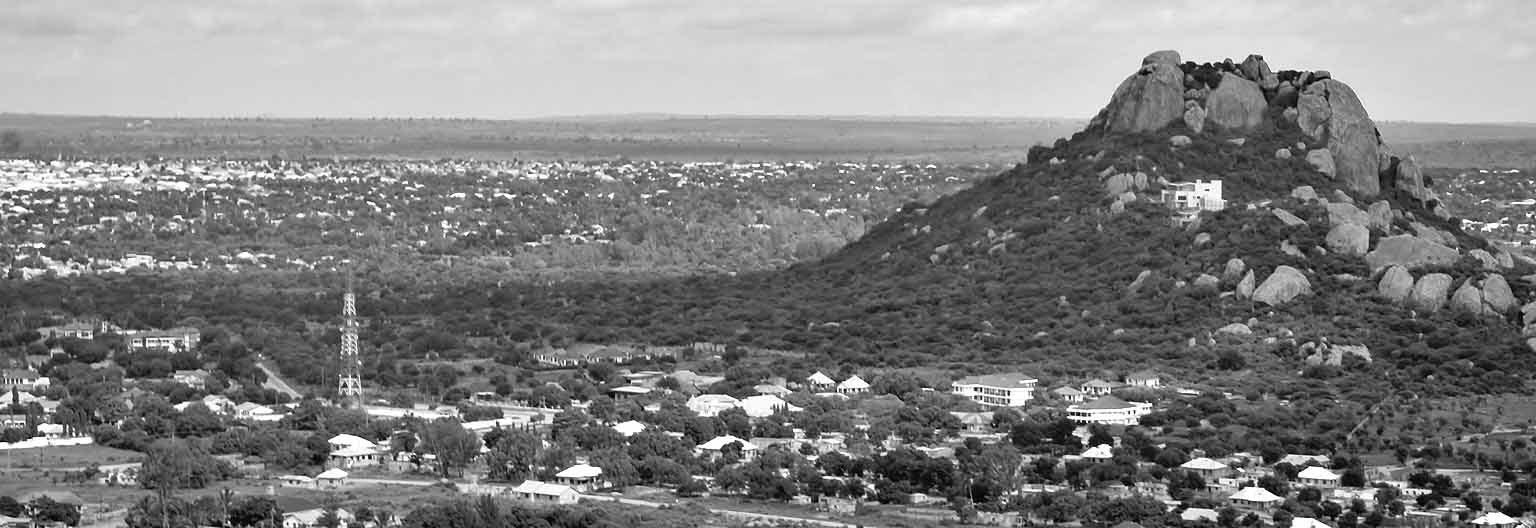
Dodoma
Dodoma, the capital of Tanzania, is at 1,100 meters (3,600 meters) above sea level, in the arid mainland, and has a single rainy season. In a typical year, only 600 millimeters (23.5 in) of rain showers, most occur in December to mid-April, while from May to October there is no rain at all.
The following is the average rainfall:
Dodoma – Average rainfall
| Month | Jan | Feb | Mar | Apr | May | Jun | Jul | Aug | Sep | Oct | Nov | Dec | Year |
|---|---|---|---|---|---|---|---|---|---|---|---|---|---|
| Rainfall (mm) | 135 | 145 | 115 | 60 | 5 | 0 | 0 | 0 | 0 | 2 | 25 | 125 | 605 |
| Rainfall (in) | 5.3 | 5.7 | 4.5 | 2.4 | 0.2 | 0 | 0 | 0 | 0 | 0.1 | 1 | 4.9 | 23.8 |
| Days | 10 | 9 | 7 | 5 | 1 | 0 | 0 | 0 | 0 | 0 | 2 | 7 | 41 |
In the months of October and November, before the rains, there may be temperatures, reaching a peak of about 35 ° C (95 ° F) until February. Therefore, the best time to visit Tanzania Dodoma region is from May to September, when the temperature is around 27/29 ° C (81/84 ° F) during the day and around 14/15 ° C (27/29 ° F) at night; sometimes, there may be extreme cold at night, around 8/10 ° C (46/50 ° F).
The following are the average temperatures:
Dodoma – Average temperatures
| Month | Jan | Feb | Mar | Apr | May | Jun | Jul | Aug | Sep | Oct | Nov | Dec |
|---|---|---|---|---|---|---|---|---|---|---|---|---|
| Low Level (°C) | 19 | 19 | 18 | 18 | 17 | 14 | 14 | 14 | 15 | 17 | 18 | 19 |
| High Level (°C) | 29 | 29 | 29 | 29 | 28 | 27 | 27 | 27 | 29 | 31 | 30 | 30 |
| Low Level (°F) | 66 | 66 | 64 | 64 | 63 | 57 | 57 | 57 | 59 | 63 | 64 | 66 |
| High Level (°F) | 84 | 84 | 84 | 84 | 82 | 81 | 81 | 81 | 84 | 88 | 86 | 86 |
In Iringa, the climate is similar, but slightly cooler, as the city is 1,400 meters (4,600 feet) above sea level, and therefore less temperate, and sometimes colder at night, especially from May until September.
Kilimanjaro
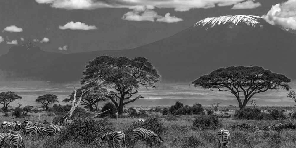
In the northeast, during rain season in Tanzania in this area, we find high mountains, including Mount Kilimanjaro, 5,895 meters (19,340 meters) high, which is also the tallest mountain in Africa, with lasting snow more than 5,000 meters ( 16,400 ft), unfortunately declining due to global warming. On the slopes, there are different climates, flowers and animals depending on the height: between 1,800 and 2,800 meters (5,900 and 9,200 ft), we find a rain forest; between 2,800 and 4,000 meters (9,200 and 13,100 ft), at night the temperature may drop below freezing (0 ° C or 32 ° F), dry mountain vegetation; between 4,000 and 5,000 meters (13,000 and 16,500 ft), the cold desert, when, during the day the equatorial sun is very hot, and can boil open rocks, while at night, it is very cold. At the top of the mountain, which is often above the cloud layer, temperatures can drop to -15 / -25 ° C (5 / -13 ° F) at night. Considering all the temperatures (which are highest in January and February, and low from June to August) and rainfall (which is highest from March to June, and low from August to October), it is generally best to climb the mountain in January February and September, and to avoid the worst months of April and May because of heavy rainfall (and even snowfall) and frequent cloud cover. Some visitors choose days when the moon is eclipsed, a phenomenon that occurs approximately once a month, during which the snow is illuminated by the moon and provides beautiful scenery at night.
West of Kilimanjaro, we find another mountain, Mount Meru, 4,565 meters (14,977 meters high).
Arusha
At the beginning of Mount Meru, 1,400 meters (4,600 feet), we find the city of Arusha. Here, the temperatures are pleasant throughout the year, with average daily temperatures ranging from 19 ° C (66 ° F) between January and April to 14.5 ° C (58 ° F) in June and July. Sometimes, however, between November and March, it can be warm during the day. The nights are cold all year round, especially from June to September, when low temperatures can drop below 10 ° C (50 ° F), during the day, temperatures fluctuate around 20-252 C (68/72 ° F) .
Arusha – Average temperatures
| Month | Jan | Feb | Mar | Apr | May | Jun | Jul | Aug | Sep | Oct | Nov | Dec |
|---|---|---|---|---|---|---|---|---|---|---|---|---|
| Low Level | 10 | 10 | 11 | 13 | 11 | 8 | 9 | 8 | 8 | 10 | 10 | 10 |
| High Level | 28 | 28 | 27 | 25 | 22 | 21 | 20 | 22 | 24 | 26 | 27 | 27 |
| Low Level (°F) | 50 | 50 | 52 | 55 | 52 | 46 | 48 | 46 | 46 | 50 | 50 | 50 |
| High Level (°F) | 82 | 82 | 81 | 77 | 72 | 70 | 68 | 72 | 75 | 79 | 81 | 81 |
Rainfall in the Arusha region reaches 1,100 mm (43 in) per year.
The following are the average rainfall:
Arusha – Average rainfall
| Month | Jan | Feb | Mar | Apr | May | Jun | Jul | Aug | Sep | Oct | Nov | Dec | Year |
|---|---|---|---|---|---|---|---|---|---|---|---|---|---|
| Rainfall (mm) | 65 | 65 | 145 | 340 | 170 | 40 | 20 | 15 | 15 | 40 | 125 | 90 | 1125 |
| Rainfall (in) | 2.6 | 2.6 | 5.7 | 13.4 | 6.7 | 1.6 | 0.8 | 0.6 | 0.6 | 1.6 | 4.9 | 3.5 | 44.3 |
| Days | 12 | 12 | 15 | 21 | 14 | 5 | 5 | 4 | 3 | 6 | 15 | 15 | 127 |
In Arusha, the amount of sunlight, which is good for the whole year as a whole, decreases slightly in the rainy months, but does not increase much in the colder and drier months, which are June and July.
Arusha – Sun
| Month | Jan | Feb | Mar | Apr | May | Jun | Jul | Aug | Sep | Oct | Nov | Dec |
|---|---|---|---|---|---|---|---|---|---|---|---|---|
| Hours | 9 | 9 | 8 | 6 | 6 | 6 | 7 | 7 | 8 | 9 | 8 | 8 |
Serengeti
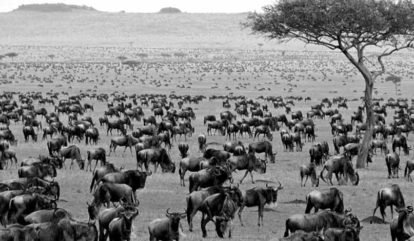
The Serengeti National Park is located in the northwest of Arusha, towards Lake Victoria and the border with Kenya; here, the height is between 1,100 and 2,000 meters (3,600 / 6,600 feet). This is the savanna area, a type of grassland that becomes greener and taller in as rain season in Tanzania progress in this area. Rare trees such as giant baobab trees, and animals such as rhinos, hippos, giraffes, elephants, lions, males, leopards are populous in this area. The arid part of the Serengeti, where trees are scarce, is southeast.
The following is an average temperature recorded at 1,400 meters (4,600 feet) above sea level.
Serengeti – Average Temperature
| Mwezi | Jan | Feb | Mar | Apr | May | Jun | Jul | Aug | Sep | Oct | Nov | Dec |
|---|---|---|---|---|---|---|---|---|---|---|---|---|
| Low Level (°C) | 16 | 16 | 16 | 16 | 16 | 15 | 14 | 15 | 15 | 16 | 16 | 16 |
| High Level (°C) | 29 | 29 | 29 | 28 | 27 | 27 | 26 | 27 | 28 | 29 | 28 | 28 |
| Low Level (°F) | 61 | 61 | 61 | 61 | 61 | 59 | 57 | 59 | 59 | 61 | 61 | 61 |
| High Level (°F) | 84 | 84 | 84 | 82 | 81 | 81 | 79 | 81 | 82 | 84 | 82 | 82 |
Olduvai Gorge, the first human settlement, where fossils were found, is located between the Serengeti and the Ngorongoro Conservation Area, at 1,400 meters (4,600 meters) above sea level. This area has the driest climate.
Ngorongoro
Unlike the Serengeti, the Ngorongoro Conservation Area is the wettest, at least in the highlands, which exceeds 2000 meters (6,500 feet). In the city of the same name, which is at 2,400 meters (7,900 ft), the weather is like spring all year round, and on cold nights, sometimes very cold, during the day it is warm from October to March. , and cool from May to September. Here, as in the far northwest, thunderstorms can sometimes occur even during the dry season, between January and February.
Ngorongoro – Average temperature
| Month | Jan | Feb | Mar | Apr | May | Jun | Jul | Aug | Sep | Oct | Nov | Dec |
|---|---|---|---|---|---|---|---|---|---|---|---|---|
| Low Level (°C) | 10 | 10 | 10 | 11 | 10 | 8 | 8 | 8 | 8 | 9 | 10 | 10 |
| High Level (°C) | 23 | 23 | 22 | 21 | 20 | 19 | 19 | 20 | 21 | 22 | 22 | 22 |
| Low Level (°F) | 50 | 50 | 50 | 52 | 50 | 46 | 46 | 46 | 46 | 48 | 50 | 50 |
| High Level (°F) | 73 | 73 | 72 | 70 | 68 | 66 | 66 | 68 | 70 | 72 | 72 | 72 |
In Tanzania, there are several large lakes.
Mwanza
Lake Victoria is located in the northwest, at 1,100 meters (3,600 meters) above sea level; here, the weather is warm all year round, as we see the heat of Mwanza city.
Mwanza – Average Temperature
| Month | Jan | Feb | Mar | Apr | May | Jun | Jul | Aug | Sep | Oct | Nov | Dec |
|---|---|---|---|---|---|---|---|---|---|---|---|---|
| Low Level (°C) | 18 | 18 | 18 | 18 | 18 | 16 | 15 | 16 | 17 | 18 | 18 | 18 |
| High Level (°C) | 28 | 28 | 29 | 28 | 28 | 28 | 28 | 29 | 29 | 29 | 28 | 27 |
| Low Level (°F) | 64 | 64 | 64 | 64 | 64 | 61 | 59 | 61 | 63 | 64 | 64 | 64 |
| High Level (°F) | 82 | 82 | 84 | 82 | 82 | 82 | 82 | 84 | 84 | 84 | 82 | 81 |
Mwanza rainfall reaches 1,050 mm (41 in) per year; the city is located in the area of one rainy season, from October to May. The following is the average rainfall:
Mwanza – Average rainfall
| Month | Jan | Feb | Mar | Apr | May | Jun | Jul | Aug | Sep | Oct | Nov | Dec | Year |
|---|---|---|---|---|---|---|---|---|---|---|---|---|---|
| Rainfall (mm) | 105 | 110 | 140 | 170 | 75 | 20 | 10 | 20 | 25 | 85 | 155 | 140 | 1050 |
| Rainfall (in) | 4.1 | 4.3 | 5.5 | 6.7 | 3 | 0.8 | 0.4 | 0.8 | 1 | 3.3 | 6.1 | 5.5 | 41.3 |
| Days | 10 | 8 | 11 | 14 | 8 | 2 | 1 | 2 | 3 | 8 | 13 | 12 | 92 |
In Mwanza, the sun shines all year round, becoming more intense during the dry season.
Mwanza – Sun
| Month | Jan | Feb | Mar | Apr | May | Jun | Jul | Aug | Sep | Oct | Nov | Dec |
|---|---|---|---|---|---|---|---|---|---|---|---|---|
| Hours | 7 | 7 | 7 | 7 | 8 | 9 | 9 | 9 | 8 | 8 | 7 | 7 |
Going further south, Lake Tanganyika, along the East African Rift Valley, is 770 meters (2,500 meters) above sea level, and further south, you find Lake Malawi which is 480 meters (1,570 feet), along its state beaches. the air is warm. because of the low height. There are several national parks and nature reserves in the middle-south as well.
Tropical Hurricanes
The central and southern part of Tanzania is located just south of the equator, at the edge of the area where tropical cyclones occur; while the northern part of the coast (Dar Es Salaam, Zanzibar) is not affected at all, the south-eastern states (Lindi, Mtwara) are more likely to be affected, to some extent, by hurricanes passing over the Comoros and Mayotte area. South West Indian Ocean hurricanes occur from November to mid-May, but most often from late December to mid-April.
For the overall climate insight, factors that impact and the different sectors involved, visit our other article “Tanzania Climate Conditions Profile“.
Last but not the least, if interested to explore more articles related to weather click here!


